
Kudat District
Kudat District
Daerah Kudat | ||
|---|---|---|
District | ||
 Kudat District Council office. | ||
|
Country | ||
| State | ||
| Division | Kudat | |
| Capital | Kudat | |
| Government | ||
| • District Officer | Sebastian Lim | |
| Area | ||
| • Total | 1,287 km2 (497 sq mi) | |
| Population (2010) | ||
| • Total | 83,140 | |
| Website | www | |

The Kudat District (
Etymology
In the past, Kudat was known locally as "Tanjong Berungus" and sometimes also called "Tambarungan". During the early arrival of Chinese traders at Tanjung Berungus, they were surprised to see a kind of grass growing everywhere. The desperation forced them to ask the locals comprising the Rungus tribes who are the native inhabitants of the place who later explained to them that the grass are called "Kutad" in their language. The place then became the centre of meeting between the local and Chinese traders to carry out trading activities.[1] However, since the Chinese pronunciation was inaccurate, the term "Kudat" eventually emerging and became synonymously used among the people. While another story from the Binadan people explained the word Kudat comes from a reaction “takkudad aku” in their language which mean "I am shocked" after a people from their tribes shocking when hearing a ship named Santi while they sailing from Limau-Limauan to Tanjung Berungus. The event subsequently gave them an idea among their community who also agreed to name Tanjung Berungus as Kudat.[1]
History
The area around Kudat was once under the
Demographics
According to the last census in 2010, the population of Kudat district is estimated to be around 83,140.
Gallery
-
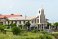
 Asy-Syakirin Mosque.
 -
 Sin San Anglican Church.
 -
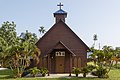
 Kudat Basel Church.
 -
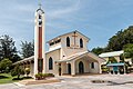 St. Peter Catholic Church.
 -
 Fuk Tek Kung Temple.
 -
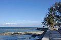 Bak Bak beach.


See also
- Districts of Malaysia
References
- ^ a b c "Asal-Usul Kudat dari Perspektif Lagenda Tempatan dan Kronologi Sejarah Pentadbiran Awal Daerah Kudat" (in Malay). Kudat District Office. Archived from the original on 7 November 2017. Retrieved 8 November 2017.
- ^ "Population by ethnic group, Local Authority area and state, Malaysia" (PDF). Department of Statistics, Malaysia. 2010. Archived from the original (PDF) on 27 February 2012. Retrieved 5 November 2017.
Further reading
- Treacher, W. H (1891). "British Borneo: sketches of Brunai, Sarawak, Labuan, and North Borneo". University of California Libraries. Singapore, Govt. print. dept. p. 190.
- Rutter, Owen (1922). "British North Borneo - An Account of its History, Resources and Native Tribes". Cornell University Libraries. Constable & Company Ltd, London. p. 157.
- Tregonning, K. G. (1965). A History Of Modern Sabah (North Borneo 1881–1963). University of Malaya Press.
External links
![]() Media related to Kudat District at Wikimedia Commons
Media related to Kudat District at Wikimedia Commons
- (in Malay) Kudat District Office
Capital: Kota Kinabalu | |||||||||||
| Topics |
| ||||||||||
| Society |
| ||||||||||
| Administrative divisions |
| ||||||||||