
Kota Marudu District
Kota Marudu District
Daerah Kota Marudu | ||
|---|---|---|
District | ||
|
Country | ||
| State | ||
| Division | Kudat | |
| Capital | Kota Marudu | |
| Government | ||
| • District Officer | Alexander Yong | |
| Area | ||
| • Total | 1,917 km2 (740 sq mi) | |
| Population (2010) | ||
| • Total | 66,374 | |
| Website | www www | |

The Kota Marudu District (
Etymology
Kota means Fort. The name Marudu originated from the language of Balangigi people from the words of "Mairudu" or "Maiuludu" which means "a position located in the same place", referring to the geographical position of
History
The district is once known as the stronghold of a local leader named Sharif Usman. The Sharif administer the area under the consent of the
Demographics
The population of Kota Marudu district according to the last census in 2010 is 66,374.
Gallery
-
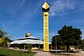 Tandek Mosque.
 -
 Kota Marudu Basel Church.
 -
 St. Theresa Catholic Church.
 -
 Goshen Seventh Day Adventist Church.
 -
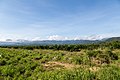 Crocker Range.


See also
- Districts of Malaysia
Notes
References
- ISBN 978-88-7652-879-8.
- ^ a b "Latar Belakang Daerah" (in Malay). Kota Marudu District Office. Archived from the original on 7 November 2017. Retrieved 7 November 2017.
- ISBN 978-1-136-87394-2.
- ^ "Population by ethnic group, Local Authority area and state, Malaysia" (PDF). Department of Statistics, Malaysia. 2010. Archived from the original (PDF) on 27 February 2012. Retrieved 5 November 2017.
Further reading
- Treacher, W. H (1891). "British Borneo: sketches of Brunai, Sarawak, Labuan, and North Borneo". University of California Libraries. Singapore, Govt. print. dept. p. 190.
- Rutter, Owen (1922). "British North Borneo - An Account of its History, Resources and Native Tribes". Cornell University Libraries. Constable & Company Ltd, London. p. 157.
- Tregonning, K. G. (1965). A History Of Modern Sabah (North Borneo 1881–1963). University of Malaya Press.
External links
![]() Media related to Kota Marudu District at Wikimedia Commons
Media related to Kota Marudu District at Wikimedia Commons
- (in Malay) Kota Marudu District Council
- (in Malay) Kota Marudu District Office
Capital: Kota Kinabalu | |||||||||||
| Topics |
| ||||||||||
| Society |
| ||||||||||
| Administrative divisions |
| ||||||||||