
Lindenhof (Rapperswil)
Lindenhof in Rapperswil is a


Geography
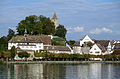
Lindenhof hill (its eastern part is called Herrenberg) dominates the old city of
In the south, just a few dozens meters away, at the landing gate of the
Points of interest
Lindenhof (literally: Tilia court) is named after the
At Schlosshügel the
The Rapperswil Castle, built in the early 13th century by Rudolf II and Rudolf II von Rapperswil, houses the Polenmuseum and the Poland memorial column. Inside the castle's palais, there is located the Schloss Restaurant having a rather expensive cuisine,[1] but there's yet no tourist shop, kiosk or snack bar. Just a few meters easterly of the three-cornered castle, the about 800 years old Stadtpfarrkirche (parish church) and its cemetery chapel named Liebfrauenkapelle (built in 1489) are situated at the Herrenberg street, as well as the Stadtmuseum Rapperswil-Jona, a former small castle, and later part of the 15th-century northeasterly town wall towards Engelplatz. The latter is the former late medieval bastion and the eastern end of the Lindenhof hill and Rapperswil's historical core.
-
 Endingerhorn fortification and medieval town hall at thepaddle steamer Stadt Rapperswil
 -

-
 Schlosshalde around 1825 AD,aquatintaby Meinrad Kälin
 -
 Aquatinta around 1840
 -
 Rapperswil und Umgebung around 1835
 -
 Scale model at theStadtmuseum Rapperswil
 -
 Lindenhof and Herrenberg area in 1919, aerial photograph by Walter Mittelholzer


.JPG)


.JPG)
.JPG)
Protection
The hillside area is as part of the castle and the museum listed in the
Renewal
In June 2012 the citizens of Rapperswil (Bürgerversammlung) voted to re-design the tophill Lindenhof area, but the proposal was too extensive, so a stripped-down variant was accepted in December, reducing the costs down from 1 million to 380,000 Swiss Francs. Some of the old trees had been cut down in winter 2010/2011 as they were fungal infestated; instead of two rows of trees there was one realized, and in addition, the rose bushes at the castle were preserved. Lindenhof remained an open area, and the slopes got shady promenades thanks to new plantings. The historic metal railing at the viewing platforms were retained and supplemented with fall protection as they no longer met the safety requirements; the project was managed by Hager & Partner. The Deer park also was remodeled, and the mammals got a rebuilt stable and more space for retreats.[3]
Literature
- Peter Röllin: Kulturbaukasten Rapperswil-Jona: 36 Museen ohne Dach. Rapperswil-Jona 2005, ISBN 3-033-00478-4.
- Gerold Späth: Stilles Gelände am See. Suhrkamp, Berlin 1991.[4]
References
- ^ "Schloss Restaurant Rapperswil" (in German). Schloss Restaurant Rapperswil. Archived from the original on 2016-09-21. Retrieved 2014-11-27.
- ^ "Schweizerisches Inventar der Kulturgüter von nationaler Bedeutung: Kanton St. Gallen, A-Objekte" (PDF) (in German). bevoelkerungsschutz.admin.ch. 2015-01-01. Archived from the original (PDF) on 2015-12-19. Retrieved 2015-09-14.
- ^ Magnus Leibundgut (2013-10-01). "Schlosshalde und Lindenhof erhalten ein neues Gesicht" (in German). Zürichsee-Zeitung. Archived from the original on 2014-12-05. Retrieved 2014-11-27.
- ^ Martin Lüdke (2001-11-08). "Gerold Späths Romankonvolut "Stilles Gelände am See"" (in German). Die Zeit. Retrieved 2014-12-07.
External links
| Settlements |
|   | |||||||||
|---|---|---|---|---|---|---|---|---|---|---|---|
| Islands | |||||||||||
| Rivers | |||||||||||
| Valleys | |||||||||||
| Mountains | |||||||||||
| Landmarks | |||||||||||
| Transportation |
| ||||||||||
| People | |||||||||||