
Jona (river)
| Jona | |
|---|---|
MAMSL | |
The Jona is a river in the Swiss cantons of Zürich and St. Gallen.
Geography

The Jona rises on the eastern slope of
Zürichsee
.
History and some facts
The river's name was first mentioned in 834 AD, the former municipality Jona was named much later. It is assumed that the name originates as either Celtic Jauna (the cold one) – the Jona is still largely determined by forest area – or, as Indo-European yamam, meaning stream. Latest interpretations say that the Indo-European word jeu roughly means to move, followed by the Old High German name Jouna .[2]
Its
industrialization
of the textile industry of the communities of Wald, Rüti, and Rapperswil-Jona.
The Jona measures 20 kilometres (12.4 mi) in all, rising at 950 metres (3,117 ft) (m.ü.M, i.e. above sea level) and flowing in Obersee at 406 metres (1,332 ft) asl. The river belongs to the
Aar→Rhine system. Its drainage basin
measures 65 square kilometres (25.1 sq mi)
Gallery
-
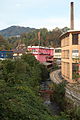
 Tannertobel between Tann and Rüti
 -
 Joweid (= Jona river meadow) inRüti (ZH), Bachtelmountain in the background
 -
 The Jona at Holzwies in Jona (SG)
 -
 The river within the village of Jona
 -
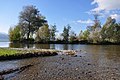 Oberseein the background


_-_Jona_IMG_1803.JPG)
_Stampf_IMG_1886.JPG)
References
External links
Wikimedia Commons has media related to Jona (Fluss).
- Dorfverein Wagen (in German)
| Settlements |
|   | |||||||||
|---|---|---|---|---|---|---|---|---|---|---|---|
| Islands | |||||||||||
| Rivers | |||||||||||
| Valleys | |||||||||||
| Mountains | |||||||||||
| Landmarks | |||||||||||
| Transportation |
| ||||||||||
| People | |||||||||||