
Littleton, New Hampshire
Littleton, New Hampshire | ||
|---|---|---|
Town | ||
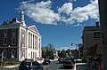
 Littleton Courthouse and Post Office | ||
|
FIPS code 33-42580 | | |
| GNIS feature ID | 0873649 | |
| Website | www | |
Littleton is a
The main village in town, where 4,467 people lived at the 2020 census, is defined as the Littleton census-designated place (CDP) and is centered on the intersection of U.S. Route 302 with New Hampshire Route 116, along the Ammonoosuc River.
History
Called "Chiswick" (
Located along the banks of the Ammonoosuc River is the Littleton Grist Mill. The historic mill first opened in 1798, and has been fully restored to its original appearance. Between 1867 and 1909, the local Kilburn Brothers factory published photographs and stereoviews, and sold
Geography
According to the United States Census Bureau, the town has a total area of 54.0 square miles (139.9 km2), of which 50.0 square miles (129.4 km2) are land and 4.1 square miles (10.5 km2) are water, comprising 7.48% of the town.[1] The main village of Littleton, a census-designated place, has a total area of 8.6 square miles (22 km2), of which 0.12% is water.
Littleton is drained by the Connecticut River and its tributary, the Ammonoosuc River. The Connecticut River serves as the state boundary with Vermont. The Moore Dam on the Connecticut forms Moore Reservoir in the north. The highest point in Littleton is the summit of Towns Mountain, at 2,203 feet (671 m) above sea level in the northeast part of town.
Demographics
| Census | Pop. | Note | %± |
|---|---|---|---|
| 1790 | 96 | — | |
| 1800 | 381 | 296.9% | |
| 1810 | 873 | 129.1% | |
| 1820 | 1,096 | 25.5% | |
| 1830 | 1,435 | 30.9% | |
| 1840 | 1,778 | 23.9% | |
| 1850 | 2,008 | 12.9% | |
| 1860 | 2,292 | 14.1% | |
| 1870 | 2,446 | 6.7% | |
| 1880 | 2,936 | 20.0% | |
| 1890 | 3,365 | 14.6% | |
| 1900 | 4,066 | 20.8% | |
| 1910 | 4,069 | 0.1% | |
| 1920 | 4,239 | 4.2% | |
| 1930 | 4,558 | 7.5% | |
| 1940 | 4,571 | 0.3% | |
| 1950 | 4,817 | 5.4% | |
| 1960 | 5,003 | 3.9% | |
| 1970 | 5,290 | 5.7% | |
| 1980 | 5,558 | 5.1% | |
| 1990 | 5,827 | 4.8% | |
| 2000 | 5,845 | 0.3% | |
| 2010 | 5,928 | 1.4% | |
| 2020 | 6,005 | 1.3% | |
| U.S. Decennial Census[1][4] | |||
As of the
There were 2,673 households, out of which 26.9% had children under the age of 18 living with them, 43.5% were headed by married couples living together, 11.8% had a female householder with no husband present, and 40.3% were non-families. 33.1% of all households were made up of individuals, and 13.5% were someone living alone who was 65 years of age or older. The average household size was 2.21, and the average family size was 2.77.[5]
In the town, the population was spread out, with 21.4% under the age of 18, 7.4% from 18 to 24, 23.3% from 25 to 44, 30.8% from 45 to 64, and 17.6% who were 65 years of age or older. The median age was 44.1 years. For every 100 females, there were 90.7 males. For every 100 females age 18 and over, there were 88.2 males.[5]
For the time period 2007–2011, the estimated median annual income for a household in the town was $45,290, and the median income for a family was $50,921. Male full-time workers had a median income of $40,745 versus $32,972 for females. The per capita income for the town was $24,673. 7.5% of the population and 4.5% of families were below the poverty line. Out of the total people living in poverty, 7.9% were under the age of 18 and 10.1% were 65 or older.[6]
-
 Downtown on Main Street looking east
 -
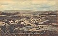 Bird's-eye view c. 1910
 -
 Main Street in 1908
 -
 Thayer's Hotel in 1908
 -
 Town Building and Opera House in 1908


Sites of interest
.jpg)
- Bronze statue of Eleanor H. Porter's creation, Pollyanna. Downtown; unveiled 2002[7]
- Kilburn Brothers Building – where stereo view cards were made
- The Riverwalk and Covered Bridge[8]
- Downtown Historical Walk (marked by plaques on or near various buildings along Main Street)[9]
- The site of punk icon GG Allin's grave.[10]
On the National Register of Historic Places
- Littleton Opera House[11][12]
- United States Post Office and Courthouse–Littleton Main
- Edward H. Lane House
- Thayer's Hotel
- Littleton Community House & Annex
Transportation
The center of Littleton is accessible from three exits of Interstate 93, and a fourth exit serves the western end of town near the Vermont border. U.S. Route 302 runs east–west through the town center as its Main Street. As of January 2006 Littleton is also served by a public transportation bus route[13] connecting with Whitefield and Lancaster.
Education
The municipality is in the Littleton School District,[14] which operates Littleton High School.
Notable people
- Ann E. Bailie (born 1935), NASA mathematician
- Michael Cryans, member of the Executive Council of New Hampshire
- MLBteams
- governor of New Hampshire
- Geoffrey Hendricks (1931–2018), artist associated with Fluxus
- Erin Hennessey (born 1976), state senator
- Benjamin W. Kilburn (1827–1909), machinist, veteran, photographer, stereoscopic publisher
- Pollyanna Grows Up
- Melinda Rankin (1811–1888), missionary, teacher, writer
- Tor Seidler (born 1952), children's author[15]
- Elizabeth Rowell Thompson (1821–1899), philanthropist
- Jack Tilton (1951–2017), art dealer[16]
See also
References
- ^ a b c "2021 U.S. Gazetteer Files – New Hampshire". United States Census Bureau. Retrieved November 29, 2021.
- ^ a b "Littleton town, Grafton County, New Hampshire: 2020 DEC Redistricting Data (PL 94-171)". U.S. Census Bureau. Retrieved November 29, 2021.
- ^ Coolidge, Austin J.; John B. Mansfield (1859). A History and Description of New England. Boston, Massachusetts: A.J. Coolidge. pp. 556–557.
coolidge mansfield history description new england 1859.
- ^ "Census of Population and Housing". Census.gov. Retrieved June 4, 2016.
- ^ a b c "Profile of General Population and Housing Characteristics: 2010 Demographic Profile Data (DP-1): Littleton town, Grafton County, New Hampshire". U.S. Census Bureau, American Factfinder. Archived from the original on February 12, 2020. Retrieved February 21, 2013.
- ^ "Selected Economic Characteristics: 2007-2011 American Community Survey 5-Year Estimates (DP03): Littleton town, Grafton County, New Hampshire". U.S. Census Bureau, American Factfinder. Archived from the original on February 12, 2020. Retrieved February 21, 2013.
- ^ "Pollyanna of Littleton, New Hampshire". GoLittleton.com. Retrieved December 10, 2015.
- ^ "Littleton NH Riverwalk". dudasite.com. Retrieved October 2, 2019.
- ^ "About Littleton". littletonareachamber.com. Littleton Area Chamber of Commerce. Retrieved December 18, 2019.
- ^ Music at the Extremes
- ^ "Littleton Opera House". townoflittleton.com. Retrieved October 2, 2019.
- ^ Panetta, Alexander (November 1, 2023). "This U.S. town is considering a ban on all public art". CBC News.
- ^ TheTri-Town Bus [https:// web.archive.org/web/20060502004114/http://www.tccap.org/the_tri-town.htm Archived] 2006-05-02 at the Wayback Machine
- U.S. Census Bureau. Retrieved April 28, 2024. - Text list
- ^ "Tor Seidler". HarperCollins US.
- ^ Grimes, William (May 10, 2017). "Jack Tilton, Art Dealer With an Eye for the New, Dies at 66". New York Times.
External links
Places adjacent to Littleton, New Hampshire | ||||||||||||||||
|---|---|---|---|---|---|---|---|---|---|---|---|---|---|---|---|---|
| ||||||||||||||||
 | ||||
| Towns |
| |||
| Township | ||||
| CDPs | ||||
Other villages | ||||
| ||||
| Authority control databases: Geographic |
|---|