
Mattupetty Dam
| Mattupetty Dam മാട്ടുപെട്ടി അണക്കെട്ട് | |
|---|---|
 | |
 Location of Mattupetty Dam മാട്ടുപെട്ടി അണക്കെട്ട് in India  Mattupetty Dam (Kerala) Mattupetty Dam (India) | |
| Location | Munnar, Kerala, India |
| Coordinates | 10°06′22″N 77°07′26″E / 10.106°N 77.124°E |
| Construction began | 1949 |
| Opening date | 1953 |
| Construction cost | ₹2.2 crore (US$280,000) |
| Operator(s) | Government of Kerala |
| Reservoir | |
| Creates | Mattupetty |
| Total capacity | 55.4 Million Cubic Meter |
| Catchment area | 105 Square kilometer |
| Surface area | 323.75 Hectare |
| Power Station | |
| Hydraulic head | 46.6 meter |

Mattupetty Dam (Madupetty Dam), near
Idukki District. The large amount of perennially available water allows wild animals and birds to flourish.[1]
Construction of the dam was led by E.U. Philipose, Superintending Engineer, Kerala State Electricity Board. [Paravur
.
Specifications
- Latitude : 10⁰ 06′ 23 ” N
- Longitude: 77⁰ 07′ 26” E
- Panchayath : Madupetty
- Village : KDH Village
- District : Idukki
- River Basin : Muthirapuzha
- River : Muthirapuzha
- Release from Dam to river : Muthirapuzha
- Type of Dam : Free-Fall Gravity
- Construction : Rebar-Reinforced Concrete
- Classification : HH ( High Height)
- Full Reservoir Level ( FRL): EL 1599.59 m
- Full Reservoir Level ( FRL) : EL 1599.59 m
- Storage at FRL : 55.23 Mm3
- Height from deepest foundation : 83.35 m
- Length : 237.74 m
- Spillway : Ogee type- 3 Nos. Radial gates, each of size 6.70 x 4.95 m [2]
Munnar is located near the confluence of the mountain streams of Muthirappuzha River, Chanduvarai River and Kundale River.
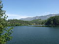
The reservoir is also known to be one of the visiting grounds of elephants in the region.
Gallery
-
 Maduppetty dam
 -
 Munnar Dam
 -
 Munnar Dam
 -
 Munnar dam Panoramic view
 -

-

-

-
-
 Munnar Dam entrance


See also
References
- ^ "Mattupetty Dam". District Tourism Promotion Council, Idukki.
- ^ "MADUPETTY DAM". KSEB Dam Safety Organisation.
External links
Wikimedia Commons has media related to Mattupetty Dam.
- Mattupetti small hydro electric project on YouTube, Kerela State Electricity Board Ltd.
This article related to a location in Idukki district, Kerala, India is a stub. You can help Wikipedia by expanding it. |
This article about a dam, floodgate or canal in India is a stub. You can help Wikipedia by expanding it. |