
Chembra Peak
| Chembra Peak | |
|---|---|
| Parent range | Western Ghats |
| Climbing | |
| Easiest route | Hike |
Chembra Peak (Chembra Mala) is a mountain in the state of
.Visits to the peak[3] are organized by the "Chempra Peak VSS" under the control of the South Wayanad Forest Development Agency; guides are provided for trekking. Chembra Peak is accessible by foot from Meppadi. The District Tourism Promotion Council provides guides and trekking equipment to tourists for fees. Banasura Sagar Dam and Banasura Hill is also nearby.[4]
Gallery
-
 Lake en route to the top of Chembra Peak
 -
 Top View
 -
 View From Meppadi
 -
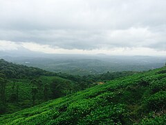 Tea plantations, Chembra peak, Western Ghats Kerala
 -
 Heart shape lake
 -
 Plumeria rubra
 -
 White-bar Bushbrown (Mycalesis anaxias)


-Chembra_-Wayanad.jpg)
References
- ^ "Proceedings of the Chairman, District Disaster Management Authority and the District Magistrate, Wayanad" (PDF). Collectorate, Wayanad. Archived from the original (PDF) on 17 July 2016. Retrieved 16 January 2017.
- ^ "Official Website of Kerala Tourism". Retrieved 1 October 2007.
- ^ "Look out for 'out-of-the-world' adventure at Wayanad's Chembra peak". Onmanorama. 25 September 2022. Retrieved 25 September 2022.
- ^ "Keralam.com site". Archived from the original on 18 November 2007. Retrieved 1 October 2007.
for more details www.youtu.be/CMX-1_uA-zI
External links
Wikimedia Commons has media related to Chembra Peak.
www.youtu.be/CMX-1_uA-zI
| History of Wayanad |
| ||||
|---|---|---|---|---|---|
| Cities | |||||
| Transport |
| ||||
| Education in Wayanad |
| ||||
| Visitor attractions |
| ||||
| Places of worship |
| ||||
| Other topics | |||||