
Vypin
9°58′26″N 76°14′38″E / 9.974°N 76.244°E
Vypin (
Vypin | |
|---|---|
Island | |
UTC+5:30 (IST ) |

The island is about 27 kilometres (17 mi) long and is connected to mainland Kochi by a series of bridges known as the
Development
At far the northern tip of Vypin, is home to the Munambam Fishing Harbour, the largest fishing harbour in Kochi. Puthuvype has become the major industrial hub in Kerala and the fastest growing city suburb due to the SPM project run by
There are ten lighthouses in Kerala, one of which is situated at Puthuvype Beach and is the tallest in Kerala
India's first international container trans-shipment terminal (ICTT) in the Special Economic Zone at Vallarpadam Island, designed to handle the largest container ships, was opened by then Prime Minister Manmohan Singh on February 11, 2011.
There are regular boat services from
Vypin is now a fast-developing suburb of Kochi City. Today, all the basic infrastructure of modern living is available in Vypin. Travellers from North Kerala can use the Vypin–Munambam state highway to reach Ernakulam.
History
The island was formed in 1341 following a heavy flood.
Villages of Vypin
- Cherai
- Edavanakkad
- Elamkunnapuzha
- Fort Vypin
- Kuzhuppilly
- Malippuram
- Munambam
- Murikumpadam
- Nayarambalam
- Nedungad
- Njarackal
- Ochanthuruth
- Pallippuram
- Perumpilly
- Puthuvype
-
 Nedungad
 -
 Cricket at Puthyvypin Beach
 -
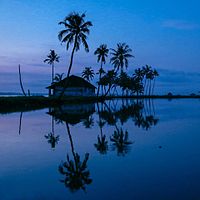
 Vembanad Kayal
 -
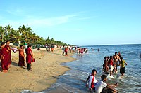 Cherai Beach
 -
 Pallipuram Fort
 -
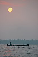 Sunrise at Veeranpuzha


See also
- 1982 Vypeen hooch tragedy
- Mulavukad Grama Panchayat
- Njarackal
External links
Areas of Kochi | ||||||||||||||||
|---|---|---|---|---|---|---|---|---|---|---|---|---|---|---|---|---|
| ||||||||||||||||