
Mine, Yamaguchi
Mine
美祢市 | |
|---|---|
 Karst landscape of Akiyoshidai | |
 Flag  Emblem | |
 Location of Mine in Yamaguchi Prefecture | |
 | |
 Mine Location in Japan | |
| Coordinates: 34°09′47″N 131°12′30″E / 34.16306°N 131.20833°E | |
| Country | Japan |
| Region | Chūgoku (San'yō) |
| Prefecture | Yamaguchi |
| Government | |
| • Mayor | Yōji Shinoda (since April 2020) |
| Area | |
| • Total | 472.64 km2 (182.49 sq mi) |
| Population (April 1, 2023) | |
| • Total | 21,919 |
| • Density | 46/km2 (120/sq mi) |
| Time zone | UTC+09:00 (JST) |
| City hall address | 326-1 Higashi-bun, Ōmine-chō, Mine-shi, Yamaguchi-ken 759-2292 |
| Climate | Cfa |
| Website | Official website |
| Symbols | |
| Flower | Cherry blossom |
| Tree | Live oak |

Mine (美祢市, Mine-shi) is a city located in Yamaguchi Prefecture, Japan. As of 1 April 2023[update], the city had an estimated population of 21,919 in 10661 households and a population density of 46 persons per km2.[1] The total area of the city is 1,472.64 square kilometres (568.59 sq mi).
Geography
San'yō-Onoda is located in the southwestern part of Yamaguchi Prefecture. It is long in the north-south direction and has a fan shape that opens to the Seto Inland Sea. The Asa River flows from the north to the central area, and the Ariho River flows from the northeast to the east, flowing south into the Seto Inland Sea. The city hall is located on the west bank of the Ariho River mouth.
Neighbouring municipalities
Yamaguchi Prefecture
Climate
Mine has a humid subtropical climate (Köppen climate classification Cfa) with hot summers and cool winters. Precipitation is significant throughout the year, but is much higher in summer than in winter. The average annual temperature in Mine is 13.9 °C (57.0 °F). The average annual rainfall is 2,003.3 mm (78.87 in) with July as the wettest month. The temperatures are highest on average in August, at around 25.2 °C (77.4 °F), and lowest in January, at around 3.0 °C (37.4 °F).[2] The highest temperature ever recorded in Mine was 35.6 °C (96.1 °F) on 26 July 2018; the coldest temperature ever recorded was −10.1 °C (13.8 °F) on 3 February 2012.[3]
| Climate data for Akiyoshidai, Mine (1991−2020 normals, extremes 1977−present) | |||||||||||||
|---|---|---|---|---|---|---|---|---|---|---|---|---|---|
| Month | Jan | Feb | Mar | Apr | May | Jun | Jul | Aug | Sep | Oct | Nov | Dec | Year |
| Record high °C (°F) | 15.9 (60.6) |
21.0 (69.8) |
23.8 (74.8) |
28.8 (83.8) |
31.3 (88.3) |
31.9 (89.4) |
35.6 (96.1) |
35.1 (95.2) |
33.5 (92.3) |
29.2 (84.6) |
26.1 (79.0) |
20.4 (68.7) |
35.6 (96.1) |
| Mean daily maximum °C (°F) | 7.3 (45.1) |
8.6 (47.5) |
12.3 (54.1) |
17.9 (64.2) |
22.4 (72.3) |
26.0 (78.8) |
28.6 (83.5) |
29.9 (85.8) |
25.9 (78.6) |
20.8 (69.4) |
15.4 (59.7) |
9.8 (49.6) |
18.7 (65.7) |
| Daily mean °C (°F) | 3.0 (37.4) |
4.0 (39.2) |
7.4 (45.3) |
12.5 (54.5) |
16.9 (62.4) |
20.4 (68.7) |
24.2 (75.6) |
25.2 (77.4) |
21.3 (70.3) |
15.8 (60.4) |
10.3 (50.5) |
5.2 (41.4) |
13.9 (56.9) |
| Mean daily minimum °C (°F) | −1.3 (29.7) |
−0.6 (30.9) |
2.9 (37.2) |
7.6 (45.7) |
12.0 (53.6) |
16.5 (61.7) |
20.9 (69.6) |
21.7 (71.1) |
17.6 (63.7) |
11.4 (52.5) |
5.6 (42.1) |
0.8 (33.4) |
9.6 (49.3) |
| Record low °C (°F) | −9.5 (14.9) |
−10.1 (13.8) |
−5.7 (21.7) |
−1.2 (29.8) |
3.7 (38.7) |
7.6 (45.7) |
14.0 (57.2) |
14.4 (57.9) |
6.2 (43.2) |
0.6 (33.1) |
−3.2 (26.2) |
−7.1 (19.2) |
−10.1 (13.8) |
| Average precipitation mm (inches) | 95.5 (3.76) |
91.4 (3.60) |
147.7 (5.81) |
159.6 (6.28) |
187.4 (7.38) |
283.0 (11.14) |
344.0 (13.54) |
204.4 (8.05) |
196.5 (7.74) |
106.3 (4.19) |
91.3 (3.59) |
84.0 (3.31) |
2,003.3 (78.87) |
| Average precipitation days (≥ 1.0 mm) | 12.8 | 11.4 | 12.5 | 10.6 | 9.9 | 12.4 | 11.6 | 9.7 | 10.2 | 8.5 | 9.5 | 11.7 | 130.8 |
| Mean monthly sunshine hours | 102.7 | 112.5 | 155.4 | 180.6 | 204.3 | 133.0 | 143.2 | 183.9 | 154.1 | 170.6 | 138.0 | 109.1 | 1,787.4 |
| Source: Japan Meteorological Agency[2][3] | |||||||||||||
Demographics
Per Japanese census data, the population of Mine in 2020 is 23,247 people.[4] Mine has been conducting censuses since 1920.
| Year | Pop. | ±% |
|---|---|---|
| 1920 | 41,979 | — |
| 1925 | 42,587 | +1.4% |
| 1930 | 43,302 | +1.7% |
| 1935 | 42,782 | −1.2% |
| 1940 | 47,623 | +11.3% |
| 1945 | 57,936 | +21.7% |
| 1950 | 60,044 | +3.6% |
| 1955 | 61,870 | +3.0% |
| 1960 | 60,322 | −2.5% |
| 1965 | 52,366 | −13.2% |
| 1970 | 43,741 | −16.5% |
| 1975 | 37,670 | −13.9% |
| 1980 | 36,907 | −2.0% |
| 1985 | 35,730 | −3.2% |
| 1990 | 33,532 | −6.2% |
| 1995 | 32,396 | −3.4% |
| 2000 | 31,546 | −2.6% |
| 2005 | 29,839 | −5.4% |
| 2010 | 28,645 | −4.0% |
| 2015 | 26,159 | −8.7% |
| 2020 | 23,247 | −11.1% |
| Mine population statistics[4] | ||
Geology
The plateau consists of uplifted reef limestones of Paleozoic age, which were thickened by overfolding during the Akiyoshidai orogenic movement. Subsequent erosion has created an undulating karst landscape dimpled with many dolines and countless limestone pinnacles up to two meters in height. Beneath the surface lie hundreds of caves, a few of them quite significant geologically.
Numerous fossils of
The area around Akiyoshidai was once heavily forested about 500,000 years ago. In the
History
The area of Mine was part of ancient
Government
Mine has a
Economy
Mine was noted from ancient times for its copper mines with the
Tourism centered on Akiyoshidai Quasi-National Park is also a major component of the local economy.
Education
Mine has 12 public elementary school and six public junior high schools operated by the city government, and one public high school operated by the Yamaguchi Prefectural Board of Education. There are also one private high school.
Transportation
Railway
- Atsu - Shirōgahara - Minami-Ōmine - Mine - Shigeyasu - Ofuku
Highways
 Chugoku Expressway
 National Route 316
 National Route 435
 National Route 490
Local attractions
- Akiyoshidai Quasi-National Park, which includes the Akiyoshidai (秋吉台, Akiyoshi plateau) and Japan's longest cave, the Akiyoshido (秋芳洞), the latter of which is designated a Special Natural Monument. Akiyoshidai is served by a natural history museum, visitor center, rest house, youth hostel and park headquarters building, and is traversed by a scenic roadway and several walking trails. Events include a fireworks festival in July, a “Karst Walk” in November, and an annual burning off of dry grasses in February called “Yamayaki”. Akiyoshidai Quasi-National Park is situated within the Mine-Akiyoshidai Karst Plateau Geopark.
- Emperor Hirohito on May 30, 1926 when he was still crown prince. This spacious cave is up to 100 meters wide and has 8.79 kilometers of passages, making it the longest in Japan and one of the longest in Asia. At the present time an approximately one-kilometer-long section of the cave is open to the public as a sightseeing course, with a walkway and bridge system, entering at the cave's lowest point and exiting via an artificial elevator. This portion of the cave is also well decorated with a variety of large and colorful speleothems.
- Mine-Akiyoshidai Karst Plateau Geopark
-
 Akiyoshi-do cave
 -
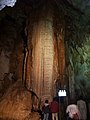 Stalactite called "Gold Column"
 -
 View of Karst landscape


Notable people from Mine
- governorof Yamaguchi Prefecture
- Mayu Iwatani, acclaimed professional wrestler with World Wonder Ring Stardom and Ring of Honor
- Aum Shinrikyo (Sakamoto family murder and Tokyo subway sarin attack)
References
- ^ "Mine City official statistics" (in Japanese). Japan.
- ^ a b 気象庁 / 平年値(年・月ごとの値). JMA. Retrieved May 25, 2022.
- ^ a b 観測史上1~10位の値(年間を通じての値). JMA. Retrieved May 25, 2022.
- ^ a b Mine population statistics
External links
 Media related to Mine, Yamaguchi at Wikimedia Commons
- Mine City official website (in Japanese)
- Yamaguchi Prefecture official website Archived 2011-09-28 at the Wayback Machine (in English)
| Core city | ||
|---|---|---|
| Cities | ||
| Districts | ||
| International | |
|---|---|
| National | |
| Geographic | |