
Minuteman Missile National Historic Site
| Minuteman Missile National Historic Site | |
|---|---|
U.S. National Historic Site | |
 A view of the silo from above | |
| Area | 1.6 acres (0.65 ha) |
| NRHP reference No. | 01000275[3] |
| Added to NRHP | November 29, 1999 |
 .jpg) |
| Southwestern South Dakota |
|---|
| Sculptures |
| Geologic and natural history |
| Mountains |
| Caves |
| Forests and wildernesses |
|
| Lakes |
| Scenic byways |
| Historic sites |
This article needs additional citations for verification. (April 2022) |
The Minuteman Missile National Historic Site is an American
Facilities
This national historic site consists of three facilities: a visitor center and two significant
The silo, known as launch facility Delta Nine (D-09) was constructed in 1963. It occupies 1.6 acres (6,000 m2) nearly one-half mile (800 m) southwest of Interstate 90 at Exit 116 and six miles (9.7 km) from the town of Wall, South Dakota, in eastern Pennington County. It consists of an underground launch tube ("missile silo") 12 feet (3.7 m) in diameter and 80 feet (24.4 m) deep, made of reinforced concrete with a steel-plate liner. An unarmed missile is on display inside. The launch tube's 90-ton cover has been rolled partly away and welded to the rails it rides on. The launch tube was then covered with a glass viewing enclosure. Not only does this permit visitors to see the missile, it enables Russian satellites to verify that the site is not operational, and hence in compliance with the Strategic Arms Reduction Treaty. Because the only way to get to the underground part of the site is by a ladder 30 feet (9.1 m) long, tours are not conducted underground for safety reasons. Visitors can conduct self-guided tours of the site during the day by calling a number on their cell phones and walking around the site, listening to the description of various points over the phone.
The launch control facility, known as Delta One (D-01), is about 10.5 miles (16.9 km) away, to the east-southeast in northwestern Jackson County. It occupies approximately six acres (24,000 m2) about 1.7 miles (2.7 km) north of I-90 at Exit 127. It consists of an above-ground building containing a kitchen, sleeping quarters, offices and life-support equipment. Below this building is the actual launch control center, buried 31 feet (9.4 m) deep, connected to the building by an elevator. Guided tours are conducted underground here, but are limited to six people at a time due to the very small underground launch control center ("capsule") and are a half-hour long. Self-guided tours are not possible here; the gate for the fence around D-01 is always locked, just like it was when it was an active launch control facility.
History
The complex, one of six located in the central United States, was built as a deterrent to a nuclear first strike by the Soviet Union. By placing missiles underground in widely separated locations, it was hoped that regardless of the size of a Soviet missile attack, enough US missiles would survive to ensure devastation on the aggressor nation. The Minutemen in this complex remained on alert for nearly 30 years until the wing was deactivated following the signing of the Strategic Arms Reduction Treaty (START) by President George Bush and Soviet leader Mikhail Gorbachev in 1991. Under the terms of the treaty, the missiles in this complex were removed from their silos, and in 1994 the 44th Missile Wing was deactivated. All sites in the complex, except D-01 and D-09, have been destroyed.[4]
D-01 and D-09 were candidates for becoming a national historic site because they were both close to a major road (
The Minuteman Missile National Historic Site Boundary Modification Act (S. 459; 113th Congress) added about 29 acres (12 ha) of land to the park in 2013, tripling its size to include a visitor facility. Most of it was transferred from the adjacent Buffalo Gap National Grassland.[5]
Gallery
-
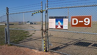 D-9 silo
 -
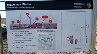 D-9 silo map
 -
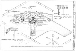 D-9 Axonometric Site Plan
 -
 44th Strategic Missile Wing squadron silo locations
 -
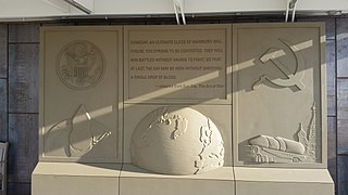 Quote by Sun Tzu
 -
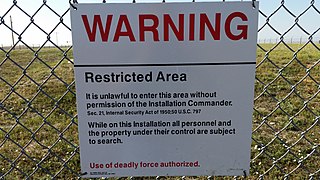 Warning sign
 -
 Entry gate to the Delta-01 launch control facility
 -
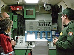 Control Room for Delta Flight Launch facility
 -
 Interior of the command module for Delta Flight
 -
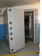 Blast door
 -
 Blast door, front
 -
 Blast door, edge view


See also
- List of museums in South Dakota
- Ronald Reagan Minuteman Missile State Historic Site
- Titan Missile Museum
- Quebec-One Missile Alert Facility
- Strategic Air and Space Museum– Museum collection includes Minuteman II, Minuteman III, and Titan II re-entry vehicle shrouds and launch control systems on display.
- Strategic missile forces museum in Ukraine – Similar museum in the former Soviet Union
References
- ^ "Listing of acreage – December 31, 2020" (XLSX). Land Resource Division, National Park Service. Retrieved 2012-05-13. (National Park Service Acreage Reports)
- ^ "NPS Annual Recreation Visits Report". National Park Service. Retrieved 2021-04-25.
- ^ "National Register Information System". National Register of Historic Places. National Park Service. July 9, 2010.
- ^ a b c "Minuteman Missile National Historic Site". National Park Service. Retrieved 2012-11-09.
- ^ "S. 459 – Summary". United States Congress. Retrieved 13 September 2013.
External links
- National Park Service, Minuteman Missile National Historic Site
- Minuteman Missile National Historic Site: Protecting a Legacy of the Cold War , a National Park Service Teaching with Historic Places (TwHP) lesson plan
- Aviation: From Sand Dunes to Sonic Booms, a National Park Service Discover Our Shared Heritage Travel Itinerary
- Historic American Engineering Record (HAER) No. SD-50, "Ellsworth Air Force Base, Delta Flight, 10 mile radius around Exit 127 off Interstate 90, Interior vicinity, Jackson County, SD"
- HAER No. SD-50-A, "Ellsworth Air Force Base, Delta Flight, Launch Control Facility, County Road CS23A, North of Exit 127, Interior vicinity, Jackson County, SD", the Delta launch control center
- HAER No. SD-50-C, "Ellsworth Air Force Base, Delta Flight, Launch Facility, On County Road T512, south of Exit 116 off I-90, Interior vicinity, Jackson, SD", the Delta-Nine silo
| Historic districts |  | |
|---|---|---|
| Historic properties |
| |

| International | |
|---|---|
| National | |