
Black Hills National Forest
| Black Hills National Forest | |
|---|---|
 The Needles from Black Elk Peak in Black Hills National Forest | |
 | |
| Location | South Dakota and Wyoming, U.S. |
| Nearest city | Rapid City, South Dakota |
| Coordinates | 43°56′11″N 103°43′40″W / 43.93639°N 103.72778°W |
| Area | 1,253,308 acres (5,071.96 km2)[1] |
| Established | February 22, 1897[2] |
| Governing body | U.S. Forest Service |
| Website | Black Hills National Forest |
Black Hills National Forest is located in southwestern
Predominantly
History

 .jpg) |
| Southwestern South Dakota |
|---|
| Sculptures |
| Geologic and natural history |
| Mountains |
| Caves |
| Forests and wildernesses |
|
| Lakes |
| Scenic byways |
| Historic sites |
After a series of devastating
The Black Hills National Forest provided the Capitol Christmas Tree in 1997, a 63-foot white spruce.[8]
Geography
The forest is located in parts of seven counties in South Dakota and Wyoming. In descending order of forestland area they are Pennington, Custer, Lawrence, Crook, Fall River, Meade, and Weston counties. (Crook and Weston are the only counties in Wyoming; only one-seventh of the forest acreage lies in Wyoming.) [9]
The Forest is located immediately west and south of Rapid City and can be accessed from Interstate 90. The forest headquarters is located in Custer, South Dakota. The Peter Norbeck National Scenic Byway passes through the forest in proximity to Mount Rushmore and along with the Spearfish Canyon National Forest Scenic Byway, provide two of the more scenic drives in the Country.
Although surrounded by Black Hills National Forest, both
The Black Hills National Forest encompasses three distinct mountain ranges: the Black Hills and the Elk Mountains in South Dakota as well as the Bear Lodge Mountains in Wyoming. The Black Hills are by far the largest of the three ranges.
Flora and fauna
While ponderosa pine is the most common tree species found in the forest,
Recreation
30
trails and hundreds of miles of equestrian trails provide access to more remote destinations and to the summit of Black Elk Peak. With over 5,000 miles (8,000 km) of Forest system roads, the Forest is also a haven for motorized travel.Gallery
-
 The Bear and Beaver Gulches Botanical Area
 -
 Hikers on the Deerfield Trail
 -
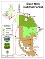 A map of the Ranger Districts
 -
 The Cold Springs Schoolhouse in Custer County
 -
 Lake Dorn circa 1940
.jpg)


References
- ^ "Land Areas of the National Forest System" (PDF). U.S. Forest Service. January 2012. Retrieved June 30, 2012.
- ^ "The National Forests of the United States" (PDF). ForestHistory.org. Retrieved July 30, 2012.
- ^ "USFS Ranger Districts by State" (PDF). Archived from the original (PDF) on 2012-01-19. Retrieved 2009-05-17.
- ^ "Feature Detail Report for: Harney Peak". Geographic Names Information System. United States Geological Survey, United States Department of the Interior. Retrieved March 12, 2010.
- ^ Peters, Gerhard; Woolley, John T. "Grover Cleveland: "Proclamation 392 - Withdrawal of Lands for the Black Hills Forest Reserve, South Dakota," February 22, 1897". The American Presidency Project. University of California - Santa Barbara.
- ^ Peters, Gerhard; Woolley, John T. "William McKinley: "Proclamation 425 - Enlarging the Black Hills Forest Reserve in the States of South Dakota and Wyoming," September 19, 1898". The American Presidency Project. University of California - Santa Barbara.
- ^ Raymond J. DeMallie, Jr., 2006.
- ^ Staff, NewsCenter1 (2021-12-02). "Throwback Thursday: 1997 U.S. Capitol Christmas tree came from the Black Hills". NewsCenter1.tv. Retrieved 2023-12-20.
{{cite web}}: CS1 maint: numeric names: authors list (link) - ^ Table 6 - NFS Acreage by State, Congressional District and County - United States Forest Service - September 30, 2007
External links
 Black Hills National Forest travel guide from Wikivoyage
- "Black Hills National Forest". U.S. Forest Service.