
North Downs
| North Downs | |
|---|---|
 The North Downs near the entrance to the Channel Tunnel in Folkestone | |
| Highest point | |
| Peak | Botley Hill |
| Elevation | 270 m (890 ft) |
| Naming | |
| Etymology | Old English dūn, meaning 'hill' |
| Geography | |
| Country | England (United Kingdom) |
| Region | Surrey, Kent |
| Parent range | Southern England Chalk Formation |
| Geology | |
| Orogeny | Alpine orogeny |
| Age of rock | Cretaceous |
| Type of rock | chalk |
The North Downs are a ridge of
The highest point in the North Downs is
Etymology
'Downs' is from Old English dun, meaning, amongst other things, "hill". The word acquired the sense of "elevated rolling grassland" around the 14th century.[2] The name contains "North" to distinguish them from a similar range of hills – the South Downs – which runs roughly parallel to them but some 50 km (31 mi) to the south.
Geography


The narrow spine of the
The Downs are highest near the Kent–Surrey border, often reaching heights in excess of 200 m (660 ft) above sea level at the crest of the escarpment. The highest point is
The ridge of the North Downs is intersected by the valleys of a series of rivers: the
Leith Hill (the highest point in Surrey) is sometimes incorrectly referred to as part of the North Downs, but it is located on the parallel Greensand Ridge[7] and does not consist of chalk.[8]
Geology
Rock types
The Downland of the North Downs consists of distinct lithostratigraphic units (the types of strata, the names of which are always capitalised):
- Shallow layers of sand and gravel are associated with areas of heathland, including at Headley and Netley Heaths in Surrey. These deposits have their origin in the Quaternary and indicate the position of the sea shore during this period.[9]
- Clay-with-Flints, a sandy clay with many flints is found on higher ground. The origins of this layer are uncertain, however the clay is thought to have been formed during several periods of glaciation and was produced by cryoturbation and decalcification of the chalk.[10] This hypothesis is supported by the presence of flint, which is also found in the underlying strata.[10][11]

- The The chalk of the North Downs is generally divided into three distinct stata: The Upper Chalk, which has many flints; the Middle Chalk, with fewer flints; and the Lower Chalk or Coombe Rock, greyish, with few flints. The chalk is most commonly exposed on slopes or as cliffs, where the overlying acidic strata have been quarried or washed away. The buried upper surface of the chalk beneath the acidic strata is often eroded into pipes, gulleys and pinnacles, sometimes visible in road cuttings and quarries.
- The Upper GreensandFormation, a whitish, limy sandstone, often used for building, for which it has been mined from beneath the chalk (for example from the Godstone Baby Mines). The Upper Greensand of the North Downs is a thin bed of one or two metres thickness, and it is rarely visible at the surface (it is much thicker elsewhere).
Wealden uplift and erosion
Following the Cretaceous, the sea covering the south of England began to retreat and the land was pushed higher. The Weald (the area covering modern day south Surrey, south Kent and north Sussex) was lifted by
Chalk is a relatively soft rock that may be eroded or weathered in a number of different ways. It is porous, absorbing up to 20% of its dry weight in water,[15] and is therefore highly susceptible to weathering by freeze-thaw action, which may occur over repeated annual or diurnal cycles. This frost weathering produces a mix of rubble and viscous mud, which may be washed downhill, further eroding the landscape (a process known as solifluction).[16] Since chalk contains a very high percentage of calcium carbonate, it can be dissolved by both groundwater[16] and rainwater.[17]
Across much of the North Downs, the chalk dips below the London Clay at a relatively shallow angle (c. 18° near Dorking), however at the far west of the range, local faulting has produced a much steeper angle (up to 55°), resulting in the distinctive Hog's Back between Farnham and Guildford.[18]
Ecology
.jpg)
.jpg)
The North Downs support several important habitats including chalk grassland, scrub, woodland and chalk heath.
Chalk grassland
The nationally rare
.jpg)
.jpg)
Chalk grassland also supports a rich fauna, particularly insects. Notable butterfly species include
Quarries and chalk cliffs
On the summit of the cliffs between
Woodland
Woodland was far more extensive on the North Downs prior to human clearance 5000 to 4000 years ago.[1] Fragments still remain particularly where the layer of clay-with-flints overlying the chalk has inhibited clearance.[21] Where this is the case species such as pedunculate oak predominate, although much woodland has been replanted with conifer and sweet chestnut.[1]

Calcareous woodland occurs on thin soils where chalk is close to the surface. These conditions are most often found on the escarpment of the North Downs and on valley slopes, but may also occur on the plateau of the dip slope. Calcareous woodland is typically dominated by beech, hornbeam, yew and ash. Box Hill has one of the largest areas of native box woodland in England. One notable species characteristic of calcareous woodland is the nationally scarce lady orchid, which is found in more than 100 sites on the Kent stretch of the North Downs, but is confined to just two sites elsewhere in the UK.[22]
Scrub
Although its spread is often considered undesirable, scrub provides valuable habitat for a range of invertebrates, including the Roman snail, rufous grasshopper and the dark green fritillary.
Chalk heath
In Surrey, superficial deposits from the Quaternary are found overlying the chalk. These sands and gravels indicate the position of a former sea shore. Where these deposits occur, they are thin and the chalk also comes to the surface in the same areas (e.g. Headley Heath on the north east side of Box Hill), allowing acid-loving plants to thrive alongside those that prefer alkaline conditions, producing the rare chalk heath habitat.
History
Worked flints and human and animal remains dating from the
In about 3000 BC the emergence of
Agriculture and industry

The landscape of the Downs has been greatly shaped by man. There has been
There is plenty of evidence of chalk extraction on the Downs, particularly along the scarp slope. Oil has been drilled at the foot of the Downs in several locations in Surrey. The Kent Coalfield was established in the late 19th century after coal was found in 1890. Four successful collieries continued to be worked through much of the 20th century: Betteshanger, Snowdown, Tilmanstone and Chislet; Bettershanger was the last to close in 1989. The east to west ridge of the Downs has provided a natural transport route for centuries. Much of the historic Pilgrims' Way still survives at the foot of the scarp slope, and this has been joined much more recently by the M20 motorway. The scarp slope has also been used for fortification; many examples of this still exist, such as Thurnham Castle and on Castle Hill, Folkestone Castle Hill near Folkestone.
Places of interest
Many beauty spots on the North Downs are owned by the
Hills
The topography of the North Downs means there are relatively few summits with topographic prominence. Below is a list of summits on the North Downs which are more than 180 metres in height with 30 metres of topographic prominence (a commonly used threshold in Britain). The summits are arranged in order along the range, from west to east.
| Hill | Height (m) | Prominence (m) | OS grid reference |
|---|---|---|---|
| Dunley Hill | 227 | 105 | TQ104490 |
| Box Hill | 224 | 53 | TQ203517 |
| Reigate Hill | 235 | 100 | TQ255520 |
| White Hill | 233 | 30 | TQ328532 |
| Gravelly Hill | 237 | 64 | TQ337532 |
| Winders Hill | 236 | 47 | TQ353540 |
| Botley Hill | 270 | 209 | TQ387551 |
| Wrotham Hill | 235 | 129 | TQ593600 |
| Detling Hill | 200 | 163 | TQ804586 |
| West Down | 186 | 73 | TR091453 |
Tolsford Hill
|
183 | 61 | TR159386 |
| Cheriton Hill | 188 | 150 | TR197396 |
Photo gallery
-
 The North Downs at theWye DownsNational Nature Reserve
 -
 The North Downs above Hollingbourne.
 -

-
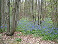 Bluebells at Ranscombe Farm
 -
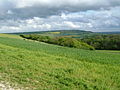 Looking East, typical downland scenery in the Medway Gap, Ranscombe Farm
 -

-
 Woodland on the North Downs at the Hucking Estate
 -
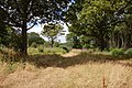
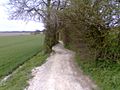 Typical chalk downland trail near Hollingbourne
 -
 A modern metal trail marker near Harrietsham
 -
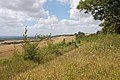
 A view South across the Kent Weald from the North Downs Way near Detling

,_Kent,_UK.jpg)


See also
- Chalk figures in the United Kingdom
- Geology of the United Kingdom
- North Downs Way
- Downland
References
- ^ a b c d e "North Downs Natural Area profile" (PDF). English Nature. August 1997. Archived from the original (PDF) on 27 October 2015. Retrieved 12 September 2007.
- ^ "d | Origin and history of d by Online Etymology Dictionary". Etymonline.com. Archived from the original on 14 May 2011. Retrieved 16 September 2017.
- ^ The Mountains of England of Wales, Botley Hill, http://www.hill-bagging.co.uk/mountaindetails.php?qu=Ma&rf=3686 Archived 3 May 2014 at the Wayback Machine, Retrieved 4 March 2012
- ^ a b Bathurst 2012, pp. 82–82
- ^ Simon Edwardes (2001). "County Tops". The Mountains of England and Wales. Archived from the original on 3 May 2014. Retrieved 20 April 2014.
- ^ The Mountains of England and Wales, Westerham Heights, http://www.hill-bagging.co.uk/mountaindetails.php?qu=Ma&rf=5503 Archived 3 May 2014 at the Wayback Machine, Retrieved 4 March 2012
- ^ Gallois RW and Edmunds FH (1965) British Regional Geology: The Wealden District (4th Ed.) published by the Natural Environment Research Council: Institute of Geological Sciences
- ^ Bennison & Wright 1969, p. 321
- ^ Chapman & Young 1979, p. 26
- ^ a b Gallois, RW (2009). "The origin of the Clay-with-flints: the missing link". Geoscience in South-West England. 12: 153–161.
- ^ Anon. "Clay-with Flints formation". The BGS Lexicon of Named Rock Units. BGS. Archived from the original on 9 September 2017. Retrieved 3 May 2017.
- .
- ISBN 0-11-884078-9.
- ^ Chapman & Young 1979, pp. 15–29
- .
- ^ a b Lester, DE (2015). "Geomorphology of the Mole Valley" (PDF). Mole Valley Geological Society. Archived (PDF) from the original on 16 November 2017. Retrieved 17 July 2020.
- S2CID 129120488.
- .
- ^ "What's special about chalk grassland?". National Trust. National Trust. Archived from the original on 25 October 2019. Retrieved 25 October 2019.
- ISBN 978-1-9015-0947-2. Archived from the original(PDF) on 13 September 2012.
- ^ ISBN 1-86077-353-2.
- ^ "Britain's Orchids, Lady Orchid". Wild Guides and English Nature. Archived from the original on 3 March 2016. Retrieved 12 September 2007.
- ^ ISBN 978-0-7524-4405-5.
- ^ "Prehistory and The Romans". Guildford Borough. Archived from the original on 22 December 2007. Retrieved 21 February 2008.
Bibliography
- Bathurst, David (2012). Walking the county high points of England. Chichester: Summersdale. ISBN 978-1-84-953239-6.
- Beanse, Alec; Gill, Roger (2011). The London Mobilisation Centres. Hampshire: David Moore. ISBN 978-0954845377.
- Bennison, GM; Wright, AE (1969). The geological history of the British Isles. London: Edward Arnold.
- Brandon, Peter (2005). The North Downs. Chichester: Phillimore. ISBN 978-1860773532.
- Chapman, GM; Young, RHD (1979). Box Hill. Lyme Regis: Serendip. ISBN 0-9504143-1-X.
- Dines, HG; Edmunds, FH; Chatwin, CP; Stubblefield, CJ (1933). The geology of the country around Reigate and Dorking : Explanation of one-inch geological sheet 286, new series. London: British Geological Survey. Archived from the original on 2 January 2021. Retrieved 14 August 2020.
- Tuson, Dan (2007). Kent Downs. Cheltenham: The History Press. ISBN 978-0752444055.
External links
| Unitary authorities | |
|---|---|
| Boroughs or districts | |
| Major settlements (cities in italics) |
|
| Rivers | See: Rivers of Kent |
| Topics |
|