
Ozark, Alabama
Ozark | ||
|---|---|---|
|
FIPS code 01-57648 | | |
| GNIS feature ID | 0152832 | |
| Website | www | |
Ozark is a city in and the county seat of Dale County, Alabama. As of the 2010 census, the population of the city was 14,907.[2]
Ozark is the principal city of the
History
The Ozark area was originally inhabited by the
The first known European settler in Ozark was John Merrick Sr., a veteran of the Revolutionary War, in 1822. In honor of him, the town was named Merricks. It was later changed to Woodshop, which was its name when the town received its post office. The first appearance of the name Ozark was in 1855, when the citizens requested a name change.[6]
The county seat was moved from Newton to Ozark 1870.[6][7]
Ozark is home to four sites listed on the National Register of Historic Places: the Claybank Log Church, the Samuel Lawson Dowling House, the Old Train Depot, and the J. D. Holman House.
Geography
Ozark is located at 31°26′53″N 85°38′31″W / 31.44806°N 85.64194°W (31.448169, -85.642009).
Major highways that run through the city include U.S. Route 231 and Alabama State Routes 27 and 249. US 231 runs northwest to southeast through the city, leading northwest 34 mi (55 km) to Troy and southeast 23 mi (37 km) to Dothan. SR 27 leads east 31 mi (50 km) to Abbeville and southwest 19 mi (31 km) to Enterprise.
According to the U.S. Census Bureau, the city has a total area of 34.5 square miles (89 km2) of which 34.2 square miles (89 km2) is land and 0.2 square miles (0.52 km2) (0.70%) is water.
Climate
According to the Köppen climate classification, Ozark has a humid subtropical climate (abbreviated Cfa).
| Climate data for Ozark, 1991–2020 simulated normals (400 ft elevation) | |||||||||||||
|---|---|---|---|---|---|---|---|---|---|---|---|---|---|
| Month | Jan | Feb | Mar | Apr | May | Jun | Jul | Aug | Sep | Oct | Nov | Dec | Year |
| Mean daily maximum °F (°C) | 59.7 (15.4) |
63.7 (17.6) |
70.9 (21.6) |
77.4 (25.2) |
84.7 (29.3) |
89.2 (31.8) |
90.9 (32.7) |
90.3 (32.4) |
86.9 (30.5) |
79.0 (26.1) |
69.3 (20.7) |
62.1 (16.7) |
77.0 (25.0) |
| Daily mean °F (°C) | 48.9 (9.4) |
52.5 (11.4) |
58.8 (14.9) |
65.5 (18.6) |
73.4 (23.0) |
79.3 (26.3) |
81.1 (27.3) |
80.6 (27.0) |
76.8 (24.9) |
67.6 (19.8) |
57.4 (14.1) |
51.3 (10.7) |
66.1 (19.0) |
| Mean daily minimum °F (°C) | 37.9 (3.3) |
41.2 (5.1) |
46.9 (8.3) |
53.6 (12.0) |
62.2 (16.8) |
69.3 (20.7) |
71.4 (21.9) |
70.9 (21.6) |
66.6 (19.2) |
56.3 (13.5) |
45.5 (7.5) |
40.6 (4.8) |
55.2 (12.9) |
| Average precipitation inches (mm) | 5.05 (128.21) |
4.94 (125.41) |
5.19 (131.72) |
4.83 (122.73) |
3.40 (86.33) |
5.21 (132.32) |
6.23 (158.32) |
5.22 (132.60) |
4.32 (109.73) |
3.12 (79.17) |
4.05 (102.82) |
5.29 (134.27) |
56.85 (1,443.63) |
| Average dew point °F (°C) | 40.3 (4.6) |
43.2 (6.2) |
47.3 (8.5) |
54.0 (12.2) |
61.5 (16.4) |
68.9 (20.5) |
71.6 (22.0) |
71.2 (21.8) |
67.3 (19.6) |
57.6 (14.2) |
48.2 (9.0) |
43.5 (6.4) |
56.2 (13.5) |
| Source: PRISM Climate Group[9] | |||||||||||||
Demographics
| Census | Pop. | Note | %± |
|---|---|---|---|
| 1880 | 512 | — | |
| 1890 | 1,195 | 133.4% | |
| 1900 | 1,570 | 31.4% | |
| 1910 | 2,229 | 42.0% | |
| 1920 | 2,518 | 13.0% | |
| 1930 | 3,103 | 23.2% | |
| 1940 | 3,601 | 16.0% | |
| 1950 | 5,238 | 45.5% | |
| 1960 | 9,534 | 82.0% | |
| 1970 | 13,555 | 42.2% | |
| 1980 | 13,188 | −2.7% | |
| 1990 | 12,922 | −2.0% | |
| 2000 | 15,119 | 17.0% | |
| 2010 | 14,907 | −1.4% | |
| 2020 | 14,368 | −3.6% | |
| U.S. Decennial Census[10] | |||
2010 census
At the
Of the 6,209 households 26.1% had children under the age of 18 living with them, 43.3% were married couples living together, 17.5% had a female householder with no husband present, and 34.5% were non-families. 30.5% of households were one person and 12.0% were one person aged 65 or older. The average household size was 2.35 and the average family size was 2.91.
The age distribution was 23.1% under the age of 18, 8.4% from 18 to 24, 23.1% from 25 to 44, 28.2% from 45 to 64, and 17.2% 65 or older. The median age was 41.2 years. For every 100 females, there were 90.7 males. For every 100 females age 18 and over, there were 92.6 males.
The median household income was $41,079 and the median family income was $52,061. Males had a median income of $41,513 versus $28,227 for females. The per capita income for the city was $22,103. About 13.6% of families and 18.4% of the population were below the
2020 census
| Race | Num. | Perc. |
|---|---|---|
White (non-Hispanic)
|
8,147 | 56.7% |
Black or African American (non-Hispanic)
|
4,760 | 33.13% |
Native American
|
65 | 0.45% |
Asian
|
151 | 1.05% |
Pacific Islander
|
8 | 0.06% |
Other/Mixed
|
671 | 4.67% |
Latino
|
566 | 3.94% |
As of the 2020 United States census, there were 14,368 people, 5,946 households, and 3,651 families residing in the city.
Education
Ozark is served by the Ozark City Schools. Schools located in the city are Carroll High School (grades 9 through 12), Carroll Career Center (grades 9 through 12), D.A. Smith Middle School (grades 6 through 8), Harry N. Mixon Intermediate School (grades 3 through 5), and Joseph W. Lisenby Primary School (grades k through 2.)
Dale County School District is headquartered in Ozark,[12] but does not include Ozark.[13]
There is one private school in Ozark, Harvest Christian School for K-12.
Post-secondary education is available at Enterprise State Community College's Alabama Aviation Center at Ozark. Programs are offered in aviation maintenance technology.
-
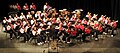 Carroll High School Band 2009
 -
 Carroll High School Marching Band "Pride of the Wiregrass" 2007


Media
Radio stations
Newspaper
- The Southern Star- weekly
Notable people
- Steve Clouse, state representative
- Larry Donnell, tight end for the New York Giants
- Washington Redskins
- Meg McGuffin, Miss Alabama2015
- nose tackle/defensive end, Pittsburgh Steelers
- Byron Mitchell, former super middleweight boxing champion
- Marc Ronan, Major League Baseball catcher
- Tutor-Saliba Corporation
- Josh Savage, professional football player
See also
References
- ^ "2020 U.S. Gazetteer Files". United States Census Bureau. Retrieved October 29, 2021.
- ^ "Geographic Identifiers: 2010 Demographic Profile Data (G001): Ozark city, Alabama". U.S. Census Bureau, American Factfinder. Retrieved October 2, 2015.[dead link]
- ^ "Table 1. Annual Estimates of the Population of Metropolitan and Micropolitan Statistical Areas: April 1, 2000 to July 1, 2009 (CBSA-EST2009-01)". 2009 Population Estimates. United States Census Bureau, Population Division. March 23, 2010. Archived from the original (CSV) on March 26, 2010. Retrieved March 24, 2010.
- US Census Bureau. Retrieved December 14, 2021.
- United States Office of Management and Budget. March 6, 2020. Retrieved September 21, 2020.
- ^ a b Watson, Fred Shelton (1968). Forgotten trails: a history of Dale County, Alabama, 1824–1966. Birmingham, Alabama: Banner Press. p. 288.
- ^ Hoskins Morton, Patricia (December 10, 2010). "Dale County". Encyclopedia of Alabama. Retrieved February 1, 2010.
- ^ "US Gazetteer files: 2010, 2000, and 1990". United States Census Bureau. February 12, 2011. Retrieved April 23, 2011.
- ^ "PRISM Climate Group at Oregon State University". Northwest Alliance for Computational Science & Engineering (NACSE), based at Oregon State University. Retrieved March 15, 2023.
- ^ United States Census Bureau. "Census of Population and Housing". Retrieved June 7, 2014.
- ^ "Explore Census Data". data.census.gov. Retrieved December 17, 2021.
- ^ "Home". Dale County School District. Retrieved July 4, 2022.
202 South Highway 123, Ozark, AL 36360
- U.S. Census Bureau. Retrieved July 4, 2022. - Text list- "Fort Rucker School District" refers to DoDEA schools.
External links
31°26′53″N 85°38′31″W / 31.448169°N 85.642009°W
Municipalities and communities of Dale County, Alabama, United States | ||
|---|---|---|
| Cities |  | |
| Towns | ||
| CDP | ||
| Unincorporated communities | ||
| Footnotes | ‡This populated place also has portions in an adjacent county or counties | |
| ||
| International | |
|---|---|
| National | |
| Geographic | |
| Other | |