
Perast
This article includes a list of general references, but it lacks sufficient corresponding inline citations. (July 2022) |
Perast
Пераст | |
|---|---|
Town | |
    | |
|
UTC+2 (CEST) | |
| Area code | 082 |
| Vehicle registration | KO |
Perast (Montenegrin: Пераст) is an old town in the Bay of Kotor in Montenegro. It is situated a few kilometres northwest of Kotor and is noted for its proximity to the islets of St. George and Our Lady of the Rocks.[1]
History
According to the presumptions of the archaeologists, the first settlements appeared in the area of Perast in the Neolithic; There are also monuments of the Illyrian, Roman, and early Christian periods. The city was founded by the Illyrians, named after one of the local tribes, Pirusti.
The first memories of Perast refer to 1336—at that time there was a small fishing village, which had a shipyard, and there were always several commercial and fishing boats in the harbor. But since the strategically important island of St George, which belonged to Kotor, is in the immediate vicinity, the development of Perast was slow.
The prosperity of the city brought the Venetian period, and it was of particular importance in the border area around 1482, after taking the Turkish part of the coast from Herceg Novi to Risan. When a small village finally became a city, its inhabitants thought about reinforcements. The fortress of the Holy Cross and a dozen defensive towers were built. After the successfully held battles, Perast began to use some of the political and economic privileges, in particular, it had the right to guard the Venetian flag of St. Mark after 1654 by holding a siege by the Turks under the leadership of Mehmed-beg Rizvanagić. Pyotr Andreyevich Tolstoy traveled from Herceg Novi to Perast in 1698 and he wrote that in the town of Perast live Croats. He also recorded that there were no Orthodox churches in the city while a Greek church existed in a village not far away, and that Serbs of Greek faith who were military people similar to the Don Cossacks lived in the village. [2]
Perast also had free trade with the
Geography
Perast lies beneath the hill of St Ilija (873 m), on a cape that separates the Bay of Risano from that of Kotor, and overlooks the Verige strait, the narrowest part of the Bay of Kotor.[4] The average yearly temperature in Perast is 18.3°C, and the number of sunny days is 240 (or around 2,500 sunny hours per year).
Near Perast there are two
Demographics
| Year | Pop. | ±% |
|---|---|---|
| 1991 | 444 | — |
| 2003 | 349 | −21.4% |
| 2011 | 269 | −22.9% |
Out of total population of Perast, 121 are male, while 148 are female.
According to the 2011 census, the town had a total of 269 inhabitants, divided by ethnicity:
| Nationality (2011 census) | number | Percentage |
|---|---|---|
| Montenegrins | 128 | 47.58% |
| Serbs | 94 | 34.94% |
| Croats | 20 | 7.43% |
| others | 27 | 10.5% |
| Source: Monstat | ||
Notable people
- Matija Zmajević, admiral of the Russian Navy
- Andrija Zmajević, Baroque poet, the Archbishop of Antivari, and theologian
- Krsto Zmajević, captain and merchant
- Tripo Kokolja, painter
Gallery
-
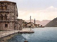 Postcard of Perast in 1900.
 -
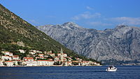 View of the town from the sea
 -
 View of the town from the west.
 -
 St Nicholas church in Perast.
 -
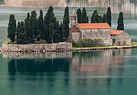 St George island.
 -
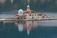 Old Perast: the artificial island Gospa od Škrpjela.
 -
 Shore of Perast.
 -
 The two islands off Perast.
.jpg)


See also
References
- ^ [1] Archived 2012-10-04 at the Wayback Machine
- ISBN 978-0-87580-130-8.
- ^ "Perast". WayMonte.com. Retrieved 1 March 2019.
- ^ ISBN 978-1-78679-198-6.
External links
| International | |
|---|---|
| National | |