Phnom Bok
| Phnom Bok | |
|---|---|
 Phnom Bok hill | |
| Highest point | |
| Elevation | 205 m (673 ft)[1] |
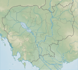
| Coordinates | 13°27′57″N 103°58′59″E / 13.46583°N 103.98306°E |
| Geography | |
| Location | Siem Reap, Cambodia |
| Climbing | |
| Easiest route | drive or hike |
| Phnom Bok Temple | |
|---|---|
Prasat Phnom Bok | |
Bakheng style of Khmer architecture | |
| Creator | King Yasovarman I (889–910 AD) |
| Completed | 9th–10th century |
| Specifications | |
| Temple(s) | Three |
| Elevation | 221 m (725 ft) |
Phnom Bok (
The site of the three hills was chosen by Yashovarman I along with the Eastern Baray (where only the base of the central shrine is surviving). In the 10th century, these shrines had high religious value during the Angkorian rule.[6] The temples called as part of an "architectural triad" brought about an element of experimentation in architectural style in the Angkorian period.[7] From the astronomical references planned for three temples, out of the four noted alignments three, namely, equinox and winter and Solar Solstices could be observed from inside the western entrance of Phnom Bok hill temple, which is also known for the triple sanctuary dedicated to the Trimurti.
Geography

Phnom Bok is the third natural hill site.[8] Its elevation is 221 metres (725 ft).[6] The hill is about 25 kilometres (16 mi) northeast of Siem Reap. It is approached from the road to Banteay Srei. An eastbound road leads to Banteay Samré for another 6 kilometres (3.7 mi) from whence the hill is approached through 635 wide steps leading to the top where the Phnom Bok temple is situated. From the top of this mountain, though the temple is seen mostly in ruins, the panoramic vistas seen all round are of the Tonlé Sap Lake, the Phnom Kulen to the north and vast plains of rice fields to the south.[4][5][9] Like Phnom Krom, Phnom Bok consists of sandstone which has a relatively high magnetic susceptibility.[10]
History
Yasovarman I, son of
Architecture
Prasat Phnom Bok, rectangular in shape and attributed to the reign of Yasovarman I, is similar in design to the Phnom Krom prasat. However, while the Phnom Krom central tower is higher than the other two flanking towers, the Phnom Bok prasat has three identical sanctum towers in a row on a single terrace.[6][15][16]
The temple is an Angkor monument. It is dedicated to the
Angkor monuments built in Angkor period architecture in Bakheng style[15] were made of sandstone and laterite but brickwork was also adopted. Laterite has been used for the walls, platforms and pavements. Greyish yellow sandstone was the main stonework used in the temples.[15]
Though the temple is in a good condition, there is over growth of two large
References
- ^ Google Earth
- ISBN 9781842125847
- ISBN 978-0-8248-0368-1.
- ^ a b c d Lonely Planet Publications (Firm) (1992). Cambodia: a travel survival kit. Lonely Planet Publications. pp. 132, 172. Retrieved 22 May 2011.
- ^ a b "Phnom Bok". Theangkor.net. Archived from the original on 25 April 2011. Retrieved 22 May 2011.
- ^ ISBN 978-90-04-11346-6. Retrieved 22 May 2011.
- ISBN 978-957-01-0880-4. Retrieved 22 May 2011.
- ISBN 978-957-01-0880-4. Retrieved 25 May 2011.
- ^ Nick Ray; Greg Bloom; Daniel Robinson. Cambodia. Lonely Planet. pp. 188–. GGKEY:ALKFLS6LY8Y. Retrieved 22 May 2011.
- ^ Engineering geology. Elsevier Pub. Co. 2000. Retrieved 27 May 2011.
- ^ Vecchia, Stefano (2007). Khmer: history and treasures of an ancient civilization. White Star. p. 80. Retrieved 27 May 2011.
- ISBN 978-81-7017-006-8. Retrieved 22 May 2011.
- ^ on each of the other two hills
- ^ ISBN 978-974-8434-93-3. Retrieved 27 May 2011.
- ^ ISBN 978-0-444-50505-7. Retrieved 22 May 2011.
- ISBN 978-90-04-10215-6. Retrieved 22 May 2011.
- ISBN 978-0-8109-0630-3. Retrieved 27 May 2011.
- ISBN 978-1-4419-7623-9. Retrieved 25 May 2011.
…site bears extensive astronomical references, among which are planned locations for observation of solar and lunar alignments, and the placement and content of bas reliefs according to the movement of the Sun through the seasons. Stencil et al. (1976) found a total of 18 alignments from various positions from inside the complex. Paris (1941) had previously noted four, three of which (equinox and winter and solar solstices) are observable from jus inside the western entrance.
- ISBN 978-1-4116-8326-6. Retrieved 27 May 2011.


