
Phnom Krom
This article relies largely or entirely on a single source. (April 2021) |
| Phnom Krom | |
|---|---|
| ភ្នំក្រោម | |
 View of Phnom Krom at dawn | |
| Highest point | |
| Elevation | 140 m (460 ft) |
| Coordinates | 13°17′09″N 103°48′44″E / 13.28573°N 103.81218°E[1] |
| Geography | |
 Phnom Krom Location of Phnom Krom in Cambodia | |
| Location | Siem Reap Province, Cambodia |
| Geology | |
| Mountain type | Sandstone |
| Climbing | |
| Easiest route | Drive, then hike |
Phnom Krom (Khmer: ភ្នំក្រោម, lit. "downstream hill") is a 140 m high hill close to Siem Reap city, Cambodia. There is a temple on the top which derived its name from the hill, Prasat Phnom Krom (Khmer: ប្រាសាទភ្នំក្រោម).
Location
Phnom Krom is about 12 kilometers southwest of Siem Reap town.
Phnom Krom hill is very rocky; local legend has it that the rocks were exposed by the monkey general
Tonle Sap
lake.
Phnom Krom railway
Phnom Krom was at the southern end of the Phnom Krom railway, a narrow-gauge French colonial railway that was most likely constructed to take stone from the now-defunct quarries on Phnom Krom to Siem Reap.
Gallery
-
 Tonle Sap lake and Phnom Krom hill
 -
 Tonle Sap lake and Chong Kneas village viewed from Phnom Krom hill
 -
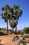 Sugar palm trees on the hill


See also
References
External links
 Media related to Phnom Krom at Wikimedia Commons
- Nick Ray, Cambodia
Capital city: Siem Reap | ||
| Districts |
|  |
| Geography | ||
| Angkor Sites | ||