Portal:Ireland/Random City
| This Wikipedia page has been superseded by historical reference. |
| Note: Article entries are now being transcluded directly on the main portal page. However, this page should be retained for historical reference. |
Random City 1
|
Baile Átha Cliath | |
|---|---|
Grand Canal Theatre, International Financial Services Centre, Four Courts, The Custom House, and Dublin Castle . | |
|
Dublin South-East | |
| • European Parliament | Dublin constituency |
| Area | |
| • City | 114.99 km2 (44.40 sq mi) |
| • Urban | 921 km2 (356 sq mi) |
| Population | |
| • City | 506,211 |
| • Density | 4,398/km2 (11,390/sq mi) |
| • Urban | 1,045,769 |
| • Metro | 1,661,185 |
| • Demonym | Dubliner Dub |
| • Ethnicity (2006 Census) | Ethnic groups |
IST) | |
| Postal districts | D1-18, 20, 22, 24, D6W |
| Area code | 01 |
| Website | www.dublincity.ie |
Random City 2
|
Corcaigh | ||
|---|---|---|
Shandon Steeple . | ||
|
Car plates C | | |
| Website | www.corkcity.ie | |
Random City 3
|
Gaillimh | ||
|---|---|---|
 The Tribes of Galway, Eyre Square | ||
|
Car plates G | | |
| Website | www.galwaycity.ie | |
Random City 4
|
Luimneach | ||
|---|---|---|
City | ||
 View looking northeast along the River Shannon | ||
|
Car plates L | | |
| Website | www.LimerickCity.ie | |
Random City 5
|
Port Láirge | ||
|---|---|---|
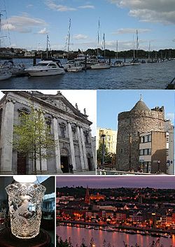
 From top, left to right: Waterford Marina, Holy Trinity Cathedral, Reginald's Tower, a piece of Waterford Crystal, Waterford City by night. | ||
|
Car plates W | | |
| Website | www.waterfordcity.ie | |
Random City 6
|
Cill Chainnigh | ||
|---|---|---|
City | ||
 | ||
|
Vehicle registration code KK | | |
| Website | www | |
Random City 7
Metropolitan area: 641,638[6] | |
|---|---|
| Irish grid reference | J338740 |
| • Dublin | 106 mi (171 km) S |
| District | |
| County | |
| Country | Northern Ireland |
| Sovereign state | United Kingdom |
| Post town | BELFAST |
| Postcode district | BT1–BT17, BT29 (part), BT36 (part), BT58 |
| Dialling code | 028 |
| Police | Northern Ireland |
| Fire | Northern Ireland |
| Ambulance | Northern Ireland |
| UK Parliament | |
| NI Assembly | |
| Website | www.belfastcity.gov.uk |
Random City 8
Random City 9
| Derry / Londonderry | |
|---|---|
 | |
Location within Northern Ireland | |
| Population | Derry 85,016 Urban 93,512 Metro 237,000 2008 est. |
| Irish grid reference | C434166 |
| District | |
| County | |
| Country | Northern Ireland |
| Sovereign state | United Kingdom |
| Post town | LONDONDERRY[1] |
| Postcode district | BT47, BT48 |
| Dialling code | 028 |
| Police | Northern Ireland |
| Fire | Northern Ireland |
| Ambulance | Northern Ireland |
| UK Parliament | |
| NI Assembly | |
| Website | www.derrycity.gov.uk |
Random City 10
Random City 11
Newry
| |
|---|---|
 Newry Town Hall and the River Clanrye | |
Location within County Down | |
| Population | 27,433 (2001 Census) |
| Irish grid reference | J085265 |
| • Belfast | 38 mi (61 km) |
| • Dublin | 67 mi (108 km) |
| District | |
| County | |
| Country | Northern Ireland |
| Sovereign state | United Kingdom |
| Post town | NEWRY AND MOURNE |
| Postcode district | BT34, BT35 |
| Dialling code | 028 |
| Police | Northern Ireland |
| Fire | Northern Ireland |
| Ambulance | Northern Ireland |
| UK Parliament | |
| NI Assembly | |
| Website | [2] |


