
Counties of Northern Ireland
| Counties of Northern Ireland | |
|---|---|
 | |
| Category | Former local government |
| Location | Northern Ireland |
| Number | Six |
| Populations | 63,585 (Fermanagh) 651,321 (Antrim) |
| Areas | 512 sq mi (1,330 km2) (Armagh) 1,261 sq mi (3,270 km2) (Tyrone) |
| Government |
|
| Subdivisions |
|
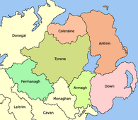
Northern Ireland is divided into six counties, namely: Antrim, Armagh, Down, Fermanagh, Londonderry[n 1] and Tyrone. Six largely rural administrative counties based on these were among the eight primary local government areas of Northern Ireland from its 1921 creation until 1973.[1] The other two local government areas were the urban county boroughs of Derry[n 1] (geographically part of the County of Londonderry) and Belfast (geographically split between the counties of Antrim and Down).
The six counties date from the
The counties
| County | County town | Created[2] | Area[3] | Population (2021)[4] | Notes |
|---|---|---|---|---|---|
| Antrim | Antrim | 1570 | 308,645 hectares (762,680 acres)[n 2] | 651,321 | Formed after Shane O'Neill's rebellion. Lost North East Liberties of Coleraine in 1613. The namesake town of Antrim was never the administrative centre of the post-1570 county. |
| Armagh | Armagh | 1571 | 132,698 hectares (327,900 acres) | 194,394 | Lost Slieve Foy to County Louth c.1630.[2] |
| Down | Downpatrick | 1570 | 248,905 hectares (615,060 acres)[n 2] | 553,261 | Formed after Shane O'Neill's rebellion. |
| Fermanagh | Enniskillen | 1588 | 185,097 hectares (457,380 acres) | 63,585 | Based on the territory of the Maguires. |
| Londonderry | Coleraine | 1613 | 211,826 hectares (523,430 acres)[n 3] | 252,231 | Merging of North-West Liberties of Londonderry (Donegal ).
|
| Tyrone | Omagh | 1591 | 326,550 hectares (806,900 acres) | 188,383 | Based on the Irish kingdom of Tír Eoghain. Lost Loughinsholin in 1613. |
Origins
The English administration in Ireland in the years following the
The area of the modern counties of Antrim and Down was the
It was not until the reign of Queen
-
 Later 15th century – Boundaries of counties and lordships (black border) and minor lordships (grey border) in Ulster.
 -
 Early 16th century – General boundaries of lordships in Ulster.
 -
 1584 – General boundaries of the counties of Ulster created by theJohn Perrott.
 -
 1613 – Ulster after the creation of County Londonderry, from the merger of County Coleraine, the North West Liberties of Londonderry (1), Loughinsholin (2), and North East Liberties of Coleraine (3).


Baronies
Each county is divided into a number of baronies, midway between a county and a parish. Baronies are now obsolete as administrative units, partially derived from the territory of an Irish chieftain. By the time the process of turning local Irish kingdoms into baronies occurred throughout the whole of Ulster by the early 17th century as part of the Plantation of Ulster, it was already being used for taxation and administrative purposes.[6]
Baronies were used for many records from the 17th to 19th centuries such as: the Civil Survey; Petty's Down Survey; the Books of Survey and Distribution; the 19th century valuation books and census returns. The Grand Jury representment system would also be based on the barony.[6]
Government and modern usage
The counties were also used as the administrative unit of local government introduced in Ireland under the 1898 Local Government Act along with
The six administrative counties and two county boroughs remain in use for some purposes, including

Lieutenancy areas
Like the rest of the United Kingdom, Northern Ireland is divided into
| NI Lieutenancy Area | Current Lord Lieutenant | Year of Appointment |
|---|---|---|
| Lieutenancy of County Londonderry | Alison Millar | 2018 |
| Lieutenancy for the County Borough of Londonderry (in the City of Derry) | Ian Crowe | 2023 |
| Lieutenacy of County Down | Gawn Rowan Hamilton | 2021 |
| County Borough of Belfast Lieutenancy | Dame Fionnuala Jay-O’Boyle | 2014 |
| Lieutenancy of County Armagh | 7th Earl of Caledon | 1989 |
| Lieutenancy of County Antrim | David McCorkell | 2019 |
| Lieutenancy of County Tyrone | Robert Lowry Scott | 2009 |
| Lieutenancy of County Fermanagh | 3rd Viscount Brookeborough | 2012 |
These boundaries of the above are contiguous with the six administrative counties and two county boroughs established by the Local Government (Ireland) Act 1898.
Former counties
Former counties which formed part of the six modern counties of Northern Ireland:
- Elizabeth I, formed the basis of modern County Londonderry.
- Carrickfergus was formerly a county of itself, it extended further than the modern borough of Carrickfergus. It was merged into County Antrimin 1899.
- Antrim, Blathewyc, Cragferus, Coulrath, del Art, Dun, Ladcathel and Twescard, the seven counties that formed the Earldom of Ulster in 1333.[9][10]
- In 1549, Ulster itself was called a county containing the baronies of Arde, Bentry, Dondalk, Dufferens, Gallagh, Grenecastle, Kroghfergous, Lacayall, Maulyn, Twscard, and Glyns.[10]
See also
- List of Northern Ireland counties by highest point
- Local government in Northern Ireland
- Counties of the United Kingdom
- Counties of Ireland
- List of Irish counties by population
- List of Irish counties by area
- Provinces of Ireland
Footnotes
- ^ a b The county and city/county borough officially named Londonderry are often called Derry; see Derry/Londonderry name dispute.
- ^ wards of Belfast respectively west and east of the River Lagan as follows:[5]
- 308,645 = 304,526 county Antrim + 4118.93 part of Belfast (all wards except Ormeau, Pottinger, Victoria)
- 248,905 = 246,624 county Down + 2281.23 part of Belfast (Ormeau, Pottinger, Victoria wards)
- 905.29 hectares of Belfast tidal area is excluded from both counties
- ^ 211,826 = 210,782 county plus 1,044 county borough.[3]
References
Citations
- ^ a b Connolly 2002 p.129
- ^ ISBN 9780199593064. Retrieved 11 July 2017.
- ^ a b c Northern Ireland General Register Office (1975). "Table 1: Area, Buildings for Habitation and Population, 1971". Census of Population 1971; Summary Tables (PDF). Belfast: HMSO. p. 1. Retrieved 28 August 2019.
- ^ "Census 2021 - Northern Ireland - County - Population". nisra.gov.uk. NISRA. Retrieved 24 October 2023.
- ^ Northern Ireland General Register Office (1975). "Table 4: Area, Population, Buildings for Habitation and Private Households — County Borough and Wards". Census of Population 1971; County Report: Belfast County Borough (PDF). Belfast: HMSO. p. 1. Retrieved 28 August 2019.
- ^ a b c d "Areas, regions, and land divisions". Public Records Office of Northern Ireland. Archived from the original on 24 August 2015.
- ^ a b c Connolly 2002 pp.589–590
- ^ "Northern Ireland (Lieutenancy) Order 1975". 1975.
- ISBN 0-85640-764-X
- ^ ISBN 085389-450-7
Sources
- Connolly, Sean J. (2002). Oxford Companion to Irish History. Oxford University Press. ISBN 978-0-19-923483-7.
- Falkiner, C. Litton (Caesar Litton) (1904). "The Counties of Ireland". Illustrations of Irish history and topography, mainly of the seventeenth century. London: Longmans, Green. pp. 103–142: 127–128. Retrieved 28 August 2019.