
Sławków
Sławków | |
|---|---|
 Town hall | |
 Flag  Coat of arms | |
 Sławków | |
| Coordinates: 50°19′N 19°23′E / 50.317°N 19.383°E | |
| Country | |
| Voivodeship | |
| County | Będzin |
| Gmina | Sławków (urban gmina) |
| Area | |
| • City | 36.6 km2 (14.1 sq mi) |
| Population (2019-06-30[1]) | |
| • City | 7,017 |
| • Density | 190/km2 (500/sq mi) |
| • Urban | 2,746,000 |
| • Metro | 5,294,000 |
| Postal code | 41-260 |
| Website | http://www.slawkow.pl |
Sławków
Location
Sławków is located in western
History
Archaeological sites from the Paleolithic and Neolithic ages have been discovered giving evidence to early human settlement in the area. The first written record of the town's name comes from 1220. However, the exact date of its incorporation remains unknown. Indirect written sources indicate that it most probably took place between 1279 and 1286. This assumption is supported by two documents from the 13th century: a charter issued in 1279 by Prince Bolesław V the Chaste, in which the locality is still called a village (villa episcopalis) and an agreement dated 1286 between the Bishop of Kraków Paweł z Przemankowa and Prince Leszek II the Black, in which Sławków is already called a town (civitas). In the 1280s, Bishop Paweł z Przemankowa built here a defensive castle, located near western border of Lesser Poland.
Due to rich deposits of lead and silver, and location on a merchant route from Kraków to Wrocław, Sławków quickly developed, and in the 13th century it was one of the most important urban centers of Lesser Poland. In the 14th century its importance diminished, and later on, the town was destroyed several times in numerous wars (1433, 1434, 1455), as well as in a fire (1498). Furthermore, the deposits of silver and lead dried out. Until the Partitions of Poland, Sławków remained administrative center of properties of the Bishop of Kraków.
In 1795 Sławków briefly belonged to
Points of interest
- Medieval center of the town, with a market square, and a town hall from 1905
- 18th-century inn (austeria),
- St. Nicholas Church,
- complex of church parish (18th century),
- hospital for miners (1758),
- ruins of the castle of Bishops of Kraków (13th century, destroyed in 1455 and never rebuilt),
- Lamus – manor house of Bishops of Kraków (18th century)
- St. Jacob Church (1827)
- St. Rozalia wayside shrine (1536)
Demographics

-
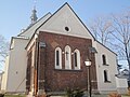 Sławków church (13th century)
 -
 old inn from 1781
 -
 ruins of the Sławków castle (13th century)
 -
 market square ca. 1919
 -
 market square southern frontage
 -
 one of the streets
 -
 railway station
 -
 post office
 -
 primary school


Broad gauge railway
Twin towns – sister cities
 Horní Slavkov, Czech Republic
 Malý Slavkov, Slovakia
 Messeix, France
- Slavkov u Brna, Czech Republic
References
- ^ "Population. Size and structure and vital statistics in Poland by territorial division in 2019. As of 30th June". stat.gov.pl. Statistics Poland. 2019-10-15. Retrieved 2020-02-14.
- ^ "Miasta partnerskie". slawkow.pl (in Polish). Sławków. Retrieved 2020-03-11.
External links
- Jewish Community in Sławków on Virtual Shtetl
- Official Website Official city website
| Urban gminas |  | |
|---|---|---|
| Urban-rural gmina | ||
| Rural gminas | ||
| International | |
|---|---|
| National | |
| Geographic | |