
Schwalbach am Taunus
Schwalbach am Taunus | |
|---|---|
 Coat of arms | |
Location of Schwalbach am Taunus within Main-Taunus-Kreis district 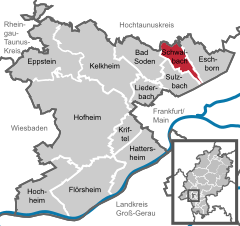 | |
 Schwalbach am Taunus  Schwalbach am Taunus | |
| Coordinates: 50°09′N 08°32′E / 50.150°N 8.533°E | |
| Country | Germany |
| State | Hesse |
| Admin. region | Darmstadt |
| District | Main-Taunus-Kreis |
| Government | |
| • Mayor (2020–26) | Alexander Immisch[1] (SPD) |
| Area | |
| • Total | 6.47 km2 (2.50 sq mi) |
| Highest elevation | 204 m (669 ft) |
| Lowest elevation | 117 m (384 ft) |
| Population (2022-12-31)[2] | |
| • Total | 15,519 |
| • Density | 2,400/km2 (6,200/sq mi) |
| Time zone | UTC+01:00 (CET) |
| • Summer (DST) | UTC+02:00 (CEST) |
| Postal codes | 65824 |
| Dialling codes | 06196 |
| Vehicle registration | MTK |
| Website | www.schwalbach.de |
Schwalbach am Taunus, a town in the
Geography
Location
The town is located between
The original settlement, now known as Alt-Schwalbach, was built at the confluence of the Sauerbornbach and the Waldbach. Below the confluence, the stream is known as the Schwalbach.[4] ("Bach" = "brook" or "stream").
Before given over to human habitation, much of the area was heavily wooded - the northern tip of the municipality is still given over to woodland.
History

Although the written history of Schwalbach only goes back to 781 AD, archaeological discoveries made in 1961 to 1963 during the building of the town's centre indicate the existence of a Neolithic settlement (about 5000 BC).[5] In
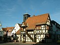
The Rennstraße,[6] that linked Frankfurt to Königstein im Taunus as part of the ancient route between Frankfurt and Cologne dating from Merovignian times passed through Schwalbach; the modern-day Mutter Kraus restaurant was a seventeenth century coaching[7] in on the route.
The first time Schwalbach was mentioned documentarily was in 781 AD, when a knight named Starcfrit and his mother Mechthilt made a gift to the cloister Lorsch at the Bergstrasse. This gift was 70 joch about 25 hectares (62 acres) arable farm land, two farms and grassland in "villa Sualebach". For centuries Schwalbach was a small farming village with a population of 200, at most 300 inhabitants. It was always a dependency of one or another outside lord and in the year 1635 came into the lordship of Königstein, which in turn was owned by the Electorate of Mainz. In the castle of Schwalbach, the committed knights of the gentry execute their sovereignty and also jurisdiction as steward or sheriffs.
After the
Not until the Franco-Prussian War from 1870/71, first changes were to bespoken in Schwalbach. Young men work as craftsmen in the industrial enterprises of the near suburbs of Frankfurt (Rödelheim, Höchst or Bockenheim). A slight increase of the artisan class, as well as a steady rise of the popularity of Schwalbach as an excursion destination for the citizens of Frankfurt is registered. From 1,500 in 1925 to 3,300 in 1956 the population figure increases steadily.
The
Between 1960 and 1964 the limes development, located uphill from the confluence of the two stream feeding the Schwalbach provided homes for 11,000 people, a major factor in the town's population growing to 15,000 by 1970.[8]
The number of homes destroyed in the Second World War and the growing number of young families with children let start the idea to build a residential town in the countryside, next to the inner city, in Schwalbach. With the limes residential city an award-winning urban construction model has been implemented, which is served by line S 3 of the Rhine-Main S-Bahn and has churches, kindergartens, schools, sports fields, a public swimming pool and a lot of public green space. The population of Schwalbach is growing by leaps and bounds in those years. In 1970 about 14,000 inhabitants were counted. On May 9, 1970 Schwalbach preserved the municipal law. From the small farming village, which was often called “Little Schwalbach”, a modern city with many benefits came up.
Climate
| Schwalbach am Taunus[9] | ||||||||||||||||||||||||||||||||||||||||||||||||||||||||||||
|---|---|---|---|---|---|---|---|---|---|---|---|---|---|---|---|---|---|---|---|---|---|---|---|---|---|---|---|---|---|---|---|---|---|---|---|---|---|---|---|---|---|---|---|---|---|---|---|---|---|---|---|---|---|---|---|---|---|---|---|---|
| Climate chart (explanation) | ||||||||||||||||||||||||||||||||||||||||||||||||||||||||||||
| ||||||||||||||||||||||||||||||||||||||||||||||||||||||||||||
| ||||||||||||||||||||||||||||||||||||||||||||||||||||||||||||
Points of interest
International relations
Schwalbach am Taunus is
Visual impressions
-
 Apartment houses (part of the Limesstadt)
 -
 S-Bahn station "Schwalbach (Limes)" at Limes Railway
 -
 Seventeenth century coaching inn, the Mutter Kraus
 -
 1894 built chapel
 -
 Former town hall in the marketplace


References
- Müller-Pilgram, Heinz; Ravens, Jürgen K L, eds. (1 May 2006). Schwalbach erleben (in German). Verschönerungs-Verein Schwalbach-am-Taunus e.V.
- "Homepage Schwalbach am Taunus" (in German). Retrieved 6 May 2012.
- Hessisches Statistisches Landesamt. 5 September 2022.
- Hessisches Statistisches Landesamt. June 2023.
- ^ ISBN 978-3-8297-4006-7.
- ^ ISBN 978-3-8297-4006-7.
- ^ Farnung, Dieter: Schwalbach erleben - Die Historie von Schwalbach (The History of Schwalbach)
- ^ Frank Mechelhoff (2005). "Altstraßen im Taunus und angrenzenden Gebieten Hessens, von der Römerzeit und Karl dem Großen, bis in die Neuzeit" [Ancient roads in the Taunus and neighbouring areas in Hessen from Roman and Carolignian times to the modern day.]. Taunusreiter (in German). Retrieved 18 March 2012.
- ^ Plaque on the wall of the building - viewed on 16 April 2012
- ISBN 3-87666-021-1.
- ^ "Wetter in der Region Frankfurt/Main" [Weather in the Frankfurt am Main region]. Retrieved 15 April 2012.
- ^ "Warm welcome for German twin town visitors". Darlington & Stockton Times. 10 July 2009. Retrieved 10 April 2020.
External links
- Official website
 (in German)
Towns and municipalities in Main-Taunus-Kreis district | ||
|---|---|---|
 | ||
| International | |
|---|---|
| National | |
| Geographic | |