
Skuleskogen National Park
| Skuleskogen National Park | |
|---|---|
| Skuleskogens nationalpark | |
 | |
| Location | Västernorrland County, Sweden |
| Coordinates | 63°07′N 18°30′E / 63.117°N 18.500°E |
| Area | 30.62 km2 (11.82 sq mi)[1] |
| Established | 1984, extended 2009[1] |
| Governing body | Naturvårdsverket |
Skuleskogen National Park (Swedish: Skuleskogens nationalpark, literally The Skule Forest National Park) is a Swedish national park in Västernorrland County, on the coast of the Baltic Sea, in northern Sweden. It covers 30.62 km2 (11.82 sq mi), constituting the eastern part of the Forest of Skule.
The park is characterized by a very rough topology with many rocky peaks, of which the highest is Slåttdalsberget, 280 m (920 ft) in altitude, rising directly from the sea. The topography is also marked by the presence of deep crevasses and caves. This particular topology can be found throughout the entire High Coast (Swedish: Höga kusten), a region of Sweden so named because it constitutes the highest section of the coast of the Baltic Sea. This region is in our day principally known as a favoured site for the observation of the phenomenon of post-glacial rebound. Most of the region was under the sea less than 10,000 years ago, after the ice sheet that blanketed it melted. But thanks to the melting of this mass of ice that had been pressing down upon it, the ground is rising year by year, at a current speed of 8 mm (0.31 in) per year.
Humans have left their mark upon the park, although they probably never established themselves there in great numbers. Numerous
Today, despite its distance from areas of dense human population, the park is a relatively important site of tourism with 20,000 visitors per year. The principal attraction of the park is the 40 m (130 ft) deep crevasse of Slåttdalskrevan, which is easily accessible by numerous hiking trails, including the Höga Kustenleden, which goes along the whole of the High Coast.
Toponymy
The national park takes its name from the forest of Skule, of which it constitutes the eastern part. The name Skuleskogen in Swedish means "the forest of Skule", the word Skule being common in the place names nearby, with for example Skuleberget ("mountain of Skule"), Skulesjön ("lake of Skule") or even the villages Skule and Skulnäs.[2] However, there is a debate as to which toponym came first and was then transmitted to the others, as well as the meaning of this toponym.[2]
A first hypothesis is that the name would have issued from the mountain Skuleberget, this being a point particularly notable in the landscape and one which would thus have been rapidly named.[2] This name already appears in 1539 in the form Scyla mons and would derive from skjul meaning "hiding place", the famous cave in the mountain having been in the past a refuge for brigands.[3] Another hypothesis is that the name would have come from the village of Skule; Skuleskogen thus being "the forest on the way to Skule" or "the forest which belongs to Skule", Skule being the village allowed to pasture animals in the forest.[2] This last hypothesis does not imply that the mountain did not have a name before the village of Skule came into being; the original name would have been a name which one ought not to pronounce, as is true of many places in the country, another name not forbidden then coming into common usage and replacing the old one.[2]
Geography
Location and borders
Skuleskogen National Park is in the municipalities of Örnsköldsvik and Kramfors, both of Västernorrland County, both in the historical Swedish province of Ångermanland.[4] It is 27 kilometres (17 mi) south of the city of Örnsköldsvik and 40 kilometres (25 mi) north of the city of Kramfors, the respective capitals of the municipalities mentioned above.[S 1] It covers a surface area of 3,062 hectares (7,570 acres) of which 282 hectares (700 acres) are maritime,[S 2] the park stretching, in fact, along the coast of the Baltic Sea.
Topography

The park is included in the region called the High Coast, a zone of very rough relief, forming a joint valley landscape (Swedish: sprickdalslandskap): a landscape gouged by many small valleys formed by the erosion of fissures and faults in the bedrock.[H 1] The High Coast is generally defined as the portion of the eastern coast of Sweden between the cities of Härnösand and Örnsköldsvik.[H 2] The name of this region comes from the fact that it is the highest section of the coast of the Baltic Sea, numerous summits elevating themselves from the sea to attain altitudes of 200 to 250 metres (820 ft).[H 2] This rugged terrain stretches even under the surface of the sea; so, it is in this region that one finds the deepest point of the Bothnian Sea, Ulvödjupet, with a depth of 293 metres (961 ft).[H 3] The park itself covers the eastern part of the forest of Skule, characterized by a terrain forming a sort of wall separating the north and the south.[H 4]

The topography of the park is characterized by these small valleys (sprickdal), some even taking the appearance of vertitable crevasses, the most impressive being Slåttdalskrevan (40 metres (130 ft) deep, 200 metres (660 ft) long, 8 metres (26 ft) wide), but also significant being Trollporten (the "Trolls' Door"), a small crevasse celebrated for the rock that rests across the top.[H 1] Another characteristic element is the presence of many caves, although the most famous, Skulegrottan, in the mountain Skuleberget, is not inside the park.[H 5] The park's highest peak is Slåttdalsberget, at 280 metres (920 ft) of altitude.[5]
Climate
The national park is bathed in a subarctic climate (Dfc according to the Köppen classification). The maritime influence explains why its early summers are colder than they are farther inland, but its autumns are in contrast more mild.[S 3] The topography causes important local variations.[S 3] The climate is humid, with about 700 millimetres (28 in) of precipitation per year, of which more than a third in the form of snow, forming a snow cover lasting on average 175 days.[S 3] Spring is the driest season, and in certain years this relative dryness has important consequences for the environment, especially because the thinness of the soil retains moisture poorly.[S 3] In the regions acid rain most powerfully affected, surveys indicated that the situation is getting better, the pH of the precipitation gently increasing.[S 3]
The nearest climate station to Skuleskogen National Park is in the village of Västmarkum, approximately 10 kilometers west. The station’s more inland and elevated (143 meters) positioning possibly renders the national park much milder, especially during late summer and early fall.
According to the Köppen climate classification, Skuleskogen National Park has a borderline subarctic climate (Dfc) with a notable dry-spring/early summer precipitation pattern. Extremes have ranged from 30.8°C set during June 2020, to an all-time low of -26.4°C from February 2018. The driest year was 2018 with 647 millimeters of precipitation whereas the wettest was 2020 when 1,061 millimeters of precipitation fell. The annual precipitation of almost 1000mm is by Swedish standards, especially east coast standards, very high. The high precipitation anomaly is largely due to the orographic lift effect owing to the adjacent hilly terrain of the High Coast. The precipitation is anticipated to further increase because of climate change. It is widely known that the region’s snow depth can vary depending on elevation and maritime influence from the Bothnian Sea. It is thus a high possibility the given snow depth data is skewed since it is measured 30 kilometers south of the Skuleskogen National Park, meaning that the park probably receives more snowfall.
| Climate data for Västmarkum A 2018-2023 averages and extremes; snow depth in Nora Östanö D 2018-2023. | |||||||||||||
|---|---|---|---|---|---|---|---|---|---|---|---|---|---|
| Month | Jan | Feb | Mar | Apr | May | Jun | Jul | Aug | Sep | Oct | Nov | Dec | Year |
| Record high °C (°F) | 9.2 (48.6) |
8.5 (47.3) |
14.4 (57.9) |
21.2 (70.2) |
25.3 (77.5) |
30.8 (87.4) |
30.1 (86.2) |
28.6 (83.5) |
24.0 (75.2) |
18.7 (65.7) |
11.7 (53.1) |
6.6 (43.9) |
30.8 (87.4) |
| Mean maximum °C (°F) | 5.5 (41.9) |
6 (43) |
10.3 (50.5) |
15.3 (59.5) |
22.4 (72.3) |
26.2 (79.2) |
26.4 (79.5) |
24.6 (76.3) |
19.3 (66.7) |
13.5 (56.3) |
7.7 (45.9) |
4.5 (40.1) |
26.4 (79.5) |
| Mean daily maximum °C (°F) | −1.7 (28.9) |
−0.2 (31.6) |
2.8 (37.0) |
7.9 (46.2) |
13.6 (56.5) |
19.8 (67.6) |
21.0 (69.8) |
19.3 (66.7) |
14.5 (58.1) |
6.4 (43.5) |
1.5 (34.7) |
−1.3 (29.7) |
8.6 (47.5) |
| Daily mean °C (°F) | −5.8 (21.6) |
−5.6 (21.9) |
−3.4 (25.9) |
2.2 (36.0) |
7.3 (45.1) |
13.3 (55.9) |
15.0 (59.0) |
13.8 (56.8) |
9.4 (48.9) |
3.0 (37.4) |
−1.4 (29.5) |
−4.8 (23.4) |
3.6 (38.4) |
| Mean daily minimum °C (°F) | −9.8 (14.4) |
−11.0 (12.2) |
−9.5 (14.9) |
−3.6 (25.5) |
0.9 (33.6) |
6.8 (44.2) |
9.0 (48.2) |
8.3 (46.9) |
4.2 (39.6) |
−0.4 (31.3) |
−4.3 (24.3) |
−8.3 (17.1) |
−1.5 (29.4) |
| Mean minimum °C (°F) | −20.9 (−5.6) |
−22.3 (−8.1) |
−20.7 (−5.3) |
−11.6 (11.1) |
−4.7 (23.5) |
0.7 (33.3) |
2.6 (36.7) |
1.2 (34.2) |
−2.1 (28.2) |
−8.0 (17.6) |
−14.4 (6.1) |
−19.7 (−3.5) |
−22.3 (−8.1) |
| Record low °C (°F) | −25.3 (−13.5) |
−26.4 (−15.5) |
−24.6 (−12.3) |
−15.7 (3.7) |
−6.8 (19.8) |
−0.4 (31.3) |
−0.1 (31.8) |
−0.4 (31.3) |
−4.1 (24.6) |
−10.5 (13.1) |
−19.6 (−3.3) |
−25.6 (−14.1) |
−26.4 (−15.5) |
| Average precipitation mm (inches) | 101.8 (4.01) |
58.0 (2.28) |
53.2 (2.09) |
38.3 (1.51) |
47.5 (1.87) |
41.5 (1.63) |
107.3 (4.22) |
114.6 (4.51) |
101.2 (3.98) |
108.0 (4.25) |
93.7 (3.69) |
111.3 (4.38) |
976.4 (38.42) |
| Average extreme snow depth cm (inches) | 47.4 (18.7) |
51.2 (20.2) |
46.1 (18.1) |
23.7 (9.3) |
0.8 (0.3) |
0 (0) |
0 (0) |
0 (0) |
0 (0) |
0 (0) |
4.9 (1.9) |
36.9 (14.5) |
51.2 (20.2) |
| Average precipitation days | 19.2 | 14.0 | 12.7 | 10.2 | 11.8 | 10.5 | 14.3 | 14.7 | 16.8 | 18.2 | 16.3 | 20.2 | 178.9 |
| Source 1: SMHI Open Data(Temperature & Precipitation)[6] | |||||||||||||
| Source 2: SMHI Open Data(Snow Depth)[7] | |||||||||||||
Hydrology

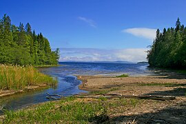
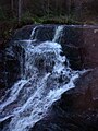
Many streams run through the park, feeding many lakes. The principal lakes are Tärnättvattnen (7.9 hectares (20 acres)) and Stocksjön (6.1 hectares (15 acres)) belonging to the watershed of the streams Skravelbäcken and Långtjärnen (3.9 hectares (9.6 acres)), belonging to the watershed of the stream Nylandsbäcken.[S 4] A non-negligible section of the park (125 hectares (310 acres)) is made up of fens.[S 2]
Geology
Bedrock

The principal rock of the park is the granite of Nordingrå, the park belonging to the Nordingrå massif.[S 3] It consists of a rapakivi granite, formed about 1500 million years ago.[S 3] It has a characteristic bright red color and erodes easily.[S 3] To the north-east of the park, one can also find diabase, which was formed 1200 million years ago in the faults of the Nordingrå massif.[S 5] Since granite forms a substrate very poor in nutrients, the diabase constitutes by contrast a very fertile terrain, which permits a richer vegetation.[S 5]
The national park is traversed by several faults, like the rest of the High Coast.[S 5] These faults were filled by deposits which marine erosion sometimes later removed.[S 5] One of the most impressive examples of this phenomenon is Slåttdalsskrevan, east of the park : a crevasse of 40 metres (130 ft) depth and 200 metres (660 ft) width, which is one of the park's most visited sites.[S 5] This crevasse was a fault filled by a vein of diabase, which was however eroded later, in part by the sea.[8]
The High Coast

At
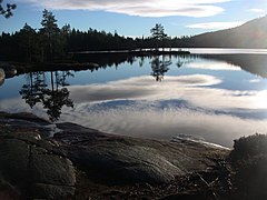
The post-glacial rebound continues even today: the island of Tärnättholmarna, inside the park, is becoming bit by bit a peninsula,[S 5] and the bay of Salsviken is now a lake isolated from the sea by a small strip of sand.[8]
-
 Sandy area separating the bay of Salsviken from the sea.
 -
 The islands of Tärnättholmarna, in the background, are now in fact peninsulas.
 -
 Rubble polished by waves before the post-glacial rebound lifted it out of the water.


Environment
Fauna

The park is home to many species of mammal characteristic to northern Sweden, in particular the
With respect to birds, many species are also on the endangered list in Sweden, such as the
The rivers and lakes of the park are relatively poor. They are home mainly to European perch (Perca fluviatilis) and brown trout (Salmo trutta), but the stream Skravelbäcken is also home to brook trout (Salvelinus fontinalis).[S 7] The sea has Atlantic herring (Clupea harengus), but also northern pike (Esox lucius), trout, and perch, the Baltic Sea having low salinity.[S 7]
Little is known of the park's
Flora

Skuleskogen is located on the northern border of the range of several plant species. Thus several deciduous tree species are present in the park, such as the
However, deciduous forest only covers 42 hectares (100 acres), barely more than 1.4% of the surface area of the park.

In the coniferous forests, one can find several shrubs, of which the most common are
A large part of the park (36%) consists of naked rock, and is thus a poor substrate for vegetation.
Many mosses and lichens of the park are considered endangered in Sweden, in particular Dolichousnea longissima, which is now the park's symbol.[14]
History
Protohistory

Because of the topography and the nature of the terrain, the area did not lend itself to human settlement and no trace of permanent habitation had been found in the park.
No traces dating from the Iron Age have been discovered.[S 10]
Exploitation of the park

The forest of Skule has always been a topographic barrier.[H 2] For example, it would have perhaps have been the northern frontier of the kingdom of Svealand before the year 1000,[H 2] and thus the border between adjacent municipalities and parishes.[H 8] The villages it separated had very limited contact with each other[H 8] and, because of the poor agricultural potential of the forest, there was never a permanent settlement in the forest.[H 9] The forest was, however, traversed by a trail, which later took the name of Kustlandsvägen and which corresponded roughly to the path of today's European route E4.[H 10] For a long time, this path constituted the only road to the north of the country.[H 10] The zone was thus the property of the Swedish crown, which could decide who could use the forest as pasture or engage in logging there.[H 9] In the 17th century, unlike many of the northern Swedish forests belonging to the crown, Skuleskogen did not see any colonization by the Forest Finns (Skogsfinnar), and thus did not undergo slash-and-burn cultivation techniques.[H 9] The forest was instead used as a summer pasture (transhumance), and the hay of the marshes was used as well, although in a very localized fashion.[S 12] As a result, in today's national park there were four summer pasture cottages, three having existed up until the turn of the 20th century, while the last (Näskebodarna) remained active up until the end of World War II.[H 9] This last is now used, maintained in its old state, for tourism.[H 9] The forest would seem to be more open in those days than now.[S 12]
At the same time, it would seem that the
After the Great Northern War at the beginning of the 18th century, Sweden encouraged the foundation of villages on its territories by tax exemptions.[H 9] As a result, a few isolated villages were established in the forest of Skuleskogen, but none in today's park.[H 9] Until the middle of the 18th century, logging was limited to the area directly around the villages and thus only minimally affected the forest of the park.[H 11] But that soon changed, the state taking an active part in the exploitation of the forest.[H 11] Logging became the principal activity in the area of the park.[S 11] In a few years, a dozen mills, including a steam mill, were constructed in immediate proximity to today's park.[S 11] The sawmills driven by water wheels only had weak capacities in general and only functioned during certain periods of the year.[S 11] The number of steam mills grew thereafter.[S 11] At first, only the trees with trunks over a fixed length in diameter were able to be cut, but bit by bit, these rules changed, and in the end all the trees were able to be felled.[H 12] Logging slowed down markedly at the turn of the century, allowing the forest to regenerate.[S 11] About 15% of the forest was affected by a new period of exploitation before the protection of the area.[H 12] The forest's oldest trees therefore date from the start of the 20th century.[H 12]
Protection

Upon a great inventory of the environment of the county in the middle of the 1960s, Skuleskogen was noticed for its great natural value.
The creation of the national park took place in May 1984.
Management and administration
Like most of the national parks of Sweden, management and administration are divided between the Swedish environmental protection agency (
The park is divided into three zones, each having a purpose, in order to reconcile the protection of the park and the welcoming of tourists. The majority (65%) of the park is classified as zone I, that is, as a low-activity zone: this space is the heart of the park and has scarce tourism infrastructure, so that the environment remains intact.[S 16] The eastern third of the park is classified as zone II, the high-activity zone.[S 17] In this zone you can find most of the trails and cabins, as well as the most popular sites.[S 17] Finally, a very small part (150 hectares (370 acres)) is classified zone III, being that zone in immediate proximity to the entrances.[S 17] This zone can accommodate a great number of visitors before channeling them towards the main trails.[S 17]
Tourism

The park is very accessible and its location at the heart of the High Coast, a UNESCO World Heritage site, earns it 20,000 visitors a year,[S 18] which is relatively large, given its location in Norrland.
The park has three entrances, one each to the north, south, and west, the north entrance being the main one.[S 18] The three entrances are near European route E4, which is the main road in northern Sweden, and which traverses the country from end to end. Near these entrances one can find parking and information panels about the park.[S 19] It is possible to spend the night in the park in one of five shelters (Norrsvedjebodarna, Tärnettvattnen, Tärnettholmarna, Tärnettsundet, and Näskebodarna). These were private homes before the foundation of the park.[S 20] It is also possible to go camping in the dedicated campgrounds.[19]
Many hiking trails run through the park, especially through its easternmost third. In particular, the grand hiking trail Höga Kustenleden (the trail through the High Coast) traverses the park from north to south over 8.7 kilometres (5.4 mi).[S 20] This trail can moreover constitute a means of accessing the park from the villages of Docksta and Bjästa, which are themselves accessible by public transport.[H 15] Besides by hiking, it is also possible to discover the park by skiing in winter; its topology even permits alpine skiing.[H 16] It is also possible to go kayaking along the coast[S 21] and to go swimming, in particular at the sandy beaches of Tärnättholmarna or in the lagoon of Salsviken to the north, where the water can attain warmer temperatures.[H 17] Biking is allowed on the trail along the coast.[S 21]
The most visited site in the park is probably the crevasse of Slåttdalsskrevan, but also popular are the view from over the archipelago from the nearby summit of Slåttdalsberget, as well as the Bronze Age funerary cairns.[20]
-
 The naturum Höga kusten houses permanent exhibits on the High Coast.
 -
 The cabin of Tärnättholmarna.
 -
 Tärnetvattnen


Skuleskogen in popular culture
Skuleskogen is the setting of the novel The brigands of the forest of Skule (Rövarna i Skuleskogen) by Kerstin Ekman. The book tells the story of Skord, a troll of human appearance from the forest of Skule. His curiosity about humans leads him into numerous adventures across the ages (he is immortal).[21] The title references a local legend, that robbers arrived in the area in the 7th century, but were rejected by the villagers of the area. They had to take refuge in the cave Skulegrottan not far from the park.[22] These brigands committed numerous misdeeds, attacking those who crossed the forest.[22] They ended up getting done in by a young peasant who succeeded in joining their group by saying that the villagers had rejected him too.[22]
-
 Tärnetvattnet
 -
 Skravelbäcken
 -
 View over the Gulf of Bottnia from Slottdalsberget
 -
 Slottdalsskrevan


Notes and references
- This article was initially translated from the French Wikipedia.
- ISBN 978-91-620-8410-3.
- Swedish University of Agricultural Sciences (2003). Naturvårdsverket (ed.). "Dokumentation av de svenska nationalparkerna" (PDF) (in Swedish). ISBN 91-620-5329-9.
- Johansson, Sven K.-J.; Simonsson, Per; Wallin, Bertil Charlie (1984). CeWe-förl. (ed.). "Skuleskogen, nationalparken i Höga kusten" (in Swedish). ISBN 91-7542-116-X.
- Others
- ^ a b "Skuleskogen National Park". Naturvårdsverket. Retrieved 2019-07-06.
- ^ ISBN 91-86138-03-0.
- ^ "Skuleberget". Nationalencyklopedin (in Swedish). Retrieved 31 January 2012.
- ^ "Skuleskogen National Park". Naturvårdsverket. Archived from the original on 26 March 2011. Retrieved 28 July 2011.
- ^ cf. the map of the park Archived 2012-05-03 at the Wayback Machine
- ^ "SMHI Monthly Data 2018–2023 Temperature" (in Swedish). SMHI. Retrieved 11 Jan 2024.
- ^ "SMHI Monthly Data 2018–2023 Snow Depth" (in Swedish). SMHI. Retrieved 11 Jan 2024.
- ^ a b "Geologiskt världsarv". Skuleskogen (in Swedish). Retrieved 18 June 2012.
- ^ Nordlund, Christer (2005), How the Coast Became High: An Historical Introduction to the High Coast (Höga Kusten) World Heritage Site in Sweden, Environment and History
- ^ "Haute Côte / Archipel de Kvarken". Convention du patrimoine mondial UNESCO (in French). Retrieved 2 February 2012.
- ^ a b "Skuleskogen där berg möter hav" (PDF). Länsstyrelsen i Västernorrland (in Swedish). Retrieved 2 February 2012.
- ^ "Sydväxtberg". Nationalencyklopedin (in Swedish). Retrieved 1 February 2012.
- ISBN 91-620-5329-9.
- ^ "Gränsland och ytterligheter". Skuleskogens nationalpark (in Swedish). Retrieved 29 July 2011.
- ^ "Entréprojektet 2008-2010". Skuleskogen (in Swedish). Retrieved 18 June 2012.
- ^ "Förordning om ändring i nationalparksförordningen (1987:938)" (PDF). Lagbocken (in Swedish). Retrieved 25 January 2012.[permanent dead link]
- ^ "Décision - 30COM 8B.27 - Extensions de biens inscrits sur la Liste du patrimoine mondial (Archipel de Kvarken / Haute Côte)". Convention du patrimoine mondial (in French). Retrieved 12 February 2012.
- ^ a b c "Nationalparksförordning (1987:938)". Notisum (in Swedish). Retrieved 14 May 2011.
- ^ "Övernattning". Skuleskogens nationalpark (in Swedish). Retrieved 30 July 2011.
- ^ "Turförslag". Skuleskogens nationalpark. Retrieved 30 July 2011.
- ^ "Les brigands de la foret de Skule" (in French). Actes Sud. Retrieved 23 January 2012.
- ^ a b c Axelsson, Anna-Lena (1999). "Historien bakom Skuleskogen" (PDF) (in Swedish).
External links
- Skuleskogens Nationalpark - Swedish Visitor Guide to Skuleskogen and Skuleberget
- Skule National Park - English Visitor Guide
- Sweden's National Parks: Skuleskogen National Park from the Swedish Environmental Protection Agency