
Souda
Souda
Σούδα | |
|---|---|
UTC+3 (EEST) | |
| Vehicle registration | ΧΝ |
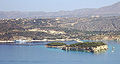
Souda (Greek: Σούδα) is a town and former municipality in the Chania regional unit, Crete, Greece. Since the 2011 local government reform it is part of the municipality Chania, of which it is a municipal unit.[2] The municipal unit has an area of 22.007 km2 (8.497 sq mi).[3] It is an important ferry and naval port at the head of Souda Bay.
Souda is 6.5 kilometres (4.0 miles) to the east of central
Now Souda is the arrival point for ferries from
The
Souda municipal unit
Souda was the main town in the former municipality of the same name, with the town hall found in Souda itself. The municipal unit extends from Chania's hinterland (Souda, Nerokouros and Tsikalaria) along the coast, taking in the villages of Kalami and Megala Chorafia. Around 8,400 people live in the municipal unit, the majority in Souda itself. Due to the area's beautiful views across the sea and up to the White Mountains and its proximity to Chania, there is a great deal of pressure to build new houses and apartments. However, there has been some protection afforded by the restrictions of having a military base in the area.
Sinking of HMS York during WWII
During World War II, the Royal Navy heavy cruiser HMS York was disabled at Souda Bay by two Italian explosive motorboats (Italian: barchini esplosivi) of the Italian Decima Flottiglia MAS, launched by destroyers Crispi and Sella on 26 March 1941. Six motorboats entered the bay, led by Lieutenant Luigi Faggioni, and attacked three targets in pairs; the first was York, second the tanker Pericles and last another ship at anchor. Three of the attacking craft had various problems, either mechanical or human, due to the extreme temperature conditions, but the other three successfully attacked their targets. Two motorboats, packed with 330-kilogramme (667 lb) charges in the bows, struck York amidships, flooding both boiler rooms and one engine room. Two seamen were killed.
Gallery
-
-
 View of the islet of Leon, from the Venetian fortifications on the islet of Souda, within Souda Bay.
 -
 View from the walls of the Souda fortress.


References
- ^ "Αποτελέσματα Απογραφής Πληθυσμού - Κατοικιών 2021, Μόνιμος Πληθυσμός κατά οικισμό" [Results of the 2021 Population - Housing Census, Permanent population by settlement] (in Greek). Hellenic Statistical Authority. 29 March 2024.
- ^ "ΦΕΚ B 1292/2010, Kallikratis reform municipalities" (in Greek). Government Gazette.
- ^ "Population & housing census 2001 (incl. area and average elevation)" (PDF) (in Greek). National Statistical Service of Greece.