
Spicket River
| Spicket River | |
|---|---|
Derry, NH | |
| • coordinates | 42°51′27″N 71°12′48″W / 42.85750°N 71.21333°W / 42.85750; -71.21333 |
| • elevation | 205 ft (62 m) |
Methuen, MA | |
• coordinates | 42°42′22″N 71°8′47″W / 42.70611°N 71.14639°W / 42.70611; -71.14639 |
• elevation | 31 ft (9.4 m) |
| Length | 17.7 mi (28.5 km) |
| Basin features | |
| Tributaries | |
| • left | Providence Hill Brook, Captain Pond Brook, World End Brook |
| • right | Widow Harris Brook, Policy Brook |
The Spicket River is a 17.7-mile-long (28.5 km)[1] river located in New Hampshire and Massachusetts in the United States. It is a left tributary of the Merrimack River, part of the Gulf of Maine watershed. It is sometimes spelled "Spickett".[2]
The Spicket River begins at the outlet of Island Pond in Derry, New Hampshire, and flows south into Salem, New Hampshire, passing through the Arlington Mill Reservoir. The river continues through Salem, encountering copious suburban development, and enters the city of Methuen, Massachusetts, where it drops nearly 100 feet (30 m) in elevation over a series of dams on its way to the Merrimack River in Lawrence.
-
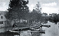 Boat house circa 1900 in Methuen, Massachusetts
 -
 Broadway Bridge, Methuen
 -
 Spicket River Dam in Methuen
 -
 Sands Bridge on Hampshire Rd, Methuen


See also
References
| Atlantic Ocean |
| ||||||||
|---|---|---|---|---|---|---|---|---|---|
| Gulf of Maine |
| ||||||||
| Long Island Sound |
| ||||||||
| Narragansett Bay |
| ||||||||
Upper New York Bay |
| ||||||||
| Gulf of Maine |
| ||||||||||
|---|---|---|---|---|---|---|---|---|---|---|---|
| Long Island Sound |
| ||||||||||
This Essex County, Massachusetts geography–related article is a stub. You can help Wikipedia by expanding it. |
This article related to a river in Massachusetts is a stub. You can help Wikipedia by expanding it. |
This article related to a river in New Hampshire is a stub. You can help Wikipedia by expanding it. |