
Suō Province

Suō Province (周防国, Suō no kuni) was a province of Japan in the area that is today the eastern part of Yamaguchi Prefecture.[1] Suō bordered on Aki, Iwami, and Nagato Provinces.
Its abbreviated form name was Bōshū (防州). In terms of the

History
Before the establishment of the
During the
| Name | Clan | Type | kokudaka |
|---|---|---|---|
| Mōri clan | Tozama | 369,000 koku | |
| Mōri clan | Tozama | 40,000 koku | |
| Kikkawa clan | Tozama | 60,000 koku |
Meiji period
Following the
| District | kokudaka | Controlled by | at present | Currently |
|---|---|---|---|---|
| Ōshima (大島郡) | 35,446 koku | 21 villages: Chōshū, Iwakuni | Suō-Ōshima | |
| Kuga (玖珂郡) | 119,966 koku | 112 villages: Chōshū, Iwakuni | Iwakuni, Waki | |
| Kumage (熊毛郡) | 87,846 koku | 39 villages: Chōshū, Tokuyama | Hikari, Kaminoseki, Tabuse, Hirano, parts of Shūnan, Yanai | |
| Tsuno (都濃郡) | 103,817 koku | 47 villages: Chōshū, Tokuyama | dissolved | Kudamatsu, most of Shūnan |
| Saba (佐波郡) | 90,192 koku | 41 villages: Chōshū, Tokuyama | dissolved | most of Hofu, part of Yamaguchi, Shūnan |
| Yoshiki (吉敷郡) | 111,591 koku | 35 villages: Chōshū | dissolved | most of Yamaguchi, part of Hōfu, Ube |
Gallery
-
 Tamanooya Shrine, ichinomiya of the province
 -
 Ruins of Suo Kokubun-ji
 -
 Ruins of Suo Kokuga
 -
 Iwakuni Castle
 -
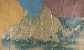 Shōhō Kuniezu - Suō Province, with Nagato in yellow, Iwami in blue, and Aki in pink (Yamaguchi Prefectural Archives)
 -
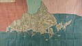 Genroku Kuniezu - Suō Province, with Nagato in red, Iwami in green, and Aki in pink (Yamaguchi Prefectural Archives)
 -
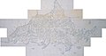 Tenpō Kuniezu - Suō Province (Yamaguchi Prefectural Archives)
 -
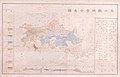 1878 map of Yamaguchi Prefecture, marked with its two constituent provinces of Suō (周防) and Nagato (長門), as well as neighbouring Iwami (石見) and Aki (安藝) (Yamaguchi Prefectural Archives)
,_shaden.jpg)


.jpg)
.jpg)
.jpg)
.jpg)
Notes
- .
- ^ "Nationwide List of Ichinomiya," p. 2; retrieved 2012-11-20.
- ^ Nussbaum, "Provinces and prefectures" at p. 780.
References
- Titsingh, Isaac. (1834). Annales des empereurs du Japon (Nihon Ōdai Ichiran). Paris: Royal Asiatic Society, Oriental Translation Fund of Great Britain and Ireland. OCLC 5850691.
External links
![]() Media related to Suo Province at Wikimedia Commons
Media related to Suo Province at Wikimedia Commons
34°03′28″N 131°35′11″E / 34.05778°N 131.58639°E
This article about a location in Yamaguchi Prefecture is a stub. You can help Wikipedia by expanding it. |