
Iyo Province

Iyo Province (伊予国, Iyo-no kuni) was a
Ōmishima in what is now part of Imabari.[2] The people spoke Iyo dialect
.

History
Iyo Province was formed by the
Edo Period. During the Heian period, the coastal areas of the province were part of the stronghold of Fujiwara no Sumitomo, who led a rebellion against Imperial authority. During the Muromachi period, a branch of the Saionji family was appointed as shugo by the Ashikaga shogunate, but was constantly being invaded his more powerful and aggressive neighbors. The Saionji survived by the fluid loyalties and fierce resistance, but were eventually overcome by Chōsokabe Motochika, who was in turn overthrown by the forces of Toyotomi Hideyoshi. [3] Under the Tokugawa shogunate
, the province was divided into several feudal domains.
| Name | Clan | Type | kokudaka |
|---|---|---|---|
| Hisamatsu-Matsudaira clan | Shinpan | 150,000 koku | |
| Date clan | Tozama |
100,000 koku | |
| Date clan | Tozama |
30,000 koku | |
| Katō clan | Tozama |
66,000 koku | |
| Katō clan | Tozama |
10,000 koku | |
| Hisamatsu-Matsudaira clan | Fudai |
35,000 koku | |
| Matsudaira clan | Shinpan | 30,000 koku | |
| Hitotsuyanagi clan | Tozama |
10,000 koku |
Per the early
Meiji period Kyudaka kyuryo Torishirabe-chō (旧高旧領取調帳), an official government assessment of the nation’s resources, the province had 964 villages with a total kokudaka of 434,408 koku
. Iyo Province consisted of the following districts:
| District | kokudaka | villages | status | Currently |
|---|---|---|---|---|
| Uma (宇摩郡) | 22,364 koku | 56 villages | Tenryō (18); Imabari (18), Saijō (11), Tenryō/Saijō (4), Tenryō/Imabari (1) | Dissolved, now Saijō, Shikoku-chūō |
| Nii (新居郡) | 36,694 koku | 53 villages | Tenryō (6); Komatsu (4), Saijō (43), | Dissolved; now Saijō, Niihama |
| Shūfu (周敷郡) | 23,142 koku | 38 villages | Iyo-Matsuyama (25), Komatsu (9), Saijō (2), Matsuyama/Komatsu (1), Komatsu/Saijō (1) | Dissolved; now Saijō, Tōon |
| Kuwamura (桑村郡) | 14,650 koku | 29 villages | Tenryō (4); Iyo-Matsuyama (23); Tenryō/Matsuyama (1) | Dissolved; now Saijō |
| Ochi (越智郡) | 46,790 koku | 106 villages | Tenryō (8); Imabari (83); Iyo-Matsuyama (17) | merged into Ōchi District on April 18, 1896, now Imabari, Kamijima |
| Noma (野間郡) | 16,587 koku | 29 villages | Iyo-Matsuyama (29) | merged into Ōchi District on April 18, 1896; now Imabari |
| Kazahaya (風早郡) | 18,351 koku | 84 villages | Tenryō (2); Iyo-Matsuyama (78); Ozu (4); Matsuyama/Ozu (1) | Dissolved, now Matsuyama |
| Wake (和気郡) | 16,345 koku | 25 villages | Iyo-Matsuyama (25) | Dissolved, now Matsuyama |
| Onsen (温泉郡) | 22,824 koku | 36 villages | Iyo-Matsuyama (36) | Dissolved, now Matsuyama, Toon |
| Kume (久米郡) | 17,554 koku | 32 villages | Iyo-Matsuyama (32) | Dissolved, now Matsuyama, Toon |
| Ukena (浮穴郡) | 38,834 koku | 102 villages | Iyo-Matsuyama (48); Ozu (46), Niiya (7); Matsuyama/Ozu (1); Ozu/Niiya (1) | Ozu, Seiyo, Uchiko, Iyo, Matsuyama, Toon, Tobe |
| Iyo (伊予郡) | 27,949 koku | 41 villages | Iyo-Matsuyama (22); Ozu (18), Niiya (2); Matsuyama/Ozu (1); Ozu/Niiya (1) | Masaki, Tobe, Iyo |
| Kita (喜多郡) | 33,491 koku | 83 villages | Ozu (82), Niiya (4); | Ozu, Iyo, Seiyo, Naishi |
Uwa (宇和郡) |
98,828 koku | 250 villages | Uwajima (140), Iyo-Yoshida (72); | Uwajima, Seiyo, Ozu, Naishi |
Following the abolition of the han system in 1871, Iyo Province became Ehime Prefecture.
Gallery
-
 Ōyamazumi Jinja, the ichinomiya of the province
 -
 Ōzu Castle
 -
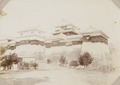 Matsuyama Castle, circa 1900-1902
 -
 Iyo Kokubun-ji


Notes
- .
- ^ "Nationwide List of Ichinomiya", p. 3.; retrieved 2011-08-09
- ISBN 978-4331802946.(in Japanese)
References
External links
![]() Media related to Iyo Province at Wikimedia Commons
Media related to Iyo Province at Wikimedia Commons