
Mimasaka Province

Mimasaka Province (美作国, Mimasaka-no kuni) was a province of Japan in the area that is northern Okayama Prefecture in the Chūgoku region of western Japan.[1][2] Mimasaka bordered Bitchū, Bizen, Harima, Hōki, and Inaba Provinces. Its abbreviated form name was Sakushū (作州). In terms of the Gokishichidō system, Mimasaka was one of the provinces of the San'in circuit. Under the Engishiki classification system, Mimasaka was ranked as one of the 35 "superior countries" (上国) in terms of importance, and one of the "near countries" (近国) in terms of distance from the capital. The provincial capital was located in what is now the city of Tsuyama.

Geography
Mimasaka was a landlocked province on the southern side of the
History
In 713, at the suggestion of Bizen-no-kami Nanten - and Bizen-no-suke Kamitsukeno-no-Kenji the Eita, Katsuta, Tomata, Kume, Mashima, and Oba districts of
During the
In 1871, following the abolition of the han system, Mimasaka was divided into Tsuyama, Mashima, Kurashiki, Tsuruta, Koromo, Koga, Ikuno, Akashi, Numata, and Tatsuno prefectures, which were merged with Okayama Prefecture inI 1876. Per the early
| Name | Clan | Type | kokudaka |
|---|---|---|---|
| Echizen-Matsudaira clan | Shinpan |
100,000 koku | |
| Miura clan | Fudai | 23,000 koku |
| District | kokudaka | Controlled by | at present | Comments |
|---|---|---|---|---|
| Aida District (英田郡) | 13,662 koku | 65 villages (51 tenryō, 3 Tsuyama Domain ) |
absorbed Yoshino District on April 1, 1900 | |
| Kumehokujō District (久米北条郡) | 28,871 koku | 60 villages (22 tenryō, 17 Hamada Domain, 11 Komoro Domain, 9 Tsuyama Domain, 1 Komoro/Tsuyama) |
merged with Kumenanjō District to become Kume District (久米郡) on April 1, 1890 | |
| Kumenanjō District (久米南条郡) | 22,989 koku | 72 villages (28 tenryō, 28 Koga Domain, 14 Tsuyama Domain, 1 Koga/Tsuyama, 1 tenryō/Tsuyama) |
merged with Kumehokujō District to become Kume District on April 1, 1890 | |
| Mashima District (真島郡) | 33,225 koku | 112 villages (107 Katsuyama Domain, 5 Tatsuno Domain) |
merged with Ōba District to become Maniwa District (真庭郡) on April 1, 1890 | |
| Ōba District (大庭郡) | 20,836 koku | 59 villages (32 Tsuyama Domain, 26 tenryō, 1 Tsuyama/tenryō) |
merged with Mashima District to become Maniwa District on April 1, 1890 | |
| Saihokujō District (西北条郡) | 11,582 koku | 34 villages 25 Tsuyama Domain, 9 tenryō) |
merged with Saisaijō, Tōhokujō and Tōnanjō Districts to become Tomata District (苫田郡) on April 1, 1890 | |
| Saisaijō District (西西条郡) | 27,308 koku | 61 villages (33 Tsuyama Domain, 32 tenryō) |
merged with Saihokujō, Tōhokujō and Tōnanjō Districts to become Tomata District on April 1, 1890 | |
| Shōboku District (勝北郡) | 34,189 koku | 89 villages (57 tenryō, 16 Tsuchiura Domain,10 Tsuyama Domain, 6 Numata Domain) |
merged with Shōnan District to become Katsuta District (勝田郡) on April 1, 1890 | |
| Shōnan District (勝南郡) | 24,657 koku | 79 villages (45 Tsuyama Domain, 31 tenryō, 3 Numata Domain) |
merged with Shōboku District to become Katsuta District on April 1, 1890 | |
| Tōhokujō District (東北条郡) | 15,411 koku | 40 villages (26 Tsuyama Domain, 15 tenryō) |
merged with Saihokujō, Saisaijō and Tōnanjō Districts to become Tomata District on April 1, 1890 | |
| Tōnanjō District (東南条郡) | 10,838 koku | 22 villages (22 Tsuyama Domain) |
merged with Saihokujō, Saisaijō and Tōhokujō Districts to become Tomata District on April 1, 1890 | |
| Yoshino District (吉野郡) | 19,954 koku | 73 villages (43 Akashi Domain, 19 tenryō, 7 Tsuyama Domain, 3 Tsuchiura Domain) |
merged into Aida District on April 1, 1900 |
Gallery
-
 Nakayama Jinja, the ichinomiya of the province
 -
 Matsudaira Yoshitomo, last daimyō of Tsushima
 -
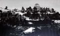 Tsuyama Castle in 1873
 -
 Site of the Mimasaka Kokufu


Notes
- .
- .
- ^ "Nationwide List of Ichinomiya," p. 3 Archived 2013-05-17 at the Wayback Machine; retrieved 2012-11-20.
References
External links
![]() Media related to Mimasaka Province at Wikimedia Commons
Media related to Mimasaka Province at Wikimedia Commons