
Summit Chief Mountain
| Summit Chief Mountain | |
|---|---|
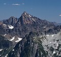
 Summit Chief Mountain, north aspect | |
| Highest point | |
| Elevation | 7,467 ft (2,276 m)[1] |
| Prominence | 1,323 ft (403 m)[1] |
| Parent peak | Chimney Rock[1] |
| Isolation | 1.29 mi (2.08 km)[1] |
| Coordinates | 47°31′24″N 121°16′06″W / 47.523426°N 121.268252°W[2] |
| Geography | |
 Summit Chief Mountain Location in Washington  Summit Chief Mountain Summit Chief Mountain (the United States) | |
| Country | United States |
| State | Washington |
| County | King / Kittitas |
| Protected area | Alpine Lakes Wilderness[3] |
| Parent range | Cascade Range |
| Topo map | USGS Big Snow Mountain |
| Climbing | |
| First ascent | 1925[4] |
| Easiest route | Scrambling[5] Southeast Face |
Summit Chief Mountain is a 7,467-foot (2,276-meter) mountain summit located on the county line separating
Climate
Summit Chief Mountain is located in the
Geology
The Alpine Lakes Wilderness features some of the most rugged topography in the
The history of the formation of the Cascade Mountains dates back millions of years ago to the late
During the Pleistocene period dating back over two million years ago, glaciation advancing and retreating repeatedly scoured the landscape leaving deposits of rock debris.[8] The last glacial retreat in the Alpine Lakes area began about 14,000 years ago and was north of the Canada–US border by 10,000 years ago.[8] The U-shaped cross section of the river valleys is a result of that recent glaciation. Uplift and faulting in combination with glaciation have been the dominant processes which have created the tall peaks and deep valleys of the Alpine Lakes Wilderness area.
Gallery
-
 West aspect from Big Snow Mountain
 -
 Summit Chief Mountain left of center, from Tank Lakes
 -
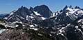 Left to rightː Little Big Chief, Middle Chief, Summit Chief, Chimney Rock, Overcoat
 -

-
 Summit Chief (center)


See also
References
- ^ a b c d "Summit Chief Mountain". ListsOfJohn.com. Retrieved 2024-04-10.
- ^ "Summit Chief Mountain". Geographic Names Information System. United States Geological Survey, United States Department of the Interior. Retrieved 2021-11-01.
- ^ a b "Summit Chief Mountain, Washington". Peakbagger.com.
- ^ ISBN 978-0898861273.
- ISBN 978-1594858406.
- ^ a b Beckey, p. 16
- ^ Smoot, Jeff (2004). Backpacking Washington’s Alpine Lakes Wilderness. Helena, Montana: The Globe Pequot Press.
- ^ a b c d e Kruckeberg, Arthur (1991). The Natural History of Puget Sound Country. University of Washington Press.