
User:Mdzafri
Affiliations
|
| Sub-pages |
|---|
| Sandbox |
To do list
- Use this bot for articles.
- Nihon and Indiaextremes.
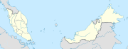
Do this or this to this.Kuala Lumpur state map similar to India's states.New version of File:Malaysia states named.png- State maps with divisions according to administrative districts. Remember to use Template:Subdivisions of Malaysia. Also use Template:Infobox settlement on all suitable locations.
- Category:Wikipedia requested maps in Malaysia
- Template:London as a reference to replace Template:Kuala Lumpur
- Template:LB Camden, Template:LB Enfield or any other borough as a reference for KL's divisions/constituencies
How to make SVG country maps
- Get map images for references. The more images the better(er). My main references are:
- Google Maps for Equirectangular maps.
- NASA World Windusing only the country boundary layer.
- The images are brought into Inkscape, and that's where the fun starts. Images from World Wind have to be arranged accordingly on top of equirectangular maps.
- World Wind images are then converted into vector with the Trace Bitmap function using procedures shown here.
- Herein starts the painstaking work of combining the Bézier lines to shape your map.
- Colour the map using colours suggested by Wikipedia:WikiProject Maps
Topo maps tutorials
- User:JaneVannin/translations
- Refer to this diagram for coordinates. Malaysia is between N0-N7 and E99-E120.
- Get maps from the Eurasia portion of the SRTM Database
- Wikipedia:Graphic Lab/Resources/Tutorials
Please cite GRASS when using the software in your work. Here are some choices depending on the version used:
- GRASS Development Team, 2009. Geographic Resources Analysis Support System (GRASS) Software, Version 6.4.0. http://grass.osgeo.org
Sources
References
- Use Template:Infobox settlement on all locations in Template:Kuala Lumpur
- Use Template:Location map for new location maps of states in Malaysia.
- Wikipedia:WikiProject Malaysia/Collaboration
- Wikipedia:WikiProject Malaysia/Cartography
- Andhra Pradesh for mapping inspiration.
- Template:Infobox Indian Jurisdiction
- Template:Location map Malaysia
- Template:Convert
Gallery
Completed works
-
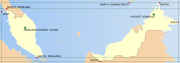 Extreme points of Malaysia.
 -

-
-
-

-


