
Vestvågøy
Vestvågøy Municipality
Vestvågøy kommune | |
|---|---|
 View of Ballstad in Vestvågøy | |
|
Coat of arms | |
 Nordland within Norway | |
 Vestvågøy within Nordland | |
| Coordinates: 68°13′17″N 13°47′04″E / 68.22139°N 13.78444°E | |
| Country | Norway |
| County | Nordland |
| District | Lofoten |
| Established | 1 Jan 1963 |
| • Preceded by | Borge, Buksnes, Hol, and Valberg |
| Administrative centre | Leknes |
| Government | |
| • Mayor (2023) | Jonny Finstad (H) |
| Area | |
| • Total | 424.29 km2 (163.82 sq mi) |
| • Land | 406.99 km2 (157.14 sq mi) |
| • Water | 17.30 km2 (6.68 sq mi) 4.1% |
| • Rank | #232 in Norway |
| Population (2023) | |
| • Total | 11,551 |
| • Rank | #99 in Norway |
| • Density | 28.4/km2 (74/sq mi) |
| • Change (10 years) | |
| Demonym | Vestvågøyværing[1] |
| Official language | |
| • Norwegian form | Neutral |
| Time zone | UTC+01:00 (CET) |
| • Summer (DST) | UTC+02:00 (CEST) |
| ISO 3166 code | NO-1860[3] |
| Website | Official website |
Vestvågøy is a municipality in Nordland county, Norway. It is part of the traditional district of Lofoten. The administrative centre of the municipality is the town of Leknes. Some of the villages in the municipality include Ballstad, Borg, Bøstad, Gravdal, Knutstad, Stamsund, and Tangstad. With over 11,300 inhabitants, Vestvågøy is the most populous municipality in all of the Lofoten and Vesterålen regions in Nordland county.
The
The 424-square-kilometre (164 sq mi) municipality is the 232nd largest by area out of the 356 municipalities in Norway. Vestvågøy is the 99th most populous municipality in Norway with a population of 11,551. The municipality's population density is 28.4 inhabitants per square kilometre (74/sq mi) and its population has increased by 6.3% over the previous 10-year period.[4][5]
General information
The municipality of Vestvågøy was created on 1 January 1963 when the four municipalities on the island of Vestvågøya were merged into one municipality for the whole island. The old municipalities on the island were Borge (population: 4,056), Buksnes (population: 4,416), Hol (population: 3,154), and Valberg (population: 662). Initially, Vestvågøy had 12,288 residents. The borders have not changed since.[6]
Name
The municipality is named after the island of Vestvågøya. The Old Norse name of the island was Lófót (see Lofoten), but when Lofoten became the name of the whole archipelago, the island became known as Vestvågøy. The first element of the name is the prefix vest which means "west". The middle element derives from the word vágr which means "bay" or "inlet". The last element is the definite form of the word øy which means "the island". Thus it means "the west bay island".[7]
Coat of arms
The
Churches
The
| Parish (sokn) | Church name | Location of the church | Year built |
|---|---|---|---|
| Borge | Borge Church | Bøstad | 1986 |
| Knutstad Chapel | Knutstad | 1915 | |
| Buksnes | Buksnes Church | Gravdal | 1905 |
| Hol | Hol Church | Leknes | 1806 |
| Stamsund | Stamsund Church | Stamsund | 1937 |
| Valberg | Valberg Church | Valberg | 1889 |
Geography

Vestvågøy municipality is among the most scenic in Norway. It encompassed the whole island of Vestvågøya with the
The coastline is dominated by high mountains, such as the 671-metre (2,201 ft) tall Skottinden, and on the west coast also sandy white beaches. Uttakleiv the most romantic beach in Europe, according to the British newspaper The Times, and the neighbouring Hauklandsstranden is ranked by the Norwegian newspaper Dagbladet as the best beach in Norway.
In Leknes, the sun (midnight sun) is above the horizon from May 26 until July 17, and in winter the sun does not rise from December 9 until January 4. The midnight sun is best viewed from the western beaches, such as Uttakleiv and Eggum.
Climate
There is an official weather station at Leknes Airport. Autumn and winter is much wetter than spring and summer. The driest month (July) get less than one fift of the precipitation in the wettest month (December).
| Climate data for Leknes Airport 1991–2020 | |||||||||||||
|---|---|---|---|---|---|---|---|---|---|---|---|---|---|
| Month | Jan | Feb | Mar | Apr | May | Jun | Jul | Aug | Sep | Oct | Nov | Dec | Year |
| Mean daily maximum °C (°F) | 1 (34) |
1 (34) |
2 (36) |
6 (43) |
10 (50) |
12 (54) |
16 (61) |
15 (59) |
12 (54) |
8 (46) |
4 (39) |
3 (37) |
8 (46) |
| Daily mean °C (°F) | 0 (32) |
−0.6 (30.9) |
0 (32) |
2.8 (37.0) |
6.5 (43.7) |
9.9 (49.8) |
12.8 (55.0) |
12.2 (54.0) |
9.4 (48.9) |
5.2 (41.4) |
2.6 (36.7) |
1 (34) |
5.2 (41.3) |
| Mean daily minimum °C (°F) | −2 (28) |
−2 (28) |
−2 (28) |
1 (34) |
4 (39) |
8 (46) |
11 (52) |
10 (50) |
7 (45) |
4 (39) |
2 (36) |
0 (32) |
3 (38) |
| Average precipitation mm (inches) | 203 (8.0) |
174 (6.9) |
161 (6.3) |
93 (3.7) |
74 (2.9) |
45 (1.8) |
38 (1.5) |
78 (3.1) |
123 (4.8) |
161 (6.3) |
173 (6.8) |
223 (8.8) |
1,546 (60.9) |
| Source: Weatheronline climate robot (avg highs/lows) [11] | |||||||||||||
| Climate data for Kvalnes, on northern Vestvågøya 1961-90 | |||||||||||||
|---|---|---|---|---|---|---|---|---|---|---|---|---|---|
| Month | Jan | Feb | Mar | Apr | May | Jun | Jul | Aug | Sep | Oct | Nov | Dec | Year |
| Mean daily maximum °C (°F) | 1.8 (35.2) |
1.4 (34.5) |
2.1 (35.8) |
4.4 (39.9) |
8.6 (47.5) |
12.2 (54.0) |
14.1 (57.4) |
14.0 (57.2) |
10.8 (51.4) |
7.3 (45.1) |
4.2 (39.6) |
2.5 (36.5) |
7.0 (44.6) |
| Daily mean °C (°F) | −0.2 (31.6) |
−0.3 (31.5) |
0.4 (32.7) |
2.6 (36.7) |
6.5 (43.7) |
9.5 (49.1) |
11.5 (52.7) |
11.9 (53.4) |
8.9 (48.0) |
5.7 (42.3) |
2.5 (36.5) |
0.5 (32.9) |
5.0 (41.0) |
| Mean daily minimum °C (°F) | −2.5 (27.5) |
−2.8 (27.0) |
−2.0 (28.4) |
0.2 (32.4) |
3.8 (38.8) |
7.2 (45.0) |
9.5 (49.1) |
9.7 (49.5) |
6.9 (44.4) |
3.5 (38.3) |
0.3 (32.5) |
−1.8 (28.8) |
2.7 (36.9) |
| Average precipitation mm (inches) | 117 (4.6) |
93 (3.7) |
89 (3.5) |
70 (2.8) |
48 (1.9) |
50 (2.0) |
71 (2.8) |
68 (2.7) |
111 (4.4) |
153 (6.0) |
126 (5.0) |
139 (5.5) |
1,135 (44.7) |
| Average precipitation days (≥ 1.0 mm) | 16.2 | 14.2 | 15.1 | 11.7 | 8.9 | 9.9 | 11.5 | 11.0 | 15.8 | 18.0 | 18.2 | 17.7 | 168.2 |
| Source: Norwegian Meteorological Institute[12] | |||||||||||||

Government
All municipalities in Norway are responsible for
Municipal council
The
| Party name (in Norwegian) | Number of representatives | |
|---|---|---|
| Labour Party (Arbeiderpartiet) | 7 | |
| Progress Party (Fremskrittspartiet) | 8 | |
| Green Party (Miljøpartiet De Grønne) | 1 | |
| Conservative Party (Høyre) | 7 | |
| Christian Democratic Party (Kristelig Folkeparti) | 2 | |
| Norway Democrats (Norgesdemokratene) | 1 | |
Red Party (Rødt) |
1 | |
| Centre Party (Senterpartiet) | 3 | |
| Socialist Left Party (Sosialistisk Venstreparti) | 2 | |
| Liberal Party (Venstre) | 1 | |
| Total number of members: | 33 | |
| Party name (in Norwegian) | Number of representatives | |
|---|---|---|
| Labour Party (Arbeiderpartiet) | 8 | |
| Progress Party (Fremskrittspartiet) | 5 | |
| Green Party (Miljøpartiet De Grønne) | 1 | |
| Conservative Party (Høyre) | 4 | |
| Christian Democratic Party (Kristelig Folkeparti) | 2 | |
Red Party (Rødt) |
1 | |
| Centre Party (Senterpartiet) | 10 | |
| Socialist Left Party (Sosialistisk Venstreparti) | 2 | |
| Total number of members: | 33 | |
| Party name (in Norwegian) | Number of representatives | |
|---|---|---|
| Labour Party (Arbeiderpartiet) | 11 | |
| Progress Party (Fremskrittspartiet) | 3 | |
| Green Party (Miljøpartiet De Grønne) | 1 | |
| Conservative Party (Høyre) | 8 | |
| Christian Democratic Party (Kristelig Folkeparti) | 2 | |
| Centre Party (Senterpartiet) | 5 | |
| Socialist Left Party (Sosialistisk Venstreparti) | 2 | |
| Liberal Party (Venstre) | 1 | |
| Total number of members: | 33 | |
| Party name (in Norwegian) | Number of representatives | |
|---|---|---|
| Labour Party (Arbeiderpartiet) | 10 | |
| Progress Party (Fremskrittspartiet) | 4 | |
| Green Party (Miljøpartiet De Grønne) | 1 | |
| Conservative Party (Høyre) | 10 | |
| Christian Democratic Party (Kristelig Folkeparti) | 3 | |
| Centre Party (Senterpartiet) | 4 | |
| Socialist Left Party (Sosialistisk Venstreparti) | 2 | |
| Liberal Party (Venstre) | 1 | |
| Total number of members: | 35 | |
| Party name (in Norwegian) | Number of representatives | |
|---|---|---|
| Labour Party (Arbeiderpartiet) | 8 | |
| Progress Party (Fremskrittspartiet) | 5 | |
| Conservative Party (Høyre) | 8 | |
| Christian Democratic Party (Kristelig Folkeparti) | 4 | |
| Coastal Party (Kystpartiet) | 1 | |
| Centre Party (Senterpartiet) | 6 | |
| Socialist Left Party (Sosialistisk Venstreparti) | 2 | |
| Vestvågøy list (Vestvågøylista) | 1 | |
| Total number of members: | 35 | |
| Party name (in Norwegian) | Number of representatives | |
|---|---|---|
| Labour Party (Arbeiderpartiet) | 7 | |
| Progress Party (Fremskrittspartiet) | 6 | |
| Conservative Party (Høyre) | 3 | |
| Christian Democratic Party (Kristelig Folkeparti) | 4 | |
| Coastal Party (Kystpartiet) | 1 | |
| Centre Party (Senterpartiet) | 6 | |
| Socialist Left Party (Sosialistisk Venstreparti) | 4 | |
| Joint list of the Red Electoral Alliance (Rød Valgallianse) and the Communist Party (Kommunistiske Parti) | 1 | |
| Vestvågøy list (Vestvågøylista) | 3 | |
| Total number of members: | 35 | |
| Party name (in Norwegian) | Number of representatives | |
|---|---|---|
| Labour Party (Arbeiderpartiet) | 7 | |
| Progress Party (Fremskrittspartiet) | 6 | |
| Conservative Party (Høyre) | 3 | |
| Christian Democratic Party (Kristelig Folkeparti) | 6 | |
| Coastal Party (Kystpartiet) | 1 | |
| Centre Party (Senterpartiet) | 6 | |
| Socialist Left Party (Sosialistisk Venstreparti) | 2 | |
| Joint list of the Red Electoral Alliance (Rød Valgallianse) and the Communist Party (Kommunistiske Parti) | 1 | |
| Vestvågøy list (Vestvågøylista) | 3 | |
| Total number of members: | 35 | |
| Party name (in Norwegian) | Number of representatives | |
|---|---|---|
| Labour Party (Arbeiderpartiet) | 5 | |
| Progress Party (Fremskrittspartiet) | 5 | |
| Conservative Party (Høyre) | 3 | |
| Christian Democratic Party (Kristelig Folkeparti) | 6 | |
| Centre Party (Senterpartiet) | 11 | |
| Socialist Left Party (Sosialistisk Venstreparti) | 1 | |
| Vestvågøy list (Vestvågoylista) | 4 | |
| Total number of members: | 35 | |
| Party name (in Norwegian) | Number of representatives | |
|---|---|---|
| Labour Party (Arbeiderpartiet) | 9 | |
| Progress Party (Fremskrittspartiet) | 2 | |
| Conservative Party (Høyre) | 7 | |
| Christian Democratic Party (Kristelig Folkeparti) | 5 | |
| Pensioners' Party (Pensjonistpartiet) | 1 | |
| Centre Party (Senterpartiet) | 12 | |
| Socialist Left Party (Sosialistisk Venstreparti) | 4 | |
| Hol and Valberg district list (Hol og Valberg Distriktliste) | 3 | |
| Total number of members: | 43 | |
| Party name (in Norwegian) | Number of representatives | |
|---|---|---|
| Labour Party (Arbeiderpartiet) | 13 | |
| Progress Party (Fremskrittspartiet) | 2 | |
| Conservative Party (Høyre) | 9 | |
| Christian Democratic Party (Kristelig Folkeparti) | 6 | |
| Pensioners' Party (Pensjonistpartiet) | 1 | |
| Centre Party (Senterpartiet) | 5 | |
| Socialist Left Party (Sosialistisk Venstreparti) | 2 | |
| Hol and Valberg district list (Hol og Valberg distriktsliste) | 5 | |
| Total number of members: | 43 | |
| Party name (in Norwegian) | Number of representatives | |
|---|---|---|
| Labour Party (Arbeiderpartiet) | 15 | |
| Progress Party (Fremskrittspartiet) | 1 | |
| Conservative Party (Høyre) | 8 | |
| Christian Democratic Party (Kristelig Folkeparti) | 5 | |
| Centre Party (Senterpartiet) | 7 | |
| Socialist Left Party (Sosialistisk Venstreparti) | 1 | |
| Liberal Party (Venstre) | 1 | |
| For the referendum (For Folkeavstemning) | 1 | |
| Hol and Valberg district list (Hol og Valberg distriktslista) | 4 | |
| Total number of members: | 43 | |
| Party name (in Norwegian) | Number of representatives | |
|---|---|---|
| Labour Party (Arbeiderpartiet) | 15 | |
| Progress Party (Fremskrittspartiet) | 2 | |
| Conservative Party (Høyre) | 8 | |
| Christian Democratic Party (Kristelig Folkeparti) | 7 | |
| Centre Party (Senterpartiet) | 6 | |
| Socialist Left Party (Sosialistisk Venstreparti) | 1 | |
| Liberal Party (Venstre) | 1 | |
| Hol and Valberg district list (Hol og Valberg distriktsliste) | 3 | |
| Total number of members: | 43 | |
| Party name (in Norwegian) | Number of representatives | |
|---|---|---|
| Labour Party (Arbeiderpartiet) | 16 | |
Anders Lange's Party (Anders Langes parti) |
3 | |
| Conservative Party (Høyre) | 5 | |
| Christian Democratic Party (Kristelig Folkeparti) | 8 | |
| Centre Party (Senterpartiet) | 9 | |
| Socialist Left Party (Sosialistisk Venstreparti) | 1 | |
| Liberal Party (Venstre) | 1 | |
| Total number of members: | 43 | |
| Party name (in Norwegian) | Number of representatives | |
|---|---|---|
| Labour Party (Arbeiderpartiet) | 18 | |
| Conservative Party (Høyre) | 5 | |
| Christian Democratic Party (Kristelig Folkeparti) | 4 | |
| Centre Party (Senterpartiet) | 8 | |
| Socialist People's Party (Sosialistisk Folkeparti) | 1 | |
| Liberal Party (Venstre) | 1 | |
| Local List(s) (Lokale lister) | 6 | |
| Total number of members: | 43 | |
| Party name (in Norwegian) | Number of representatives | |
|---|---|---|
| Labour Party (Arbeiderpartiet) | 17 | |
| Conservative Party (Høyre) | 7 | |
| Christian Democratic Party (Kristelig Folkeparti) | 3 | |
| Centre Party (Senterpartiet) | 7 | |
| Socialist People's Party (Sosialistisk Folkeparti) | 2 | |
| Liberal Party (Venstre) | 2 | |
| Local List(s) (Lokale lister) | 5 | |
| Total number of members: | 43 | |
| Party name (in Norwegian) | Number of representatives | |
|---|---|---|
| Labour Party (Arbeiderpartiet) | 24 | |
| Conservative Party (Høyre) | 10 | |
| Christian Democratic Party (Kristelig Folkeparti) | 4 | |
| Centre Party (Senterpartiet) | 9 | |
| Socialist People's Party (Sosialistisk Folkeparti) | 1 | |
| Liberal Party (Venstre) | 3 | |
| Local List(s) (Lokale lister) | 2 | |
| Total number of members: | 53 | |
Mayors
- 1963-1963: Alsing Wik (H)
- 1964–1967: Walter Tjønndal (Ap)
- 1968–1969: Boy Rist (H)
- 1970–1971: Karl Leirfall (Sp)
- 1972–1973: Eivind Bolle (Ap)
- 1974–1975: Johannes Sundrønning (Ap)
- 1976–1977: Petter Limstrand (Sp)
- 1978–1981: Johannes Sundrønning (Ap)
- 1982–1983: Petter Limstrand (Sp)
- 1984–1987: Søren Fredrik Voie (H)
- 1988–1991: Karl Sverre Klevstad (KrF)
- 1992–1999: Frank Rist (Sp)
- 1999–2007: Guri Ingebrigtsen (Ap)
- 2007–2015: Jonny Finstad (H)
- 2015–2023: Remi Solberg (Ap)
- 2023–present: Jonny Finstad (H)
Transportation
,_Vestv%C3%A5g%C3%B8y_municipality,_Lofoten,_Nordland,_Norway.JPG)
Leknes is the municipal and
The
International relations
Twin towns – Sister cities
Vestvågøy is
Notable people

- Hartvig Jentoft (1693 in Borge – 1739), a Norwegian tradesman and sailor
- Karl Uchermann (1855 in Borge – 1940), a Norwegian painter of dogs and altarpieces
- Mikael Heggelund Foslie (1855 in Borge – 1909), a botanist and algaeologist
- Jens R. Nilssen (1880 in Valberg – 1964), a Norwegian illustrator, comics creator, and cartoonist
- Edvarda Lie (1910–1963), a painter, drawer, and illustrator who was brought up in Vestvågøy
- Boy Rist (1912 in Gravdal – 1972), a naval officer and member of the Norwegian resistance in WWII
- Harald Sverdrup (1923 in Gravdal – 1992), a Norwegian poet and children's writer
- Kari Wærness (born 1939 in Leknes), a Norwegian sociologist
- Søren Fredrik Voie (born 1949 in Vestvågøy), a politician who was Mayor of Vestvågøy from 1983-1987
- Guri Ingebrigtsen (1952–2020), a Norwegian politician who was Mayor of Vestvågøy from 1999 to 2007
- Prince Karim Aga Khanwho bought a house in Unstad in 2019
Media gallery
-
 Unstad; Vestvågøy has the largest areas of lowland in Lofoten
 -
 View south-west from the summit of Bulitinden
 -
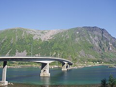 Sundklakkstraumen Bridge
 -
 Near Borg in Vestvågøy
 -
 The mountain Skottinden in winter sunshine


References
- ^ "Navn på steder og personer: Innbyggjarnamn" (in Norwegian). Språkrådet.
- ^ "Forskrift om målvedtak i kommunar og fylkeskommunar" (in Norwegian). Lovdata.no.
- Store norske leksikon (in Norwegian). Kunnskapsforlaget.
- ^ Statistisk sentralbyrå. "Table: 06913: Population 1 January and population changes during the calendar year (M)" (in Norwegian).
- ^ Statistisk sentralbyrå. "09280: Area of land and fresh water (km²) (M)" (in Norwegian).
- ^ Jukvam, Dag (1999). "Historisk oversikt over endringer i kommune- og fylkesinndelingen" (PDF) (in Norwegian). Statistisk sentralbyrå.
- Store norske leksikon (in Norwegian). Kunnskapsforlaget. Retrieved 19 November 2023.
- ^ "Civic heraldry of Norway - Norske Kommunevåpen". Heraldry of the World. Retrieved 5 February 2023.
- ^ "Vestvågøy, Nordland (Norway)". Flags of the World. Retrieved 5 February 2023.
- ^ "Godkjenning av våpen og flagg". Lovdata.no (in Norwegian). Norges kommunal- og arbeidsdepartementet. 23 November 1984. Retrieved 5 February 2023.
- ^ "Weatheronline climate robot Leknes Airport". Weather online. Retrieved 27 March 2021.
- ^ "eKlima Web Portal". Norwegian Meteorological Institute. Archived from the original on 14 June 2004.
- Store norske leksikon (in Norwegian). Kunnskapsforlaget. Retrieved 14 October 2022.
- ^ "Kommunestyrevalg 2023 - Nordland". Valg Direktoratet. Retrieved 27 December 2023.
- ^ "Tall for Norge: Kommunestyrevalg 2019 - Nordland". Valg Direktoratet. Retrieved 28 October 2019.
- ^ a b c d "Table: 04813: Members of the local councils, by party/electoral list at the Municipal Council election (M)" (in Norwegian). Statistics Norway.
- ^ "Tall for Norge: Kommunestyrevalg 2011 - Nordland". Valg Direktoratet. Retrieved 28 October 2019.
- ^ "Kommunestyrevalget 1995" (PDF) (in Norwegian). Oslo-Kongsvinger: Statistisk sentralbyrå. 1996. Retrieved 18 March 2020.
- ^ "Kommunestyrevalget 1991" (PDF) (in Norwegian). Oslo-Kongsvinger: Statistisk sentralbyrå. 1993. Retrieved 18 March 2020.
- ^ "Kommunestyrevalget 1987" (PDF) (in Norwegian). Oslo-Kongsvinger: Statistisk sentralbyrå. 1988. Retrieved 18 March 2020.
- ^ "Kommunestyrevalget 1983" (PDF) (in Norwegian). Oslo-Kongsvinger: Statistisk sentralbyrå. 1984. Retrieved 18 March 2020.
- ^ "Kommunestyrevalget 1979" (PDF) (in Norwegian). Oslo: Statistisk sentralbyrå. 1979. Retrieved 18 March 2020.
- ^ "Kommunevalgene 1975" (PDF) (in Norwegian). Oslo: Statistisk sentralbyrå. 1977. Retrieved 18 March 2020.
- ^ "Kommunevalgene 1972" (PDF) (in Norwegian). Oslo: Statistisk sentralbyrå. 1973. Retrieved 18 March 2020.
- ^ "Kommunevalgene 1967" (PDF) (in Norwegian). Oslo: Statistisk sentralbyrå. 1967. Retrieved 18 March 2020.
- ^ "Kommunevalgene 1963" (PDF) (in Norwegian). Oslo: Statistisk sentralbyrå. 1964. Retrieved 18 March 2020.
- ^ Hope, Johannes, ed. (1993). Vestvågøy kommune... - gjennom 30 år (in Norwegian). Vestvågøy Kommune. pp. 30 & 48.
- ^ "Twin municipalities Norway-Iceland" (in Norwegian). Norwegian government. Retrieved 24 April 2012.
External links
 Nordland travel guide from Wikivoyage
- Municipal fact sheet from Statistics Norway (in Norwegian)
| |||||||||||
 | Towns and cities |
| |||||||||
| Municipalities |
| ||||||||||
| |||||||||||
| Authority control databases: Geographic |
|---|