
Waldeck, Hesse
Waldeck | |
|---|---|
 Waldeck seen from the northeast | |
_COA.svg) Coat of arms | |
Location of Waldeck within Waldeck-Frankenberg district 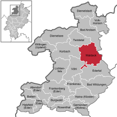 | |
Stadtteile | |
| Government | |
| • Mayor (2018–24) | Jürgen Vollbracht[1] (CDU) |
| Area | |
| • Total | 115.73 km2 (44.68 sq mi) |
| Highest elevation | 475 m (1,558 ft) |
| Lowest elevation | 245 m (804 ft) |
| Population (2022-12-31)[2] | |
| • Total | 6,810 |
| • Density | 59/km2 (150/sq mi) |
| Time zone | UTC+01:00 (CET) |
| • Summer (DST) | UTC+02:00 (CEST) |
| Postal codes | 34513 |
| Dialling codes | 05634 |
| Vehicle registration | KB |
| Website | www.waldeck.de |
Waldeck is a small town in Waldeck-Frankenberg district in northwestern Hesse, Germany. Its located near the Edersee, which is a popular destination for tourists and locals alike.
Geography
Location
Waldeck lies on the
Neighbouring communities
Waldeck borders in the north on the community of Twistetal, in the northeast on the town of Bad Arolsen (both in Waldeck-Frankenberg), in the east on the towns of Wolfhagen and Naumburg (both in the district of Kassel), in the south on the community of Edertal, and in the west on the community of Vöhl and the town of Korbach (all three in Waldeck-Frankenberg).
Constituent communities
The town of Waldeck consists of the centres of Alraft, Dehringhausen, Freienhagen, Höringhausen, Netze, Nieder-Werbe, Ober-Werbe, Sachsenhausen, Selbach and Waldeck.
History
The first evidence of settlement at Waldeck comes from the year 1232 when a document from the Netze Monastery mentioned the universitas civitatis de waldeke. Until 1254, the town was also called Rode, possibly because there was a clearing there. The town's first seal was acquired in 1266, and the town had its first historically verifiable mayor in 1311. Until the beginning of the 20th century, Waldeck's population barely exceeded 400.
Waldeck was the residence of the
The Edersee, Germany's third largest reservoir, was created by the construction of the Eder
Freienhagen
Until municipal reforms in 1974, Freienhagen was a town in its own right. It already had town rights when history first mentioned the town in 1253; it is believed that they were granted in 1231. On the Hünenburg, a 472 m-high mountain in the Freienhagen Municipal Forest, traces of a prehistoric settlement have been found.
In the
Amalgamations
As part of municipal reforms, the greater town of Waldeck was formed out of the formerly independent communities of Alraft, Höringhausen, Netze, Nieder-Werbe, Selbach, Sachsenhausen and Waldeck. In 1974, Dehringhausen, Freienhagen and Ober-Werbe also joined the town.
Politics
Town council
The town council's 31 seats are apportioned thus, in accordance with municipal elections held on 6 March 2016:
| SPD | 8 seats |
CDU |
10 seats |
| FWG | 6 seats |
| FDP | 3 seats |
Greens |
4 seat |
Note: FWG is a citizens' coalition.
The town's executive consists of 7 councillors. Three of these seats are held by the SPD, 2 by the CDU, and one seat each by the FWG and the FDP.
Mayoral elections are held every six years. The most recent mayors were:[1]
- 2018–incumbent: Jürgen Vollbracht (CDU)
- 2006–2018: Jörg Feldmann (independent)
- 1994–2006: Peter Brandenburg (SPD)
Coat of arms
The official blazon roughly translates thus: In Or a six-pointed star sable.
This simply describes a black six-pointed star on a gold background, with no mention at all of the
According to this same source, the star was originally eight-pointed, as commonly appears in many civic arms in the Waldeck region. It is an heraldic charge once borne by the Counts of Waldeck in the Middle Ages. The number of points was changed in the 19th century to distinguish the town's arms from the district's.
Town partnerships
 Blankenhain, Thuringia, since 1990
Culture and sightseeing
Museums
- Heimatmuseum Höringhausen (local history)
- Dorfstube Nieder-Werbe
Buildings

- Schloss Waldeck, stately home, and the town's landmark
- Netze monastery church with an altar from the 14th century
- Sachsenhäuser Warte (watchtower in Sachsenhausen)
- Edertalsperre (dam)
- Romanesque "fortress church" with onion domes in Freienhagen
- half-timbered houses in Freienhagen
- Old mills near Freienhagen
Parks
- Uferpromenade Waldeck (shoreline promenade)
Sport
- Golf courses north of town: 18-hole championship course and 9-hole short course
Economy and infrastructure
Transport
Through the town run the Federal Highways (Bundesstraßen) B 251 and B 485.
Operations on the stretch of the Ederseebahn
There is a cableway to the Edersee and well built hiking trails in the Kellerwald-Edersee National Park.
References
- ^ Hessisches Statistisches Landesamt. 5 September 2022.
- Hessisches Statistisches Landesamt. June 2023.
External links
- Waldeck
- Schloss Waldeck
- Edersee holiday region
- History of the Principality of Waldeck
- Waldeck at Curlie
Towns and municipalities in Waldeck-Frankenberg district | ||
|---|---|---|
 | ||
| Authority control databases: National |
|---|