
Wriezen
Wriezen | |
|---|---|
 Town hall | |
 Coat of arms | |
Location of Wriezen within Märkisch-Oderland district 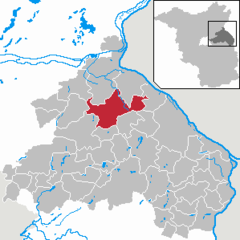 | |
Ortsteile | |
| Government | |
| • Mayor (2017–25) | Karsten Ilm[1] (CDU) |
| Area | |
| • Total | 94.54 km2 (36.50 sq mi) |
| Elevation | 10 m (30 ft) |
| Population (2022-12-31)[2] | |
| • Total | 7,221 |
| • Density | 76/km2 (200/sq mi) |
| Time zone | UTC+01:00 (CET) |
| • Summer (DST) | UTC+02:00 (CEST) |
| Postal codes | 16269 |
| Dialling codes | 033456 |
| Vehicle registration | MOL |
| Website | www.wriezen.de |
Wriezen (German pronunciation: [ˈvʁiːt͡sn̩] ⓘ) is a town in the district Märkisch-Oderland, in Brandenburg, in north-eastern Germany, near the border with Poland. It is situated 11 km (7 mi) southeast of Bad Freienwalde.
Etymology
The name is of medieval Slavic Lechitic origin, and comes from the words we and rice or rika (modern Polish: rzeka, Lower Sorbian: rěka), which means "on the river".[3] The modern Polish name is Wrzecień.[4]
History
From 1373 to 1411, it was part of the Bohemian (Czech) Crown under the House of Luxembourg.[5] In 1375, the town's privileges were confirmed on the condition, that the Bohemian Kings could build a fortress in the town without any obstacles.[5]
From 1701, Wriezen was part of the
Demography
-
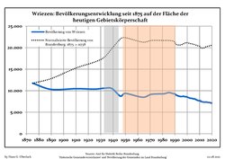 Development of Population since 1875 within the Current Boundaries (Blue Line: Population; Dotted Line: Comparison to Population Development of Brandenburg state; Grey Background: Time of Nazi rule; Red Background: Time of Communist rule)
 -
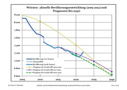 Recent Population Development and Projections (Population Development before Census 2011 (blue line); Recent Population Development according to the Census in Germany in 2011 (blue bordered line); Official projections for 2005-2030 (yellow line); for 2017-2030 (scarlet line); for 2020-2030 (green line)


|
|
|
Photogallery
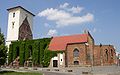
- St. Mary’s Church
-
-


- Haselberg
-
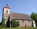 Church
 -
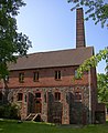 Distillery
 -
-
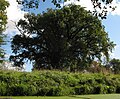
 Fieldstone wall
 -
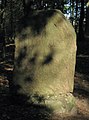 Grave of horse Pipifax
 -
 Sparkasse (Savings bank)


Notable people
- Henning von Boehmer (born 1943), journalist and commercial lawyer, former general secretary of the International Chamber of Commerce - Germany (ICC)
- Cornelia Froboess (born 1943), actress, teen idol and pop singer
- Michael Succow (born 1941), biologist and agronomist, an honorary citizen of the municipality Lüdersdorf / Biesdorf, now district Wriezen
See also
References
- ^ Landkreis Märkisch-Oderland Wahl der Bürgermeisterin / des Bürgermeisters, accessed 1 July 2021.
- Amt für Statistik Berlin-Brandenburg(in German). June 2023.
- ^ Ulrich, Christian Samuel (1830). Beschreibung der Stadt Wriezen und ihrer Umgegend, in historisch-statistisch-topographischer Beziehung (in German). Berlin. pp. 15–16.
- ^ Wojskowy Instytut Geograficzny Sztabu Generalnego W.P. (1947). "Legnica" (Map). Mapa Polski. 1:500,000 (in Polish).
- ^ a b Ulrich, p. 32
- ISBN 978-83-11-10357-3.
- ^ Detailed data sources are to be found in the Wikimedia Commons.Population Projection Brandenburg at Wikimedia Commons
External links
![]() Media related to Wriezen at Wikimedia Commons
Media related to Wriezen at Wikimedia Commons
| International | |
|---|---|
| National | |
| Geographic | |
This Brandenburg location article is a stub. You can help Wikipedia by expanding it. |