
Fredersdorf-Vogelsdorf
Fredersdorf-Vogelsdorf | |
|---|---|
 Vogelsdorf's church | |
 Coat of arms | |
Location of Fredersdorf-Vogelsdorf within Märkisch-Oderland district  | |
Ortsteile | |
| Government | |
| • Mayor (2015–23) | Thomas Krieger[1] (CDU) |
| Area | |
| • Total | 16.36 km2 (6.32 sq mi) |
| Elevation | 53 m (174 ft) |
| Population (2022-12-31)[2] | |
| • Total | 14,613 |
| • Density | 890/km2 (2,300/sq mi) |
| Time zone | UTC+01:00 (CET) |
| • Summer (DST) | UTC+02:00 (CEST) |
| Postal codes | 15370 |
| Dialling codes | 033439 |
| Vehicle registration | MOL |
| Website | www.fredersdorf-vogelsdorf.de |
Fredersdorf-Vogelsdorf is a municipality in the district Märkisch-Oderland, in Brandenburg, Germany.
Geography
The municipality, situated 23 km east of
Vogelsdorf
.
Demography
-
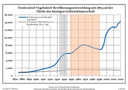 Development of Population since 1875 within the Current Boundaries (Blue Line: Population; Dotted Line: Comparison to Population Development of Brandenburg state; Grey Background: Time of Nazi rule; Red Background: Time of GDR rule)
 -
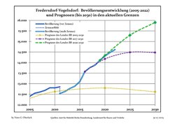 Recent Population Development and Projections (Population Development before Census 2011 (blue line); Recent Population Development according to the Census in Germany in 2011 (blue bordered line); Official projections for 2005-2030 (yellow line); for 2017-2030 (scarlet line); for 2020-2030 (green line)


|
|
|
Transport
The village is well connected to Berlin by the S-Bahn line S5 at the station of Fredersdorf.
Twin towns
Fredersdorf-Vogelsdorf is
twinned
with:
 Marquette-lez-Lille (France)
 Sleaford, Lincolnshire, England (since 2009)[4]
References
- ^ Landkreis Märkisch-Oderland Wahl der Bürgermeisterin / des Bürgermeisters, accessed 1 July 2021.
- Amt für Statistik Berlin-Brandenburg(in German). June 2023.
- ^ Detailed data sources are to be found in the Wikimedia Commons.Population Projection Brandenburg at Wikimedia Commons
- ^ "Home - Why not get involved with twinning". Sleaford, Lincolnshire, United Kingdom: Sleaford & District Twinning Association. Archived from the original on 6 January 2015. Retrieved 29 April 2012.
External links
![]() Media related to Fredersdorf-Vogelsdorf at Wikimedia Commons
Media related to Fredersdorf-Vogelsdorf at Wikimedia Commons
| International | |
|---|---|
| National | |
| Geographic | |
This Brandenburg location article is a stub. You can help Wikipedia by expanding it. |