
Zuni Indian Reservation
Pueblo of Zuni
Ashiwi ( Reservation | |
|---|---|
 | |
 | |
| Country | United States |
| State | New Mexico, Arizona |
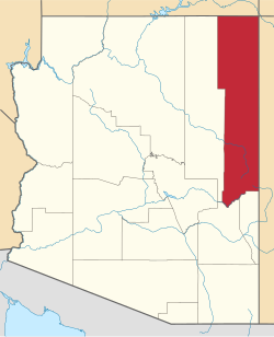
| County | McKinley, Cibola, Apache County, Arizona |
| Government | |
| • Governor | Val Panteah |
| Population (2000)Enrolled tribal members | |
• Total | 7,758 |
| Time zone | MT/MDT |
| Website | Official site of the Zuni tribe |
The Zuni Indian Reservation, also known as Pueblo of Zuni, is the homeland of the Zuni tribe of Native Americans. In Zuni language, the Zuni Pueblo people are referred to as A:shiwi, and the Zuni homeland is referred to as Halona Idiwan’a meaning Middle Place.[1]
Location

The reservation lies in the
The main part of the reservation borders the state of
As noted above, the Zuni Tribe also has land holdings in Apache County, Arizona, and Catron County, New Mexico, that do not border the main reservation.
Population
The population was reported at 7,891 inhabitants in the

History and main features
Also on the main reservation are the Hawikuh Ruins. The ancient Zuni pueblo of Hawikuh was the largest of the Seven Cities of Cibola. It was established in the 13th century and abandoned in 1680. It was also the first pueblo seen by the Spanish explorers. The African scout Estevanico was the first non-Native to reach this area.
The largest town on the reservation is
Tribal government
The Zuni Tribe is governed by an elected governor, lieutenant governor, and a six-member
Education
The sections in Cibola and McKinley counties in New Mexico are zoned to the
is the zoned high school.See also
Bibliography
- Zuni Reservation and Off-Reservation Trust Land, New Mexico/Arizona United States Census Bureau
References
- ^ "Experience Zuni". www.zunitourism.com. Retrieved 2017-11-08.
- ^ "New Mexico What the Data Show" (PDF). U.S. Census Bureau Population and Housing Occupancy Status: State - American Indian Area. July 22, 2011. Archived from the original (PDF) on May 22, 2014. Retrieved May 22, 2014.
- U.S. Census Bureau. Retrieved 2021-07-20.
- U.S. Census Bureau. Retrieved 2021-07-20.
External links
See also: Indigenous peoples of Arizona |
| Reservations | |
|---|---|
| Pueblos | |
 | ||||
Towns | ||||
| CDPs |
| |||
| Populated places | ||||
| Indian reservations | ||||
Ghost towns | ||||
| Footnotes | ‡This populated place also has portions in an adjacent county or counties | |||
| ||||
 | ||||
| CDPs |
| |||
| Other communities | ||||
| Indian reservation | ||||
| Footnotes | ‡This populated place also has portions in an adjacent county or counties | |||
| ||||
Municipalities and communities of Cibola County, New Mexico, United States | ||
|---|---|---|
| City |  | |
| Village | ||
| CDPs |
| |
| Other communities | ||
| Indian reservations | ||
| Footnotes | ‡This populated place also has portions in an adjacent county or counties | |
| ||