
Alangiri
Alangiri | ||
|---|---|---|
Village | ||
District Purba Medinipur | | |
| Population (2011) | ||
| • Total | 6,099 | |
| Languages | ||
| • Official | Bengali,Oriya,
Egra | |
| Website | purbamedinipur | |
Alangiri is a village in the
.Geography


8km
5miles
5miles
Alangiri
H
Panchrol
H
Paikbheri
H
Haldi River
Kajlagarh
R
Ramchandrapur
R
Gangadharbar
R
Golara Nij
R
Palpara
R
Kismat Bajkul
R
Tethi Bari
R
Madhabpur
R
Pratapdighi
R
Bhagabanpur
R
Patashpur
R
Hincha Gerya
CT
Benudia
CT
Amarshi Kasba
CT
Egra
M
Cities and towns in Egra subdivision of Purba Medinipur district
M: municipal city/ town, CT: census town, R: rural/ urban centre, H: historical/ religious centre.
Owing to space constraints in the small map, the actual locations in a larger map may vary slightly
M: municipal city/ town, CT: census town, R: rural/ urban centre, H: historical/ religious centre.
Owing to space constraints in the small map, the actual locations in a larger map may vary slightly
Location
Alangiri is located at 21°51′12″N 87°28′04″E / 21.8534°N 87.4677°E.
Urbanisation
96.96% of the population of Egra subdivision live in the rural areas. Only 3.04% of the population live in the urban areas, and that is the lowest proportion of urban population amongst the four subdivisions in Purba Medinipur district.[1]
Note: The map alongside presents some of the notable locations in the subdivision. All places marked in the map are linked in the larger full screen map.
Demographics
According to the
2011 Census of India, Alangiri had a total population of 6,099, of which 3,186 (52%) were males and 2,913 (48%) were females. There were 628 persons in the age range of 0–6 years. The total number of literate persons in Alangiri was 4,438 (81.12% of the population over 6 years).[2]
Culture
David J. McCutchion mentions:[3]
- The Gokulananda Kisora temple is an eka-ratna with rekha tower of the tall south Midnapore type, measuring 17’ 8 x 15’ 5" plain with a large attached porch measuring 21’ 1’’ x 13’ 10" with terracotta lotuses. (The ruinous Lakshmi temple is also of this type).
- The Raghunatha temple is a West Bengal nava-ratna with rigged turrets measuring 29’ square, with rich terracotta façade, construction begun in 1810.
- The Rasamancha of Raghunatha is an octagonal structure with straight cornices following the nava-ratna style with ‘baroque’ vase pinnacles, measuring 5’ 3" having terracotta on eight sides.
Alangiri picture gallery
-
 Radha Gokulananda temple
 -
 Rasmancha of Gokulananda temple
 -
 Raghunatha temple
 -
 Raghunatha temple
 -
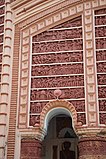 Terracotta panel at Raghunatha temple
 -
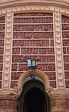 Terracotta panel at Raghunatha temple
 -
 Terracotta panel at Raghunatha temple


References
- ^ "District Statistical Handbook 2014 Purba Medinipur". Table 2.2. Department of Planning and Statistics, Government of West Bengal. Archived from the original on 21 January 2019. Retrieved 15 August 2020.
- ^ "CD block Wise Primary Census Abstract Data(PCA)". West Bengal – District-wise CD blocks. Registrar General and Census, India. Retrieved 15 August 2020.
- ISBN 978-93-81574-65-2
External links
Wikimedia Commons has media related to Alangiri.
| ||||||||||
|---|---|---|---|---|---|---|---|---|---|---|
| Cities, municipal and census towns |
|  | ||||||||
| Locations other than cities and towns |
| |||||||||
| Neighbourhoods |
| |||||||||
| Related topics | ||||||||||
This article about a location in the Purba Medinipur district of West Bengal is a stub. You can help Wikipedia by expanding it. |