
Deulghata
 Shown within West Bengal  Deulghata (India) | |
| Alternative name | Deulghat |
|---|---|
| Location | Arsha (community development block), Purulia district |
| Region | West Bengal, India |
| Coordinates | 23°22′47″N 86°07′52″E / 23.3796°N 86.1311°E |
| Type | Ancient/Medieval temples |
| History | |
| Founded | 9th/10th century |
Deulghata (also called Deulghat), near Baram in the Arsha (community development block) in the Purulia Sadar subdivision of the Purulia district of West Bengal, India, has ancient/ medieval temples.
Geography


5miles
Hills
M: municipality, CT: census town, R: rural/ urban centre, H: historical/ religious centre, F: facility
Owing to space constraints in the small map, the actual locations in a larger map may vary slightly
Location
Deulghata is located at 23°22′47″N 86°07′52″E / 23.3796°N 86.1311°E
Note: The map alongside presents some of the notable locations in the subdivision. All places marked in the map are linked in the larger full screen map.
Background
Deulghata, on the bank of the Kangsabati, some 6 km south of Jaypur and about 25 km from Purulia town once had 15 temples and some small shrines, built around the 9th-10th century. The Archaeological Survey of India has taken over the place that includes three tall surviving temples.[1]
History
In 1864–65, E.T. Dalton, Commissioner of Chhotanagpur, visited the place and found three large temples in the midst of the ruins of many more.[2] J.D. Beglar, of the Archaeological Survey of India, also reports the three temples in 1872–73.[3]
Rekha deul
Present scenario
There are three tall brick deuls with
Picture gallery
-
 Two brick deuls
 -
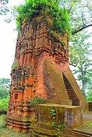 The first deul
 -
 The second deul
 -
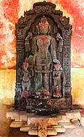 Goddess Durga
 -
 Decorated wall
 -
 Decorated wall


References
- ^ a b "District Census Handbook, Puruliya, Series 20, Part XII A" (PDF). Deulghat - Pages 99-100: Brief Description of Places of Religious, Historical or Archaeological Importance and Places of Tourist Importance of the District. Directorate of Census Operations, West Bengal. Retrieved 21 January 2020.
- ^ Notes on a Tour in Manbhoom in 1864-65, Journal of the Asiatic Society of Bengal, Volume XXXV, Part I, Page 187-189
- ^ Beglar, Joseph David, Freedone, Melik, Cunningham Alexander (1878):Report of a Tour through the Bengal Provinces|Report of a Tour Through the Bengal Provinces of Patna, Gaya, Mongir and Bhagalpur; The Santal Parganas, Manbhum, Singhbhum and Birbhum; Bankura, Raniganj, Bardwan and Hughli in 1872-73. Archaeological Survey of India.
- ISBN 978-93-81574-65-2