
Paikbheri
Paikbheri
Paik Bheri | |
|---|---|
Village | |
Bhagabanpur | |
| Website | purbamedinipur |
Paikbheri (also written as Paik Bheri) is a village in the
.Geography

5miles
M: municipal city/ town, CT: census town, R: rural/ urban centre. H: historical/ religious centre.
Owing to space constraints in the small map, the actual locations in a larger map may vary slightly
Location
Paikbheri is located at 22°06′09″N 87°43′24″E / 22.1025°N 87.7234°E.
Urbanisation
96.96% of the population of Egra subdivision live in the rural areas. Only 3.04% of the population live in the urban areas, and that is the lowest proportion of urban population amongst the four subdivisions in Purba Medinipur district.[1]
Note: The map alongside presents some of the notable locations in the subdivision. All places marked in the map are linked in the larger full screen map.
Demographics
According to the
Culture
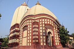
David J. McCutchion mentions the Shyama Sundara temple as a plain flat-roofed structure with pancha-ratna superstructure measuring 28’9" x 25’7" and possibly built in 1730. There is a char-chala porch measuring 19’4" sq plus 17’9" sq attached to a deul.[3]
Paikbheri picture gallery
-
 Shyma Sundara deul and flat-roofed temple
 -
 Shyama Sundara deul with char-chala porch in front
 -
 Shyama Sundara flat-roofed temple with pancha-ratna


References
- ^ "District Statistical Handbook 2014 Purba Medinipur". Table 2.2. Department of Planning and Statistics, Government of West Bengal. Retrieved 12 August 2020.
- ^ "CD block Wise Primary Census Abstract Data(PCA)". West Bengal – District-wise CD blocks. Registrar General and Census, India. Retrieved 12 August 2020.
- ISBN 978-93-81574-65-2
External links
| ||||||||||
|---|---|---|---|---|---|---|---|---|---|---|
| Cities, municipal and census towns |
|  | ||||||||
| Locations other than cities and towns |
| |||||||||
| Neighbourhoods |
| |||||||||
| Related topics | ||||||||||