
Atholville, New Brunswick
Atholville | ||
|---|---|---|
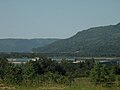
 View of Sugarloaf from Atholville | ||
|
Postal code(s) E3N
| ||
506 | ||
| Access Routes | ||
| Median Income* | $54,128 CDN | |
| Website | www.atholville.ca | |
| ||
Atholville is a community in Restigouche County, New Brunswick, Canada.[3] It held village status prior to 2023 but is now part of the city of Campbellton.
The first inhabitants of the area were the
History
Prehistory

Covered with ice during the
The village Tjikog has been permanently inhabited since at least the 6th century BC. by the
The French period
In July 1534 Jacques Cartier entered Chaleur Bay up to the mouth of the Restigouche River.[9] The French founded Acadia in 1604. Father Sebastian, a Recollect, was the first missionary to visit Tjikog in 1619 and he found a cross planted in front of a "hut of prayer".[10] The Capuchins replaced the Recollects in 1624 and the Jesuits followed in the same year then the Recollects returned in 1661.[11] The efforts of missionaries were initially focused on Cape Breton Island - where the capital of the Mi'kmaq was - then moved to Tjikog, which was regarded as the centre of Saint Anne worship in Mi'kmaq and Acadia.[8] In 1642 Father André Richard lived in the village for six months.[12] Chief Nepsuget was baptised in 1644 then 40 others in 1647.[10] Increasingly frequent contacts with Europeans allowed the Mi'kmaqs to acquire things, especially those made from metal, in exchange for furs.[13] However, diseases brought in by Europeans decimated much of the population from the 17th century.[13]
Gespegeoag was first claimed by the
The Denys family did not meet the conditions of their concession and it became crown land.
.jpg)
The Acadians settled in Pointe-aux-Sauvages on the present site of
Under British rule until the constitution
After the French and Indian War British traders established pickling plants for salmon.[5] Meanwhile, George Walker, from Bathurst, established a branch of his business in Walker Creek in 1768, on the site of Campbellton.[18] Hugh Baillie obtained the first concession which he sold to Englishman John Shoolbred.[18] Colonization was not, however, a priority and Shoolbred, not having built a school or street, lost his concession to an employee.[18]
The
Robert Ferguson was granted the concession for the territory in 1850.[12] A school was opened at that time on Roseberry Street in Campbellton which served Atholville. This building sparked the development of the urban area towards Atholville in the west.[18] The stocks of quality trees were exhausted in 1855 but fish canning and shingle factories opened.[18] The Intercolonial Railway passed through the village in 1876 which represented a significant economic opportunity.[5] Athol House was used as a weather station[30] but was destroyed in a fire in 1894.[31] The Shives company inaugurated the largest shingle works in the Maritime Provinces in 1901.[32] The Mowatt and WH Miller mills became operational in 1902 and 1905 respectively.[12] The first school was founded in 1905.[12] The post office was founded in 1906.[33] The church opened in 1909 - Atholville was then a mission of Campbellton.[32] The parish of Our Lady of Lourdes was set up in 1913.[34] The construction of the Fraser mill by the Restigouche Company began in 1919.[12] The plant was inaugurated in 1928[35] and became the third largest paper producer in the north of the province in 1929.[36] Atholville high school opened its doors in 1930.[12] The Daughters of Mary of the Assumption settled in 1934.[32] The credit union was founded in 1938.[37] The local improvement committee was founded in 1947.[12] A waterworks and sewer were inaugurated in 1950.[12] The Versant-Nord school was inaugurated in 1951[38] in the same year as the fire station.[12] The Brothers of the Sacred Heart settled in the village in 1956.[32] The J. C. Van Horne Bridge was inaugurated in 1961 in Campbellton which enabled faster travel to Quebec and contributed much to the economy.[18] Radio Engineering Products opened a factory around 1963.[32]
From the Constitution to the present day
On 9 November 1966 the Municipality of the County of Restigouche was dissolved[39] and Atholville was incorporated as a village.[40] The rest of Addington Parish became a local service district in 1967.[39] The municipal library opened its doors in the same year.[12] A merger of Atholville with Richardsville and Campbellton was studied in 1971.[41] but only the latter two were merged. Mayor Raymond Lagacé, who was elected in the same year, was one of the main opponents of municipal mergers.[42] The Sugarloaf Provincial Park was opened for winter sports in 1971 and officially opened the following year.[12] The province then saw a "golden age" of tourist development.[43] The Restigouche Centre, a shopping centre, was built in 1974.[12] A Community pool, offered by the Royal Canadian Legion, opened in 1975.[12] Residential development in Saint-Louis street started in 1976.[12] The Royal Canadian Legion got a new hall in 1977.[12] The Fraser factory in Atholville and the NBIP Dalhousie plant each received $30 million in 1980 for modernization works.[44] In total $170 million was invested in Atholville to convert the plant processes from bisulphate to magnesium.[45]
The Northeast Pine company, a furniture manufacturer, closed its plant in the early 1980s[46] and the municipality obtained ownership of the plant in 1987 to create an industrial mall.[46] The paper industry was in crisis in the same year and Fraser separated the Atholville mill into an independent company: Atholville Pulp. The factory achieved profit in subsequent years.[45] In 1988 the Atholville industrial park was the most used in the north of the province.[46] The Atholville Pulp plant however closed in 1991.[45] A pumping station was built in 1993.[12] The Fraser company sold the Atholville Pulp factory to Repap in 1994. Repap wanted to produce methanol but market conditions forced it to abandon its plans and to close the plant in 1996 after producing pulp for only six months.[45] Atholville Manor opened in 1998.[12] The Fils Atlantique textile spinning mill (Atlantic Yarns) opened in the industry mall in the late 1990s.[47]
Miller Brae park was inaugurated in 2000.
On 1 January 2023, Atholville became part of the city of Campbellton.[51] The community's name remains in official use.[52]
Toponymy
The village originally had the name Tjikog[5] but the spellings Tjigog[20] Jugugw, Tchigouk,[6] and Tzigog[32] also exist. Tjikog means "a place of superior men" in Mi'kmaq.
According to oral tradition in 1639 the village was renamed Listo Gotj by Chief Tonel.[6] The exact meaning of the place name is unknown although Father Pacifique de Valigny suggested the meaning "disobey your father!".[20] There are many other translations: "a river dividing like a hand", "a fun place in spring", "river of the long war", "small forest", "small tree", "theatre of the great squirrel quarrel", "good river for canoeing", "beautiful river like five fingers", "five branches", or "many branches".[20] In 1642 Barthélemy Vimont was the first to make a written record of the name Restigouche in reference to Chaleur Bay.[20] In 1672 Nicolas Denys was the first to mention the use of the name in connection with the village, in his Geographical and historical description of the coasts of North America, with the natural history of this country.[53] According to Father Pacifique the names Listuguj and Ristigouche or Restigouche[Note 6] derived from Listo Gotj.[20][6] Moreover, the toponym Restigouche applies, especially in a historical context, to all the settlements along the river.[23]
The village was called Sainte-Anne-de-Restigouche in the 17th century.[12][8] This name applied to the Listuguj Catholic mission in the early 20th century.[20]
The entrepreneur Robert Ferguson (1768-1851) arrived in the area in 1796 from Logierait near Blair Atholl in Scotland and built a house called Athol House: this was actually one of many Scottish names in the North of the county.[28] Robert Ferguson was nicknamed the "father and founder of Restigouche".[28] There is a village called Blair Athol 18 km by road south-east of Atholville,[28] while Point Ferguson in Atholville is named after him.[54]
At the beginning of the 20th century the village was known under four names at the same time: Soiot Athol, Shives Athol, Athol House, and Ferguson Manor.[55] One post office had Ferguson Manor on its door from 1916 to 1923 and another had Shives Athol from 1907 to 1931.[31] Following a petition the village was officially named Atholville in June 1922.[55] The Ferguson Manor post office was renamed Atholville in the following year.[31]
Geography
Related article: Geography of New Brunswick
Location

Atholville is located four kilometres west of downtown
Walker Creek rises in the south-east of the territory. It has a few tributaries in the area with the main one continuing east parallel to Highway 11. Walker Creek flows into the Restigouche River in Campbellton. There are also a few streams flowing directly into the Restigouche River. The site of the stockade (Booming Grounds) is a
In 2015, the province of New Brunswick issued regulations that expanded the boundaries of Atholville by annexation of the service district of St. Arthur, the local service district of Val D’Amours, a portion of the Village of Tide Head and a portion of the local service district of Blair Athol. The effective date of the order was July 1, 2015.[59] The land area of the village grew from 10.25 km2 to 119.60 km2, according to census data.[60][57]
Geology

The geological base of Atholville is composed of several rock types. North of Notre-Dame Street in the lowest area there are
Environment
The Booming Grounds on the border with Tide Head is an area coming under the Joint Plan of Eastern Habitats.[62] They are home to migratory aquatic birds and breeding grounds for birds such as the Great blue heron, the Osprey, and various mammals. In addition, up to 2,000 snow geese can be observed between mid-April and late May.[63] There are many rare plants growing here including the western waterweed, the jonc délié, and the Sanicula gregaria.[62] Fourteen species of fish have been recorded in the river, the most common being the Atlantic salmon and the Slimy sculpin.[64]
Although considered a threatened species, the
Demographics
In the 2021 Census of Population conducted by Statistics Canada, Atholville had a population of 3,290 living in 1,490 of its 1,550 total private dwellings, a change of -7.8% from its 2016 population of 3,570. With a land area of 119.58 km2 (46.17 sq mi), it had a population density of 27.5/km2 (71.3/sq mi) in 2021.[68]
| 2021 | 2016 | 2011 | |
|---|---|---|---|
| Population | 3,290 (-7.8% from 2016) | 3,570 (-5.5% from 2011) | 1,237 (-6.1% from 2006) |
| Land area | 119.58 km2 (46.17 sq mi) | 119.60 km2 (46.18 sq mi) | 10.25 km2 (3.96 sq mi) |
| Population density | 27.5/km2 (71/sq mi) | 29.8/km2 (77/sq mi) | 120.7/km2 (313/sq mi) |
| Median age | 52.8 (M: 52.0, F: 53.2) | 50.3 (M: 50.5, F: 49.9) | 49.9 (M: 49.1, F: 51.2) |
| Private dwellings | 1,550 (total) 1,490 (occupied) | 1,584 (total) | 588 (total) |
| Median household income | $62,800 | $54,128 | $43,469 |
Atholville's population is mostly Acadian but there is also a substantial anglophone minority.
Housing
According to Statistics Canada the village had 1,584 private dwellings in 2016 including 1,539 occupied by residents.[57]
Language
| Canada Census Mother Tongue - Atholville, New Brunswick[67] | ||||||||||||||||||
|---|---|---|---|---|---|---|---|---|---|---|---|---|---|---|---|---|---|---|
| Census | Total | French
|
English
|
French & English
|
Other
| |||||||||||||
| Year | Responses | Count | Trend | Pop % | Count | Trend | Pop % | Count | Trend | Pop % | Count | Trend | Pop % | |||||
2016
|
3,540
|
3,095 | 87.4% | 375 | 10.6% | 60 | 1.7% | 10 | 0.3% | |||||||||
2011
|
1,225
|
920 | 75.10% | 255 | 20.82% | 40 | 3.26% | 10 | 0.82% | |||||||||
2006
|
1,270
|
905 | 71.26% | 305 | 24.01% | 50 | 3.94% | 10 | 0.79% | |||||||||
2001
|
1,340
|
1,095 | 81.72% | 220 | 16.42% | 0 | 0.00% | 25 | 1.86% | |||||||||
1996
|
1,380
|
1,120 | n/a | 81.16% | 235 | n/a | 17.03% | 25 | n/a | 1.81% | 0 | n/a | 0.00% | |||||
Economy
Employment and income
The 2006 Census by
Nearly 1,500 people work in Atholville which is more than the total population of the village.[12]
Evolution of unemployment in Atholville

- Sources
- Profiles of communities in 1996 - Atholville - Income and Work, Statistics Canada website
- Profiles of communities in 2001 - Atholville - Work, Statistics Canada website
- Profiles of communities of 2006 - Atholville - Work, Statistics Canada website
Of those aged 15 years and over, 785 people reported profits and 1,085 reported income in 2005.[75] 86.5% also reported hours of unpaid work.[74] The median income then stood at $20,393 before tax and $18,692 after tax compared to the provincial average of $22,000 before tax and $20,063 after tax. Women earned on average $8,330 less than men after tax with an average income of $15,533.[75] On average 72.3% of income came from earnings, 21.1% from government benefits, and 6.4% from other sources.[75] 6.3% of all households were below the Poverty threshold after tax which increased to 7.8% for those under 18 years old.[75]
Among the working population, 2.3% of people worked at home, none worked outside the country, 5.3% had no fixed place of work, and 92.4% had a fixed place of work.[76] Of workers with a fixed place of work, 37.2% worked in the village, 57.9% worked elsewhere in the county, 1.7% worked in another county, and 3.3% worked in another province.[76]
Main economic sectors
1.4% of jobs were in the agricultural, fisheries and other resources sector, 4.3% were in Construction, 10.7% in manufacturing, 1.4% in wholesale, 21.4% in retail, 1.4% in finance and real estate, 17.1% in health and social services, 7.1% in education, 4.3% in trade services, and 30.0% in other services.[74]
The AV Cell Inc. factory, owned by the
The Restigouche Centre is the main commercial centre of the region.[12] The village has several other shops including three car dealerships and a grocery store.[12] Many other products and services are available in Campbellton which has, among others, financial institutions and a NB Liquor store. Enterprise Restigouche is responsible for economic development.[79]
-
 The Av Cell factory.
 -
 The Industrial Mall.
 -
 Shops on Val-d'Amour road.
 -
 The Credit Union.


Arts and culture
Architecture and monuments

The buildings in the Provincial Park were designed by architect Leon R. Kentridge, from the Marshall Macklin Monaghan Limited firm of Toronto. The coverings and roof are in Shingle with a gentle slope typical of a ski resort.[43]
A War memorial is located east of the Town Hall. The old Athol House Cemetery is the oldest in Restigouche County.[27] There is a monument to the memory of Athol House Chapel.[27] It is located in the river behind the AV Cell factory.
The ruins of the landing stage that allowed the supply of wood for the pulp and paper mill until the 1960s are still visible in to the west of the Village.[80]
Languages
According to the Official Languages Act, Atholville is bilingual
-
 An English sign photographed in 2011.
 -
 A French sign also photographed in 2011.


Culture
Atholville is briefly mentioned in several novels including Le Feu du mauvais temps (Fire in bad weather) (1989) by Claude Le Bouthillier. The village is also mentioned in the biographies: Ma's Cow: Growing Up in the Canadian Countryside During the Cold War (2006) by Patrick Flanagan, David Adams Richards of the Miramichi: A Biographical Introduction (2010) by Michael Anthony Tremblay and Tony Tremblay, and Think Good Thoughts (2010) by J.P. (Pat) Lynch.
The history, culture and geography of the region are featured at the Museum of the Restigouche River at
Attractions
The village has several community services and facilities, including Sugarloaf Provincial Park.
Sports
The village has two football fields, a skating rink, a public pool, Miller Brae Millennium Park, and the
Atholville contributes to the funding of Campbellton Civic Centre with Tide Head.[12] A trail passes through the village towards Tide Head where it joins the International Appalachian Trail. A gazebo was built at the top of the Old Mission. There are several unmarked viewing points such as that at boulevard Beauvista.
-
 The Ski resort on Sugarloaf
 -
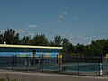 Public pool
 -
 The Alma Community Centre
 -
 Campbellton Civic Centre


Government
The former village is split among Wards 1, 2, and 3 of the city of Campbellton.
| List of successive Mayors of Atholville | |||||
|---|---|---|---|---|---|
| Party | Term | Name[12] | |||
| Independent | 1966-1971 | Léonard Doiron | |||
| Independent | 1971-2012 | Raymond Lagacé | |||
| Independent | 2012-2016 | Michel Soucy | |||
The municipality has six to eight employees on average, plus seasonal employees.[12]
Budget and taxation

The annual expenditure of Atholville village amounted to 2,936,943 dollars in 2011. Of this amount:[85]
- 18.4% was spent on administration,
- 7.5% on town planning,
- 7.2% on the police,
- 6.3% on protection against fire,
- 7.1% on the distribution of water,
- 0.2% on emergency services,
- 0.1% on other protection services,
- 22.6% on transport,
- 4.1% on sanitation,
- 0.0% on public health,
- 7.2% on management,
- 12.4% on recreation and culture,
- 12.7% on debt costs, and
- 1.7% on signage
Regional services commission
Atholville is part of Region 2,[86] a regional services commission (CSR) which officially started operations on 1 January 2013.[87] Atholville is represented on the council by the Mayor.[88] Mandatory services offered by the CSR are: regional planning, management of solid waste, emergency planning measures, and collaboration on police, planning, and cost sharing of regional infrastructure for sport, recreation and culture. Other services could be added to this list.[89]
Representation and political trends
Related articles: Politics of Canada and Politics of New Brunswick.
In
Atholville is a member of the Union of Municipalities of New Brunswick and the Francophone Association of Municipalities of New Brunswick.[12]
Education

Versant-Nord school teaches children from kindergarten to 8th year. It is a French public school within sub-district 1 of the Francophone Nord-Est School District.[38] Campbellton also has the Community College of New Brunswick (CCNB) of Campbellton which is also French language while the closest English-speaking community college is the New Brunswick Community College (NBCC) at Miramichi. The nearest francophone university campus is that of the Université de Moncton in Edmundston. Fredericton has several English language universities. A library service is also available.
For over 15 years 42.8% of the population had no certificate, diploma or degree, 22.1% had only a diploma of secondary education or equivalent, and 34.7% of them also held a certificate, diploma or a post-secondary degree. By comparison the rates were 29.4%, 26.0% and 44.6% respectively for the province.[90] In the same age group 9.0% had graduated from a short NBCC program or equivalent, 15.8% had graduated from a long program at NBCC or equivalent, 1.8% had a diploma or a university certificate below a bachelor's degree, and 8.1% had a certificate, diploma or higher degree.[90] From the graduates, 6.4% were trained in education, 2.6% in humanities, 3.8% in social sciences or law, 29.5% in commerce, management or administration, 2.6% science and technology, 15.4% in architecture, engineering or related areas, 2.6% in agriculture, natural resources and conservation, 28.2% in health, parks, recreation and fitness, and 10.3% in personal services, protection or transportation. There were no graduates in arts or communications, mathematics or computer science, nor in areas classified as "other".[90] Post-secondary graduates completed their studies outside the country in 5.1% of cases.[90]
Infrastructure

Atholville,
Campbellton has the French-speaking Restigouche Hospital Centre and the English-speaking Campbellton Regional Hospital. New Brunswick hospitals are bilingual overall but unilingual in their jurisdictions. Campbellton also has an Ambulance New Brunswick station.
The village is connected to the NB Power network and also has an industrial-sized generator at the Town Hall.[12] Atholville has a water and sewerage network with a sewerage treatment plant.[12] The village of Val-d'Amour is connected to the Atholville water system.[12] Atholville also has an agreement with Campbellton and Tide Head for water supply.[12]
Many publications are available but French-speakers have primarily the daily
Atholville has a post office. The population also has access to the cell phone network and high-speed internet. The main provider is Bell Aliant. The nearest offices of Service New Brunswick and Service Canada are in Campbellton.
Religion

Notre-Dame-de-Lourdes is a Roman Catholic church which is part of the
Notable people
- Lewis Charles Ayles (1927-), lawyer and politician, born in Atholville;
- Edmond Blanchard (1954-), politician, born in Atholville;
- Joseph Claude (died in 1796), Chief of Listuguj;
- Robert Ferguson (Logierait (Scotland) 1768 - Campbellton 1851), businessman, justice, judge, official and militia officer;
- Bobby Hachey (1932-2006), artist, born in Atholville;
- Samuel Lee (Concord (Massachusetts) 1756 - Shediac 1805), official, judge, businessman and politician.
See also
Bibliography
- Irene Doyle, Atholville Photo Album, Campbellton, Irene Doyle, 2006 (in French and English)
- Étienne Fallu, The Credit Union at Atholville: 1938-1988, Atholville, 1988 (in French)
- Hélène Desrosiers-Godin, The marvelous Mount Sugarloaf: collection of anecdotes and historical facts, Atholville, Anne Gauvin, 2006, 23 p. (ISBN 2980846600) (in French)
Notes and references
Notes
- Tide Head, 7 kilometres west of Atholville.
- ^ Tonel means "thunder".
- Québec.
- Tide Head to the west and Belleduneto the east.
- ^ In New Brunswick, a parish is a territorial sub-division which lost administrative significance in 1966 but has always been used for census purposes.
- ^ The spelling Ristigouche is more common in French while Restigouche is official in English. Listuguj is the modern Mi'kmaq name.
References
- ^ "Atholville". Government of New Brunswick. Archived from the original on June 11, 2011.
- ^ "Census Profile for Atholville". Statistics Canada. 6 December 2022. Retrieved 11 January 2023.
- ^ "Atholville". New Brunswick Provincial Archives.
- ^ a b General geological map of shallow sediments in New Brunswick, AA. Seaman, 2002, Ministry of Natural Resources and Energy, consulted on 7 August 2009 (in French)
- ^ , consulted on 7 August 2009 (in French)
- ^ a b c d e f g h i The Micmacs at the Athol house Site, Restigouche Gallery website, consulted on 21 August 2012
- ^ a b c Philip K. Bock and William C. Sturtevant, Handbook of North American Indians, 13 Volumes, Vol. 1, Government Printing Office, 1978, pp. 109-110, 777 pages
- ^ ISBN 978-2-7637-9323-8(in French)
- ^ Ristigouche River, Toponymy Commission of Québec, consulted on 29 November 2012 (in French)
- ^ a b Canadian Historical society of the Catholic church, Study Sessions, Société canadienne d'histoire de l'Église catholique, 1978, p. 88 (in French).
- ^ a b c d e f g h i j k The French at the Athol house Site Archived 2016-03-03 at the Wayback Machine, Restigouche Gallery website, consulted on 21 August 2012
- ^ a b c d e f g h i j k l m n o p q r s t u v w x y z aa ab ac ad ae af ag ah ai aj ak al A self-sufficient municipality...and more too Archived 2015-09-23 at the Wayback Machine, consulted on 8 December 2011 (in French)
- ^ a b Bock and Sturtevant (1978), opcit, p. 117.
- ^ Denys, Nicolas, George MacBeath, 2000, Online biographical dictionary of Canada website, University of Toronto, consulted on 21 August 2012
- ^ a b c d Denys, Richard, George MacBeath, 2000, Online biographical dictionary of Canada, University of Toronto, consulted on 21 August 2012
- ^ Le Clercq, Chrestien, G.-M. Dumas, 2000, Online biographical dictionary of Canada, University of Toronto, consulted on 21 August 2012
- ^ William Gagnong, A Monograph of historic sites in the province of New Brunswick, J. Hope, Ottawa, 1899, p. 300, Read online, consulted on 15 August 2012
- ^ a b c d e f g h i j Visitor Guide and maps, Campbellton website, consulted on 20 August 2012
- ^ a b Ganong (1899), opcit, p. 344.
- ^ a b c d e f g Listuguj, Toponymy Commission of Québec, consulted on 29 November 2012 (in French).
- ^ a b Department of Indian and Northern Affairs, Tawow, Volumes 1 to 6, Ottawa, 1970, p. 41
- ISBN 978-2-7621-2613-6(in French)
- ^ a b c William Gagnong, A Monograph of the Origins of the Settlements in New Brunswick, J. Hope, Ottawa, 1904, 185 pages, p. 168-169
- ^ a b c W.J. Eccles, Battle of Restigouche, The Canadian Encyclopedia.
- ^ Laval University, consulted on 29 NOvember 2012.
- ISBN 9781554882090
- ^ a b c Notre-Dame de Lourdes parish, Irene Doyle, 1998, Irene's genealogy and history website, consulted on 20 August 2012
- ^ a b c d William Baillie Hamilton, Place Names of Atlantic Canada, University of Toronto Press, Toronto, 1996, 502 pages, p. 45
- ^ a b Genealogical guide to the county of Restigouche, 2006, Archives provinciales du Nouveau-Brunswick website, consulted on 24 November 2012 (in French)
- ISBN 9780415028110.
- ^ a b c Alan Rayburn, Geographical Names of New Brunswick, Energy, Mines, and Resources Canada, Ottawa, 1975, p. 40
- ^ a b c d e f Margerite Michaud, The Acadians of the Maritime provinces, historical and tourist guide, Imprimerie acadienne, Moncton, 1968, 165 pages, p. 61 (in French).
- ^ Place names of New Brunswick - Atholville, Provincial Archives of New Brunswick, consulted on 1 November 2011 (in French).
- ^ a b Notre-Dame de Lourdes parish Archived July 14, 2014, at the Wayback Machine, Diocese of Bathurst, consulted on 20 August 2012
- ^ Nicolas Landry and Nicole Lang, History of Acadia, Éditions du Septentrion, Québec, 2001, p. 259 (in French).
- ISBN 2760504808(in French)
- ^ Étienne Fallu, The Credit Union of Atholville, 1938-1988, Atholville, 1988 (in French)
- ^ a b Francophone North-East, Ministry of Education of New Brunswick], consulted on 2 November 2012 (in French)
- ^ (in French)
- ^ Quadrennial municipal elections Archived December 25, 2013, at the Wayback Machine, 14 May 2012, Report of the Director-general on the municipal elections, Read online Archived December 26, 2013, at the Wayback Machine, consulted on 24 December 2013
- ^ New Brunswick. Dept. of Municipal Affairs, Ministry of the Environment and local government, Amalgamation Study For Campbellton, Atholville, and Richardsville, Fredericton, 1971, 35 pages.
- ^ a b Jean-François Boisvert, The doyen of municipal politics demands respect, L'Acadie Nouvelle, 4 April 2012 (in French)
- ^ ISBN 978-0-86492-504-6.
- ^ Savoie and Baudin (1988), opcit, p. 160.
- ^ a b c d Graeme Rodden, Atholville Receives a New Lease on Life as Av Cell, Pulp & Paper Canada, 1 April 1999, Read online Archived 2013-12-24 at the Wayback Machine, consulted on 23 August 2012.
- ^ a b c Savoie and Baudin (1988), opcit, p. 96.
- ^ a b c Radio-Canada, The future does not have yarn, 15 January 2009, Radio-Canada News, See online, consulted on 27 November 2012 (in French).
- ^ Restigouche Credit Union Archived August 12, 2012, at the Wayback Machine, Acadian Credit Unions website, consulted on 30 December 2010.
- ^ Radio-Canada, Roland-Pépin school resumes life, 26 January 2012, Radio-Canada News, See online, consulted on 23 February 2012 (in French)
- ^ Jean-François Boisvert, Marijuana: Zenabis chooses Atholville, L'Acadie Nouvelle, 11 March 2014, Read online (in French)
- ^ "Local Governments Establishment Regulation – Local Governance Act". Government of New Brunswick. 30 August 2022. Retrieved 29 November 2022.
- ^ "Proposed entity names reflect strong ties to nature and history" (Press release). Irishtown, New Brunswick: Government of New Brunswick. 25 May 2022. Retrieved 20 January 2023.
- ^ Original name: Description géographique et historique des côtes de l'Amérique septentrionale, avec l'histoire naturelle de ce pays, (in French)
- ^ Hamilton (1996), opcit, p. 74.
- ^ a b L'Évangéline, 15 June 1922, 5 pages, (in French)
- ISBN 2921166062, Demography and demo-linguistics in Acadia, 1871-1991, p. 141 (in French)
- ^ a b c d "Census Profile, 2016 Census: Atholville, Village [Census subdivision], New Brunswick". Statistics Canada. Retrieved September 28, 2019.
- ISBN 9781558496675.
- ^ "Municipalities Order, NB Reg 85-6". CanLII. Government of New Brunswick. Retrieved September 28, 2019. Section 34, "Village of Atholville"
- ^ a b "2011 Census Profile: Atholville, NB". Statistics Canada. Retrieved September 28, 2019.
- ^ a b c d Bedrock Geology of New Brunswick, New Brunswick government, consulted on August 19, 2012 (in French)
- ^ a b c Zelazny (2007), opcit, p. 143-144.
- ISBN 978-0-88780-674-2
- ^ "Restigouche River, Hydrographic Basins of New Brunswick" (PDF). Ministry of Environment and Local government. Archived from the original (PDF) on July 14, 2014., New-Brunswick government, online 2007, consulted on 29 November 2012 (in French).
- ^ Ash from the paper mill causes discontent in Atholville, Radio-Canada News, October 17, 2012, consulted on November 27, 2012 (in French).
- ^ The public are not reassured, Radio-Canada News, July 20, 2007, consulted on November 27, 2012 (in French).
- ^ 2011census
- ^ a b "Population and dwelling counts: Canada, provinces and territories, census divisions and census subdivisions (municipalities), New Brunswick". Statistics Canada. February 9, 2022. Retrieved February 21, 2022.
- 2021 Canadian Census. Statistics Canada. February 4, 2022. Retrieved 2023-10-19.
- 2016 Canadian Census. Statistics Canada. August 12, 2021. Retrieved 2019-09-28.
- 2011 Canadian Census. Statistics Canada. March 21, 2019. Retrieved 2014-03-28.
- 2006 Canadian Census. Statistics Canada. August 20, 2019.
- 2001 Canadian Census. Statistics Canada. July 18, 2021.
- ^ a b c Profiles of communities of 2006 - Atholville - Work, Statistics Canada website, consulted on 20 November 2012.
- ^ a b c d Profiles of communities in 2006 - Atholville - Income and profits, Statistics Canada website, consulted on 20 November 2012.
- ^ a b Profiles of communities in 2006 - Atholville - Place of work, Statistics Canada website, consulted on 20 November 2012.
- ^ AV Cell Inc. Archived 2014-07-15 at the Wayback Machine, AV Group website, consulted on 15 June 2014.
- ^ Renovations in the industrial mall in Atholville, New Brunswick government website, consulted on 9 November 2011
- ^ Regional services district 2 Archived March 3, 2016, at the Wayback Machine, Foundation of local governments and viable regions (Finn Report)], on the New Brunswick government website, consulted on 25 July 2011.
- ISBN 9780760331194
- ^ Law on Official languages (New Brunswick), 7 June 2002, Articles 35, 36, 37, and 38, Read online Archived January 8, 2012, at the Wayback Machine, consulted on 15 March 2011.
- ^ Jean-François Boisvert, Bilingual Signage Obligatory, L'Acadie Nouvelle, 15 March 2011, consulted on 5 March 2011 (in French)
- ^ a b Things to do in Summer Archived July 14, 2014, at the Wayback Machine, Sugarloaf Park website, consulted on 27 November 2012.
- ^ Things to do in Winter Archived July 14, 2014, at the Wayback Machine, Sugarloaf Park website, consulted on 27 November 2012.
- ^ Annual report on municipal statistics for New Brunswick - 2012, Fredericton, 2012, Read online.
- ^ The communities in each of 12 Regional Services Commissions (CSR), New Brunswick government website, consulted on 9 November 2012.
- ^ Administration councils for Regional Services Commissions announcements, New Brunswick government, consulted on 1 November 2012.
- ^ Governance of new Regional Services Commissions, New Brunswick government, consulted on 9 November 2012.
- ^ Obligatory services, New Brunswick government website, consulted on 9 November 2012.
- ^ a b c d Profiles of communities in 2006 - Atholville - Education, Statistics Canada website, consulted on 20 November 2012.
External links
Places adjacent to Atholville, New Brunswick | ||||||||||||||||
|---|---|---|---|---|---|---|---|---|---|---|---|---|---|---|---|---|
| ||||||||||||||||
Subdivisions of New Brunswick | |
|---|---|
| Cities | |
Towns |
|
Villages | |
| Regional municipality | |
Rural communities | |
| Rural districts |
|
| Other administrative divisions | |