
Blue Ridge Parkway
Blue Ridge Parkway | |
|---|---|
 Blue Ridge Parkway route map | |
| Route information | |
| Maintained by National Park Service | |
| Length | 469 mi[1] (755 km) |
| Existed | June 30, 1936–present |
| Tourist routes | |
| Restrictions | No commercial vehicles |
| Major junctions | |
| North end | |
| |
| South end | |
| Location | |
| Country | United States |
| States | Virginia, North Carolina |
| Highway system | |
IUCN category V (protected landscape/seascape) | |
 Ice Rock Milepost 242 | |
| Location | North Carolina & Virginia, USA |
| Nearest city | Asheville, NC & Roanoke, VA |
| Coordinates | 36°31′07″N 80°56′09″W / 36.51861°N 80.93583°W |
| Area | 93,390 acres (377.9 km2) |
| Established | June 30, 1936 |
| Visitors | 16,757,635 (in 2023)[2] |
| Governing body | National Park Service |
| Website | Blue Ridge Parkway |

The Blue Ridge Parkway is a National Parkway and All-American Road in the United States, noted for its scenic beauty. The parkway, which is the longest linear park in the U.S.,[3] runs for 469 miles (755 km) through 29 counties in Virginia and North Carolina, linking Shenandoah National Park to Great Smoky Mountains National Park. It runs mostly along the spine of the Blue Ridge, a major mountain chain that is part of the Appalachian Mountains. Its southern terminus is at U.S. Route 441 (US 441) on the boundary between Great Smoky Mountains National Park and the Qualla Boundary of the Eastern Band of Cherokee Indians in North Carolina, from which it travels north to Shenandoah National Park in Virginia. The roadway continues through Shenandoah as Skyline Drive, a similar scenic road which is managed by a different National Park Service unit. Both Skyline Drive and the Virginia portion of the Blue Ridge Parkway are part of Virginia State Route 48 (SR 48), though this designation is not signed.
The parkway has been the most visited unit of the National Park System every year since 1946 except four (1949, 2013, 2016 and 2019).[4][5] Land on either side of the road is owned and maintained by the National Park Service, and in many places parkway land is bordered by United States Forest Service property. There is no fee for using the parkway; however, commercial vehicles are prohibited without approval from the Park Service Headquarters, near Asheville, North Carolina.[6][7] The roadway is not maintained in the winter, and sections that pass over especially high elevations and through tunnels are often impassable and therefore closed from late fall through early spring. Weather is extremely variable in the mountains, so conditions and closures often change rapidly. The speed limit is never higher than 45 mph (72 km/h) and is lower in some sections.
In addition to the road, the parkway has a folk art center located at mile marker 382 and a visitor center located at mile marker 384, both near Asheville. There are also numerous parking areas at trailheads for the various hiking trails that intersect the parkway, and several campgrounds located along the parkway allow for overnight stays. The Blue Ridge Music Center (also part of the park) is located in Galax, and Mount Mitchell (the highest point in eastern North America) is only accessible via North Carolina Highway 128 (NC 128), which intersects the parkway at milepost 355.4.[8]
Route description


The parkway runs from the southern terminus of
The parkway uses short side roads to connect to other highways, and there are no direct interchanges with
Cold weather
Much of the parkway is located at high elevation, with colder, wetter and windier conditions than in surrounding areas.[9] The highest point on the parkway (south of Waynesville, near Mount Pisgah in North Carolina) is 6,053 feet (1,845 m) above sea level on Richland Balsam at milepost 431.[10] Sections of the parkway may be temporarily closed to repair damage caused by the cold winter climate of the mountains or for other maintenance.[9] The parkway's natural resource protection protocol limits the use of ice melting chemicals, and certain areas could remain closed for extended periods.[11] During road closures alternative routes are used, but short-term closures may not have a signed detour route.[12] Sections of the parkway near the tunnels are often closed in winter due to icy conditions.[13]
Highlights in Virginia


- Mile 0 Rockfish Gap near Waynesboro, Virginia, is the northern end of the Blue Ridge Parkway. To the north the parkway connects directly to Skyline Drive, which winds 105 miles (169 km) through Shenandoah National Park.
- 5 to 9.3 hiking trailfrom the parking area (at mile 6.1) leads 0.75 miles (1.21 km) to The Rocks, whose humped appearance gives the area its name. Greenstone self-guiding trail (8.8).
- 10.7 Ravens Roost offers vistas of Torry Mountain and the Shenandoah Valley to the west. The overlook is built above a cliff, so it is frequently used for rock climbing and hang gliding. There is also a single picnic table.
- 16 Sherando Lake is a recreation area in picnicking, and camping.
- 29 Whetstone Ridge provided many a mountain man with a fine-grained sharpening stone.
- 34.4 Yankee Horse Ridge supposedly is where a hard-riding logging railroadprovides access to Wigwam Falls.
- 58 to 63.6 Otter Creek runs 10 miles (16 km) down the Blue Ridge to the James River. Otter Lake (63.1), fishing, trail.
- 63.8 The canal locksand exhibits. A self-guiding trail follows the river bluff.
- 71 Onion Mountain's short loop trail leads through rhododendron and mountain laurel.
- 83.4 Fallingwater Cascades can be seen along a 1.6-mile (2.6 km) loop trail.
- 84 to 87 Peaks of Otter are three mountain peaks which have been popular viewing sites since the days of Thomas Jefferson. A shuttle bus provides service to Sharp Top.
- 114.9 The Roanoke River Gorge is visible after a short walk.
- 120.4 Roanoke Mountain is a 3.7-mile (6.0 km) side trip. A one-way loop road, with steep grades, crosses over the mountain. Towed vehicles are prohibited.
- 129.6 Roanoke Valley Overlook gives a view of the largest city along the parkway.
- 154.5 Smart View is named for having "a right smart view". A nearby cabin built in the 1890s is known as a spot for viewing dogwoodblooms in early May.
- 167 to 174 Rocky Knob Recreation Area overlooks Rock Castle Gorge.
- 176.1 Mabry Mill was operated by E.B. Mabry from 1910 to 1935. A trail leads to his gristmill, sawmill, blacksmith shop, and other exhibits. Old-time skills are demonstrated in the summer and fall.
- 188.8 Groundhog Mountain has a variety of rural fences: snake, Post-and-rail, picket and buck. Picnic grounds and observation tower are also nearby.
- 189.1 Groundhog Mountain
- 189.9 Aunt Orelena Puckett Cabin Exhibit was the home of an area midwife.
Highlights in North Carolina
.jpg)


The Blue Ridge Parkway crosses the North Carolina–Virginia state line at mile 216.9. The 1749 party that surveyed the boundary included Peter Jefferson, father of Thomas Jefferson.

- Mile 217.5 Cumberland Knob, at 2,885 feet (879 m), is the centerpiece of a small parkway recreation area.
- 218.6 Fox Hunters Paradise, down a short walking path, is where hunters could listen to their hounds baying in the valley below.
- 238.5 Brinegar Cabin was built by Martin Brinegar about 1880 and lived in until the 1930s when the homestead was purchased from his widow for the parkway. The original cabin stands there today.
- 238.5 to 244.7 campground.
- 258.6 Northwest Trading Post offers crafts from North Carolina's northwestern counties.
- 260.6 Jumpinoff Rock is at the end of a short woodland trail.
- 264.4 The Lump is a grassy knob that provides views of the forested foothills.
- 272 E. B. Jeffress Park has a self-guided trail to a waterfall known as the Cascades. Another trail goes to an old cabin and church.
- 285.1 Daniel Boone's Trace, which Boone blazed to the West, crosses near here.
- 292 to 295 Flat Top Manor, the former house of Moses H. Cone, is now used as the Parkway Craft Center.
- 295.1 to 298 Julian Price Memorial Park, the former retreat of the insurance executive Julian Price, offers a variety of hiking trails, campground, and 47-acre (190,000 m2) Price Lake. This is the only lake on the parkway on which paddling is allowed.
- 304.4 Linn Cove Viaduct, the last segment of the parkway built, skirts the side of Grandfather Mountain. A visitor center is located nearby and provides access to a trail under the viaduct.
- 308.3 Flat Rock provides views of Grandfather Mountain and Linville Valley.
- 316.3 Linville Falls Recreation Area provides trails with overlooks of Linville Falls and the Linville Gorge. A campground and picnic area are also provided.
- 331 The Museum of North Carolina Minerals interprets the state's mineral wealth.
- 339.5 Crabtree Meadows & Crabtree Falls is a parkway recreation area with a picnic area, campground, giftshop and hiking trails.
- 349.2 Laurel Knob provides views of Grandfather Mountain, Linville Mountain, Hawksbill Mountain, and Table Rock.
- 355.4 Mount Mitchell State Park, reached via NC 128, is the highest point east of the Mississippi River.
- 359.8 Walker Knob, formerly known as Balsam Gap, is located where the Black Mountains and the Great Craggy Mountains meet.
- 361.2 Glassmine Falls is an 800-foot (240 m) ephemeral waterfall visible from an overlook on the side of the parkway.
- 363.4 to 369.6 Craggy Gardens in the Great Craggy Mountains are covered with purple rhododendron in mid-to-late June. Craggy Pinnacle Trail and other trails (364.1 and 364.6); road to picnic area and trails (367.6).
- 382 The Folk Art Center is the flagship facility of the Southern Highland Craft Guild. It offers sales and exhibits of traditional and contemporary crafts of the Appalachian region. There are interpretive programs, three galleries, a library and a book store.
- 384 The Blue Ridge Parkway Visitor Center is the newest along the parkway.[14] Exhibits focus on the history and heritage of the parkway and western North Carolina.
- 408.6 Mount Pisgah was part of the Biltmore Estate. The estate became home of the first forestry school in America and the nucleus of the Pisgah National Forest. Also located here is the Pisgah Inn resort, a park service concession.
- 417 Looking Glass Rock is visible from many spots on the parkway starting at Mount Pisgah.
- 418 East Fork Overlook. Located here are the headwaters of the Pigeon River. Yellowstone Falls is a short distance away and gets its name from the yellowish moss covering the rocks.
- 420.2 Shining Rock Wilderness is the largest wilderness area in North Carolina, covering 18,483 acres (74.80 km2), with 25 miles (40 km) of trails and peaks over 6,000 ft (1,800 m). The wilderness is named for Shining Rock.
- 420.2 Black Balsam Knob is a grassy bald with panoramic views just outside the Shining Rock Wilderness in Pisgah National Forest. The wilderness area also includes Cold Mountain.
- 422.4 Devil's Courthouse is a rugged exposed mountaintop rich in Cherokee traditions.
- 423.5 Herrin Knob Overlook. A hiking trail goes around Tanasee Bald and Herrin Knob. Tanasee Bald (423.7) is said to be the home of the mythical Cherokee giant Tsul 'Kalu.
- 431 Richland Balsam is the highest point on the parkway at 6,053 feet (1,845 m). There is a self-guiding trail that passes through a remnant spruce-fir forest.
- 435.7 Licklog Ridge once hosted cattlemen and their herds of cattle before it became part of the national forest. The area earns its name from the cattlemen who would place rocks of salt into logs and holes in the earth.
- 451.2 Waterrock Knob provides a panorama of the Great Smokies, visitor center, trail, comfort station, exhibits.
- 458.2 Heintooga Ridge Road runs north from the parkway 8.8 miles (14.2 km) to Heintooga Overlook in Great Smoky Mountains National Park.
- Mile 469 The southern end of the Blue Ridge Parkway intersects with U.S. 441 in Great Smoky Mountains National Park near Cherokee, North Carolina.
History

Begun during the administration of President Franklin D. Roosevelt, the project was originally called the Appalachian Scenic Highway.
Original plans called for the parkway to connect Shenandoah National Park and Great Smoky Mountains National Park with the parkway either turning west into Tennessee at
Most construction was carried out by private contractors under federal contracts under an authorization by Ickes in his role as federal public works administrator. Work began on September 11, 1935, near Cumberland Knob in
The parkway's construction created jobs in the region, but also displaced many residents and created new rules and regulations for landowners, including requirements related to how farmers could transport crops.[18] Residents could no longer build on their lands without permission, or develop land except for agricultural use.[18] They were not permitted to use the parkway for any commercial travel but were required to transport equipment and materials on side roads.[18]
The
Construction of the parkway was complete by the end of 1966 with one notable exception.[20] The 7.7-mile (12.4 km) stretch including the Linn Cove Viaduct around Grandfather Mountain did not open until 1987.[21] The project took over 52 years to complete.
Due to serious damage in 2004 from Hurricane Frances, then again by Hurricane Ivan, many areas along the parkway were closed until the spring of 2005, with two areas that were not fully repaired until the spring of 2006.
The parkway was on North Carolina's version of the
Proposed extension
An extension of the parkway from its terminus at Beech Gap, North Carolina to a point north of
Ecology
Flowering
Major trees include
The Blue Ridge Parkway has also been a corridor for the spread of many invasive species, including
Major intersections
| Commonwealth/State | County[30] | Location | mi[31] | km | Destinations | Notes |
|---|---|---|---|---|---|---|
One-quadrant interchange plus connector road; northern terminus of parkway; I-64 exit 99 | ||||||
SR 664 (Beech Grove Road / Reeds Gap Road) – Waynesboro | ||||||
| Nelson | | 16.0 | 25.7 | Unpaved road | ||
| | 16.1 | 25.9 | ||||
Steele's Tavern | One-quadrant interchange | |||||
| Rockbridge | Humphreys Gap | 45.5 | 73.2 | One-quadrant interchange | ||
| Amherst | Otter Creek | 61.3 | 98.7 | One-quadrant interchange | ||
US 501 – Big Island, Glasgow | One-quadrant interchange | |||||
| Peaks of Otter | 85.9 | 138.2 | North end of SR 43 overlap; north end of VDOT maintenance of SR 43 (southern segment) | |||
| Botetourt | Powell Gap | 89.0 | 143.2 | |||
Two-quadrant interchange ; south end of SR 43 overlap; south end of VDOT maintenance of SR 43 (northern segment) | ||||||
| | 105.9 | 170.4 | Two-quadrant interchange | |||
| Roanoke | | 112.3 | 180.7 | Two-quadrant interchange | ||
| | 115.2 | 185.4 | Virginia's Explore Park (Roanoke River Parkway ) | |||
| | 120.5 | 193.9 | Downtown Roanoke (Mill Mountain Parkway ) | |||
| | 121.4 | 195.4 | Two-quadrant interchange | |||
| Adney Gap | 136.0 | 218.9 | Connector road | |||
SR 109 | ||||||
| Tuggle Gap | 165.1 | 265.7 | One-quadrant interchange | |||
| | 174.0 | 280.0 | SR 102 north | |||
| | 174.1 | 280.2 | SR 102 south | |||
| | 174.2 | 280.3 | ||||
US 58 Bus.) – Stuart, Hillsville | Parkway and US 58 grade-separated; two-quadrant interchange with US 58 Bus. | |||||
| Patrick–Carroll county line | Willis Gap | 192.1 | 309.2 | |||
SR 608 (Lightning Ridge Road) | ||||||
| | 199.2 | 320.6 | SR 608 (Ranger Road) | |||
Mt. Airy, Hillsville | Two-quadrant interchange | |||||
Mt. Airy, Galax | One-quadrant interchange | |||||
Mt. Airy | One-quadrant interchange | |||||
| | 229.6 | 369.5 | US 21 – Roaring Gap, Sparta | Two-quadrant interchange | ||
| | 248.0 | 399.1 | One-quadrant interchange | |||
| Ashe | Miller Gap | 258.7 | 416.3 | Trading Post Road – Glendale Springs | ||
| Horse Gap | 261.2 | 420.4 | Two-quadrant interchange | |||
Deep Gap | 276.5 | 445.0 | One-quadrant interchange | |||
| | 280.9 | 452.1 | Old US 421 | Connector road | ||
| | 290.8 | 468.0 | Green Hill Road | |||
| | 291.9 | 469.8 | Two-quadrant interchange | |||
| Avery | | 294.6 | 474.1 | One-quadrant interchange | ||
| | 312.1 | 502.3 | One-quadrant interchange | |||
| | 316.4 | 509.2 | Linville Falls Road – Linville Falls | |||
| | 317.5 | 511.0 | One-quadrant interchange | |||
| Mitchell | Gillespie Gap | 330.8 | 532.4 | One-quadrant interchange | ||
| | 333.9 | 537.4 | One-quadrant interchange/connector road hybrid | |||
| Yancey | Buck Creek Gap | 344.1 | 553.8 | One-quadrant interchange | ||
| Black Mountain Gap | 355.4 | 572.0 | ||||
Vance Birthplace | ||||||
| Craven Gap | 377.4 | 607.4 | ||||
| Asheville | 382.6 | 615.7 | Two-quadrant interchange | |||
| | 384.8 | 619.3 | Two-quadrant interchange | |||
| | 388.8 | 625.7 | NC Arboretum | Two-quadrant interchange | ||
| | 393.6 | 633.4 | One-quadrant interchange | |||
| Henderson | Elk Pasture Gap | 405.6 | 652.7 | |||
| Haywood | Wagon Road Gap | 411.8 | 662.7 | One-quadrant interchange | ||
| Transylvania | Beech Gap | 423.3 | 681.2 | One-quadrant interchange | ||
| Haywood | Balsam Gap | 443.5 | 713.7 | One-quadrant interchange | ||
| Soco Gap | 455.7 | 733.4 | Two-quadrant interchange | |||
| Jackson | Wolf Laurel Gap | 458.2 | 737.4 | Balsam Mountain, Black Camp Gap, Masonic Marker (Heintooga Ridge Road) | ||
| Swain | Ravensford | 469.1 | 754.9 | Southern terminus of parkway | ||
1.000 mi = 1.609 km; 1.000 km = 0.621 mi
| ||||||
Tunnels
 Bluff Mountain Tunnel | |
| Overview | |
|---|---|
| Location | Blue Ridge Parkway |
| Route | Blue Ridge Parkway |
| Operation | |
| Work begun | 1930s |
| Constructed | stone and concrete |
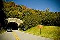
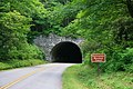
There are 26 tunnels constructed along the Blue Ridge Parkway. One, the Bluff Mountain Tunnel,[32] is in Virginia and twenty-five are in North Carolina.[33]
The design standards specified a minimum impact on the land. The vehicle tunnels were often constructed to reduce excessive landscape scarring that open cuts would have produced. They are used in areas of steep terrain where ridges run perpendicular to the roadway alignment.
North Carolina's more rugged terrain required the majority of the tunnels. Most of the work on the tunnel digging was done by hand and provided by the Civilian Conservation Corps in the 1930s.[34] Little machinery was used with the intention of creating manual labor in depressed economic times. They did have for tunneling truck-mounted water-cooled compressed air drills called "Jumbos." After the initial holes were drilled into the substrata, dynamite was used for blasting away the rock.[35]
Concrete lining was done during construction due to tunnel cave-ins.[36] This concrete lining was first used in the Devil's Courthouse Tunnel. It was later discovered that it enhanced the interior lighting within the tunnel itself. Where done the lining covered about a quarter of the interior structure. An additional benefit was the elimination of moisture entering the tunnel. Moisture in the winter caused ice problems.[37]
The Pine Mountain Tunnel is the longest on the parkway at 1,434 feet (437 m). Ferrin Knob Tunnel #1 is the first and longest of the triplet tunnels. The local people once referred to ferns as "ferrins." Ferrin Knob Tunnel #2 is located at milepost 401.3 and Ferrin Knob Tunnel #3 is located at milepost 401.5.
The distinctive stone masonry portals now on the parkway tunnels were generally not part of the original construction of the 1930s. They were added later.[38]
The tunnels are listed below by
| Milepost | Name of the tunnel | Length | Maximum Height | Minimum Height | Coordinates |
|---|---|---|---|---|---|
| 53.1 | Bluff Mountain Tunnel | 630 feet (192 m) | 19 feet 1 inch (5.8 m) | 13 feet 7 inches (4.1 m) | 37°39′55″N 79°19′22″W / 37.66538°N 79.322866°W |
| 333.4 | Little Switzerland Tunnel | 542 feet (165 m) | 19 feet 8 inches (6.0 m) | 14 feet 4 inches (4.4 m) | 35°51′06″N 82°05′09″W / 35.851638°N 82.085917°W |
| 336.4 | Wildacres Tunnel | 330 feet (101 m) | 19 feet 10 inches (6.0 m) | 13 feet 1 inch (4.0 m) | 35°49′47″N 82°07′05″W / 35.829603°N 82.117972°W |
| 344.6 | Twin Tunnel (North) | 300 feet (91 m) | 21 feet (6.4 m) | 16 feet (4.9 m) | 35°45′49″N 82°10′09″W / 35.763598°N 82.169124°W |
| 344.7 | Twin Tunnel (South) | 401 feet (122 m) | 19 feet 7 inches (6.0 m) | 14 feet 7 inches (4.4 m) | 35°45′43″N 82°10′12″W / 35.761875°N 82.170027°W |
| 349.0 | Rough Ridge Tunnel | 150 feet (46 m) | 21 feet 6 inches (6.6 m) | 13 feet 9 inches (4.2 m) | 35°43′37″N 82°12′25″W / 35.726871°N 82.207028°W |
| 364.4 | Craggy Pinnacle Tunnel | 245 feet (75 m) | 19 feet 9 inches (6.0 m) | 14 feet 1 inch (4.3 m) | 35°42′04″N 82°22′37″W / 35.701204°N 82.376888°W |
| 365.6 | Craggy Flats Tunnel | 400 feet (122 m) | 19 feet 5 inches (5.9 m) | 14 feet 1 inch (4.3 m) | 35°41′14″N 82°23′01″W / 35.687289°N 82.383519°W |
| 374.4 | Tanbark Ridge Tunnel | 780 feet (238 m) | 19 feet 5 inches (5.9 m) | 14 feet 1 inch (4.3 m) | 35°39′51″N 82°27′41″W / 35.664224°N 82.461434°W |
| 397.1 | Grassy Knob Tunnel | 770 feet (235 m) | 19 feet 2 inches (5.8 m) | 13 feet 7 inches (4.1 m) | 35°28′09″N 82°37′20″W / 35.469254°N 82.622304°W |
| 399.3 | Pine Mountain Tunnel | 1,434 feet (437 m) | 19 feet 3 inches (5.9 m) | 14 feet 2 inches (4.3 m) | 35°26′57″N 82°38′38″W / 35.449040°N 82.643771°W |
| 400.9 | Ferrin Knob Tunnel #1 | 57 feet (17 m) | 19 feet 6 inches (5.9 m) | 14 feet 2 inches (4.3 m) | 35°27′22″N 82°40′01″W / 35.456014°N 82.666996°W |
| 401.3 | Ferrin Knob Tunnel #2 | 421 feet (128 m) | 19 feet 2 inches (5.8 m) | 14 feet (4.3 m) | 35°27′18″N 82°40′27″W / 35.455056°N 82.674271°W |
| 401.5 | Ferrin Knob Tunnel #3 | 375 feet (114 m) | 19 feet 5 inches (5.9 m) | 13 feet 9 inches (4.2 m) | 35°27′15″N 82°40′34″W / 35.454157°N 82.676163°W |
| 403.0 | Young Pisgah Ridge Tunnel | 412 feet (126 m) | 19 feet 8 inches (6.0 m) | 14 feet 6 inches (4.4 m) | 35°27′16″N 82°42′03″W / 35.454444°N 82.700881°W |
| 403.9 | Fork Mountain Tunnel | 389 feet (119 m) | 19 feet 2 inches (5.8 m) | 14 feet 6 inches (4.4 m) | 35°27′01″N 82°42′55″W / 35.450169°N 82.715308°W |
| 406.9 | Little Pisgah Tunnel | 576 feet (176 m) | 19 feet 5 inches (5.9 m) | 13 feet 10 inches (4.2 m) | 35°25′18″N 82°44′33″W / 35.421636°N 82.742592°W |
| 407.4 | Buck Springs Tunnel | 462 feet (141 m) | 19 feet 2 inches (5.8 m) | 13 feet 8 inches (4.2 m) | 35°25′04″N 82°44′52″W / 35.417720°N 82.747806°W |
| 410.1 | Frying Pan Tunnel | 577 feet (176 m) | 19 feet 9 inches (6.0 m) | 13 feet 8 inches (4.2 m) | 35°23′28″N 82°46′26″W / 35.390981°N 82.773952°W |
| 422.1 | Devil's Courthouse Tunnel | 665 feet (203 m) | 19 feet (5.8 m) | 14 feet 2 inches (4.3 m) | 35°18′19″N 82°53′43″W / 35.305332°N 82.895343°W |
| 439.7 | Pinnacle Ridge | 813 feet (248 m) | 19 feet 1 inch (5.8 m) | 13 feet 10 inches (4.2 m) | 35°26′06″N 83°02′02″W / 35.434901°N 83.033833°W |
| 458.8 | Lickstone Ridge Tunnel | 402 feet (123 m) | 13 feet 1 inch (4.0 m) | 11 feet 1 inch (3.4 m) | 35°30′28″N 83°11′16″W / 35.507822°N 83.187861°W |
| 459.3 | Bunches Bald Tunnel | 255 feet (78 m) | 13 feet 4 inches (4.1 m) | 10 feet 6 inches (3.2 m) | 35°30′52″N 83°11′35″W / 35.514440°N 83.193087°W |
| 461.2 | Big Witch Tunnel | 348 feet (106 m) | 18 feet 1 inch (5.5 m) | 11 feet 3 inches (3.4 m) | 35°31′04″N 83°12′56″W / 35.5178885°N 83.2155379°W |
| 465.6 | Rattlesnake Mountain Tunnel | 395 feet (120 m) | 19 feet 6 inches (5.9 m) | 14 feet 5 inches (4.4 m) | 35°31′07″N 83°16′11″W / 35.518671°N 83.269625°W |
| 466.3 | Sherril Cove Tunnel | 550 feet (168 m) | 19 feet 7 inches (6.0 m) | 14 feet 4 inches (4.4 m) | 35°30′42″N 83°16′18″W / 35.511708°N 83.271575°W |
Gallery
-
 Tunnel construction 1930s
 -
 Bluff Mountain Tunnel
 -
 Craggy Flats Tunnel
 -
 Devil's Courthouse Tunnel
 -
 Young Pisgah Ridge Tunnel
 -
 Fryingpan Tunnel
 -
 Craggy Pinnacle Tunnel
 -
 Twin Tunnels
 -
 Grassy Knob Tunnel
 -
 Bunche's Bald Tunnel
 -
 Rattlesnake Mountain Tunnel
 -
 Little Switzerland Tunnel
 -
 Rough Ridge Tunnel


See also
 U.S. Roads portal
 Virginia portal
- Natchez Trace Parkway
- Cherohala Skyway
- Foothills Parkway
- Allegheny Parkway, a proposed western counterpart to the Blue Ridge Parkway that was never constructed
Notes
References
- ^ "Blue Ridge Parkway". National Park Service. Archived from the original on April 16, 2021. Retrieved July 18, 2014.
- ^ "Annual Park Ranking Report for Recreation Visits in: 2023". nps.gov. National Park Service. Retrieved March 23, 2023.
- ^ "Blue Ridge Parkway". The Cultural Landscape Foundation. Archived from the original on July 29, 2020. Retrieved July 19, 2014.
- ^ "National Park Service Visitor Use Statistics". Archived from the original on September 30, 2013. Retrieved April 19, 2013.
- ^ "Visitation Numbers". www.nps.gov. National Park Service. Archived from the original on October 6, 2020. Retrieved June 8, 2022.
- ISBN 9780807830376. Archived from the original on June 23, 2022. Retrieved October 17, 2016 – via Google Books.
- ^ "§5.6 Commercial vehicles". Code of Federal Regulations. Title 36. Chapter I. Part 5. Archived from the original on July 24, 2014. Retrieved July 19, 2014.
- OCLC 86108275. GPO:2003-496-196/40572 Reprint 2004.
- ^ a b "Road and Facility Closures". National Park Service. Archived from the original on October 12, 2006. Retrieved June 22, 2021.
- ^ "Mountains". National Park Service. Archived from the original on November 10, 2020. Retrieved June 22, 2021.
- ^ "Blue Ridge Parkway Issues Winter Travel Reminders". National Park Service. Archived from the original on December 6, 2020. Retrieved June 22, 2021.
- ^ "Parkway Road Conditions". Blue Ridge Parkway Association. Archived from the original on February 12, 2019. Retrieved June 22, 2021.
- ^ "Those fun Blue Ridge Parkway tunnels can be more terrifying than icy curves in winter". The Charlotte Observer. Archived from the original on April 8, 2021. Retrieved June 22, 2021.
- ^ U.S. Green Building Council (2008). "LEED Rating Systems". U.S. Green Building Council. Archived from the original on February 28, 2009. Retrieved March 19, 2009.
- ^ ISBN 978-0-8078-3037-6.
- D.G. Martin (April 28, 2021). "Without Daniels, parkway would have gone to Tennessee". Salisbury Post. Archivedfrom the original on May 3, 2021. Retrieved May 3, 2021.
- ^ Storrow, Emily (May 8, 2015). "Doughton got Parkway to N.C." Wilkes Journal-Patriot. Archived from the original on May 3, 2021. Retrieved May 3, 2021.
- ^ a b c Chesto, Shawna (Summer 2007). "The Effect of the Blue Ridge Parkway on Appalachian Farmers". Appalachian State University. Archived from the original on July 10, 2015. Retrieved April 19, 2015.
- ^ JSTOR 40933835.
- ^ Brown, Jeff (January 2015). "Road with a View: Blue Ridge Parkway". Civil Engineering Magazine. American Society of Civil Engineers: 42–45. Archived from the original on March 4, 2016. Retrieved January 4, 2016.
- ^ Mitchell, Monte (September 11, 2012). "25-Year-Old Linn Cove Viaduct Floats Around Grandfather Mountain". Winston-Salem Journal. Archived from the original on January 26, 2013. Retrieved October 9, 2012.
- ^ "America the Beautiful Quarters". United States Mint. Archived from the original on March 29, 2012. Retrieved September 6, 2010.
- ^ "Blue Ridge Parkway extension". 16 U.S. Code §460a–6. Archived from the original on February 25, 2022. Retrieved February 27, 2021 – via Legal Information Institute.
- Gross Domestic Product deflatorfigures follow the MeasuringWorth series.
- ^ "The Unbuilt Blue Ridge Parkway". University of North Carolina. Archived from the original on February 25, 2022. Retrieved February 28, 2021.
- ^ Lauro, Daniele. "'Enjoyment Without Impairment': Conrad L. Wirth's Mission 66 and the Blue Ridge Parkway". Driving through Time. DocSouth. Archived from the original on February 23, 2021. Retrieved February 27, 2021.
- ^ Lee, Amanda (August 24, 2022). "10 best ways to enjoy the Smoky Mountains this fall [2022]". www.thesmokies.com. Retrieved August 25, 2022.
- ^ "Trees Archives - The Virtual Blue Ridge Parkway Guide". Retrieved October 8, 2023.
- ^ "Blue Ridge Parkway (North Carolina): Invasive Plant Atlas of the United States". www.invasiveplantatlas.org. Retrieved August 25, 2022.
- ^ USGS topos[full citation needed]
- ^ Digital Confections (February 2016). Blue Ridge Companion (iOS) (2.0 ed.).
- ^ Blue Ridge Parkway North[permanent dead link]
- ^ "Virtual Blue Ridge tunnels". Archived from the original on November 3, 2014. Retrieved December 29, 2021.
- ^ "Blue Ridge Parkway history". Archived from the original on February 25, 2022. Retrieved December 29, 2021.
- ^ Blue Ridge Parkway tunnels Archived October 24, 2012, at the Wayback Machine
- ^ Blue Ridge Parkway Tunnels Archived September 7, 2008, at the Wayback Machine
- ^ Historic American Engineering Record, National Park Service, Jennifer K. Cuthbertson, 1997 (Sheet 1 of 28) and Lia M. Dikigoropoulou, 1997, (Sheet 24 of 28).
- ^ "Blue Ridge tunnels - National Park Service". Archived from the original on January 16, 2015. Retrieved December 29, 2021.
- ^ "Tunnel Heights - Blue Ridge Parkway (U.S. National Park Service)". Archived from the original on December 29, 2021. Retrieved December 29, 2021.
Further reading
- Carter, Mark W.; Southworth, Scott; Tollo, Richard P.; Merschat, Arthur J.; Wagner, Sara; Lazor, Ava; Aleinikoff, John N. (2017). "Geology Along the Blue Ridge Parkway in Virginia". In Bailey, Christopher M.; Jaye, Shelley (eds.). From the Blue Ridge to the Beach: Geological Field Excursions Across Virginia. Field Guide. Vol. 47. Bolder, CO: Geological Society of America. pp. 1–58. OCLC 7345022117.
- Hall, Karen J.; Friends of the Blue Ridge Parkway (2007). Building the Blue Ridge Parkway. Images of America. ISBN 978-0738552873.
- United States House of Representatives Committee on Public Lands (n.d.). Establishing the Blue Ridge Parkway in North Carolina: Hearings Before the Committee on the Public Lands. Washington, DC: United States House of Representatives. OCLC 71073462.
- Whisnant, Anne Mitchell (2006). Super-Scenic Motorway: A Blue Ridge Parkway History. ISBN 978-0-8078-7126-3.
External links
- Official website

- Blue Ridge Parkway Association
- Blue Ridge Parkway in Virginia
- Driving Through Time: The Digital Blue Ridge Parkway
- Historic American Engineering Record (HAER) No. NC-42, "Blue Ridge Parkway, Between Shenandoah National Park & Great Smoky Mountains, Asheville, Buncombe County, NC", 243 photos, 26 color transparencies, 28 measured drawings, 346 data pages, 40 photo caption pages
- HAER No. NC-42-A, "Blue Ridge Parkway, Linn Cove Viaduct, On Grandfather Mountain, Asheville, Buncombe County, NC", 41 data pages