
Linville Gorge Wilderness
35°54′22″N 81°54′51″W / 35.906238°N 81.914277°W
| Linville Gorge Wilderness | |
|---|---|
wilderness area) | |
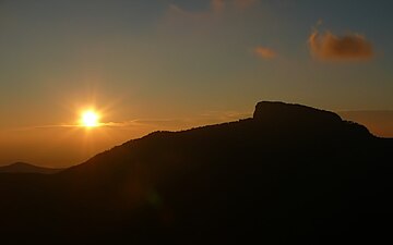
 Dogback Ridge as seen from Wiseman's View | |
 Map of the United States | |
| Location | Burke County, North Carolina, USA |
| Nearest city | Morganton, North Carolina |
| Area | 11,786 acres (48 km2) |
| Designation | 1964 |
| Designated | Wilderness Area |
| Governing body | United States Forest Service |
| Website | Linville Gorge Wilderness |
The Linville Gorge Wilderness ("The Grand Canyon of North Carolina") is the third largest
Popular tourist attractions in or near the wilderness are[citation needed]:
- Linville Falls, a waterfall fed by the river and free to the public.
- Wiseman's View, a rock outcrop near the center of the gorge that gives an excellent view of the interior of the gorge.
- Linville Caverns, a privately maintained cave attraction accessible by automobile from U.S. Route 221.
History
Prior to the European colonization of North America, virtually all of western North Carolina was inhabited by tribes of the Cherokee Indians. In the Cherokee language, the Linville River is called Ee-see-oh, which means "river of many cliffs" when literally translated.[2][3] Early white settlers named the river Linville in honor of John and William Linville, explorers who were scalped by the Shawnee[4] in the gorge in 1766.[3]
The steepness of the sides, the depth of the gorge, and the peaks of the Jonas Ridge to the east and Linville Mountain to the west made settlement impractical in the 1800s and 1900s. In the early 20th century,
Formal protection of the area began in 1952, when the land was purchased with funds donated by

Camping and hiking
Due to the nature of the terrain, hiking in the Linville Gorge can be a strenuous and challenging activity. Maps of the trail system are available through
In order to maintain the quality of the wilderness, camping in the gorge is managed by the Grandfather Ranger District of the United States Forest Service. Group sizes are limited to no more than ten people, and free permits are required on weekends and holidays from 1 May until 31 October each year. Permits are restricted to one stay per group per month, and for no longer than three days and two nights per visit.[citation needed]
Hunting and fishing
Game animals such as deer, black bear, wild turkey, and gray squirrel are common in the gorge. As part of the Pisgah Game Lands established by the North Carolina Wildlife Resources Commission, hunting is legal in the area in keeping with local seasons and hunting regulations. In actual practice, hunting in the Linville Gorge is fairly rare, due to the difficult, inaccessible terrain and the presence of campers and hikers who are often unfamiliar with hunting seasons.[citation needed]
The Linville River is included in the NC Wildlife trout stocking program, and fishermen are occasionally seen in the gorge seeking brown, brook, and rainbow trout. Once again however, the terrain requires a long hike down the steep sides of the gorge to reach the river, and a long difficult hike back, so fishing is more common on the river above and below the gorge section.[citation needed]
Climbing
Rock climbing is allowed anywhere in the area, but due to nesting
Photo gallery
-
 Sunrise over Table Rock
 -
 Babel Tower
 -
 Hawksbill and Sitting Bear as seen from Wiseman's View
 -
 Linville Falls at the northern end of Linville Gorge
 -
 Wiseman's View
 -
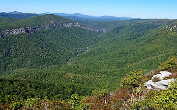 The Linville Gorge as seen from the top of Table Rock
 -
 Climbers in the Linville Gorge
 -
 Linville Gorge from Wiseman's View
 -
 Hawksbill Mountain as seen from Dogback Ridge
 -
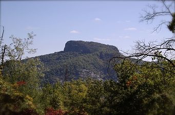 Table Rock as seen from Dogback Ridge
 -
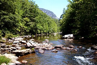 View of the Linville River
 -
 Southeast Canyon Wall
 -
 Lake James and surrounding area from southern end of Linville Gorge
 -
 Sunrise from Wiseman's View
 -
 Springtime at Wiseman's View
 -
 Sunset from Wiseman's View
 -
 Gorge and Hawksbill from Wiseman's View


See also
References
- ^ a b "National Wilderness Preservation System Search". Archived from the original on 2009-08-20. Retrieved 2007-12-18.
- ISBN 0-8078-4851-4.
- ^ a b "Linville Gorge - Field Guide to Place Names". Retrieved 2007-07-13.
- ^ US Forest Service interpretive sign at Linville Falls
- ^ Mary Byrd Davis (23 January 2008). "Old Growth in the East: A Survey. North Carolina" (PDF). Archived from the original (PDF) on 17 February 2012.
- ISBN 0-89732-391-2.
- ISBN 0-87049-806-1.
External links
- linvillegorge.net.
- Effects of Future Sulfate and Nitrate Deposition Scenarios on Linville Gorge and Shining Rock Wildernesses United States Department of Agriculture
.jpg)