
Botevgrad
Botevgrad
Ботевград | |
|---|---|
Town | |
 View of Botevgrad from the Chekanitsa area | |
|
UTC+3 (EEST) | |
| Postal Code | 2140 |
| Area code | 723 |
| Website | www |
Botevgrad (Bulgarian: Ботевград [ˈbɔtevɡrat]) is a town in western Bulgaria. It is located in Sofia Province and is close to Pravets. Botevgrad lies 47 km from Sofia.
History and name
The village was called Samundzhievo (Самунджиево) until it was elevated to town status at the end of 1865 under the name of Orhanie (Bulgarian language: Орхание; Ottoman Turkish: اورخانيه).[1] On 1 December 1934 the town was named Botevgrad (Ботевград) after Hristo Botev.
Geography
Botevgrad and its hinterland are located in an elliptical valley with a total area of 5,066 km2. The municipality covers parts of the Western
Climate
| Climate data for Botevgrad, Bulgaria | |||||||||||||
|---|---|---|---|---|---|---|---|---|---|---|---|---|---|
| Month | Jan | Feb | Mar | Apr | May | Jun | Jul | Aug | Sep | Oct | Nov | Dec | Year |
| Record high °C (°F) | 18.8 (65.8) |
22.9 (73.2) |
33 (91) |
30 (86) |
35.5 (95.9) |
37.7 (99.9) |
38.5 (101.3) |
41.2 (106.2) |
41 (106) |
34.6 (94.3) |
26.8 (80.2) |
21 (70) |
41.2 (106.2) |
| Mean daily maximum °C (°F) | 4.6 (40.3) |
6.7 (44.1) |
11.5 (52.7) |
17.8 (64.0) |
22.4 (72.3) |
26.1 (79.0) |
29.2 (84.6) |
29.6 (85.3) |
25.1 (77.2) |
18.5 (65.3) |
12.4 (54.3) |
6.1 (43.0) |
17.6 (63.7) |
| Daily mean °C (°F) | 0.0 (32.0) |
2.1 (35.8) |
6.4 (43.5) |
12.3 (54.1) |
17.1 (62.8) |
20.4 (68.7) |
23.1 (73.6) |
23.1 (73.6) |
19.1 (66.4) |
12.9 (55.2) |
7.6 (45.7) |
2.5 (36.5) |
12.2 (54.0) |
| Mean daily minimum °C (°F) | −4.6 (23.7) |
−3.1 (26.4) |
1.1 (34.0) |
6.7 (44.1) |
10.8 (51.4) |
13.8 (56.8) |
16.0 (60.8) |
15.7 (60.3) |
12.3 (54.1) |
7.2 (45.0) |
3.1 (37.6) |
−1.5 (29.3) |
6.5 (43.7) |
| Record low °C (°F) | −31.9 (−25.4) |
−29.5 (−21.1) |
−25.4 (−13.7) |
−4.3 (24.3) |
−0.8 (30.6) |
4.3 (39.7) |
6.2 (43.2) |
5.7 (42.3) |
−1.2 (29.8) |
−4.3 (24.3) |
−12.8 (9.0) |
−22.5 (−8.5) |
−31.9 (−25.4) |
| Average precipitation mm (inches) | 45 (1.8) |
38 (1.5) |
49 (1.9) |
67 (2.6) |
104 (4.1) |
117 (4.6) |
84 (3.3) |
60 (2.4) |
60 (2.4) |
58 (2.3) |
57 (2.2) |
48 (1.9) |
787 (31.0) |
| Source: Stringmeteo.com[2] | |||||||||||||
Nature
The region of Botevgrad municipality is quite rich in
The bottom of the hollow is the accumulative river terrace of Bebresh river and its tributaries. The low oval hills inside the hollow contribute to the countryside variety. Mount Murgash — 1687 m tall is the highest point of the highest mountain range to the south and south-west. Many rivulets run down the slopes of the heights. Prohoda Vitinya or Vitinya Pass connecting South Bulgaria with North Bulgaria is located on the territory of Botevgrad municipality.
Economy
Sensata Technologies group, which specialises in the design and production of added value electronics and electromechanical systems used in the automotive and consumer electronics industry, operates one large production plant in the town.
GE Pharmaceuticals operates a drugs factory and in 2006 Siemens opened a plant for the production of high voltage transformers.
Integrated Micro-Electronics, Inc., also known as IMI, is a provider of electronics manufacturing services (EMS) and power semiconductor assembly and test services (SATS).
APS Advanced Printing Systems is a company involved in production of thermal printer mechanisms, controller boards and thermal printers.
Mikroak Ltd, Chavdar many other companies in and around the area of Botevgrad.
Sport
Botevgrad has one of the leading
Religion

The religious buildings in Botevgrad are:
- Church of the Ascension of Christ
- Dormition of the Mother of God Church
- Monastery "Nativity of the Mother of God" in the Zelin village zone
- United Methodist Church
Twin towns
Botevgrad is
Gallery
-
 Central Botevgrad
 -
 Court Hall and garden
 -
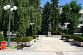 Botev monument and garden
 -
-
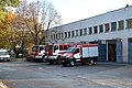 Fire trucks of the fire service
 -
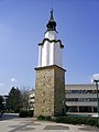
 Botevgrad house of science
 -
 Library Ivan Vazov


References
- ^ "Orhaniye (Botevgrad)". Ansiklopedika. 22 July 2022. Retrieved 23 July 2022.
- ^ "StringMeteo.com » Начало". www.stringmeteo.com.
External links
- Botevgrad directory
- Botevgrad's Municipal Site
- News About Botevgrad
- Botevgrad's Portal Site
- Pictures from Botevgrad
- 360 degree virtual Botevgrad picture of the centre

| International | |
|---|---|
| National | |