
Melnik, Bulgaria
Melnik
Мелник | |
|---|---|
Town | |
UTC+3 (EEST) | |
| Postal Code | 2820 |
| Area code | 07437 |
Melnik (
History
According to archaeological evidence, the first to settle in the area were the

The Ottoman conquest of the Balkans in the 14th-15th century resulted in a long period of decline, but Melnik was once again a thriving town in the 17th and 18th century, the time of the Bulgarian National Revival, due to the tobacco and wine production,[2] with wine being exported abroad, mainly to England and Austria. In that time Melnik was also a centre of craftsmanship, particularly church decoration and woodcarving. Many Bulgarian schools and churches were built in Melnik in that period.

Melnik was taken by the
At the end of the Second Balkan War in 1913, the Greeks left Melnik and moved to Greece by the express orders of the Greek government; the order being given when it was known that Melnik was to be ceded to Bulgaria.

Climate
Melnik has a Mediterranean climate with hot summers and cool winters.
Climate table:
| Climate data for Melnik | |||||||||||||
|---|---|---|---|---|---|---|---|---|---|---|---|---|---|
| Month | Jan | Feb | Mar | Apr | May | Jun | Jul | Aug | Sep | Oct | Nov | Dec | Year |
| Mean daily maximum °C (°F) | 6.5 (43.7) |
8.8 (47.8) |
14.5 (58.1) |
20.9 (69.6) |
26.5 (79.7) |
31.2 (88.2) |
34.3 (93.7) |
34.7 (94.5) |
28.4 (83.1) |
21.5 (70.7) |
14.6 (58.3) |
7.5 (45.5) |
20.8 (69.4) |
| Daily mean °C (°F) | 2.6 (36.7) |
4.2 (39.6) |
8.7 (47.7) |
14.1 (57.4) |
20.1 (68.2) |
23.3 (73.9) |
26.2 (79.2) |
26.1 (79.0) |
21.3 (70.3) |
15.2 (59.4) |
8.7 (47.7) |
3.8 (38.8) |
14.6 (58.3) |
| Mean daily minimum °C (°F) | −1.7 (28.9) |
−0.8 (30.6) |
2.8 (37.0) |
7.1 (44.8) |
12.7 (54.9) |
15.6 (60.1) |
17.8 (64.0) |
18.0 (64.4) |
14.1 (57.4) |
8.7 (47.7) |
3.8 (38.8) |
0.1 (32.2) |
8.1 (46.6) |
| Average precipitation mm (inches) | 58 (2.3) |
49 (1.9) |
49 (1.9) |
54 (2.1) |
62 (2.4) |
59 (2.3) |
29 (1.1) |
21 (0.8) |
40 (1.6) |
54 (2.1) |
77 (3.0) |
63 (2.5) |
643 (25.3) |
| Source 1: stringmeteo.com[6][failed verification] | |||||||||||||
| Source 2: Hong Kong Observatory | |||||||||||||
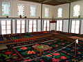
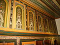
Sights and winemaking
The unique architecture of Melnik and the nearby Rozhen Monastery (located 6 km northeast of Melnik) make it a popular tourist destination. In addition, the town has been famous for producing strong wine since at least 1346. The local wine from the varietal Broad Leave Melnik Vine was reportedly a favourite of Winston Churchill's. Lately, the area of Melnik is enjoying a revival of vine growing and wine making. Several new, modern wineries have been built and operate (Villa Melnik Winery, Sintica Winery, Orbelus, etc.), producing high quality wine from local and international varieties.
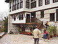
Interesting architectural landmarks include the
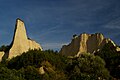
The area around Melnik is strikingly eroded, particularly the enormous area of cliff that serves as a backdrop to the town. This area, covering some 17 km2 near Melnik, Kurlanovo and Rozhen, has been called the Melnik Earth Pyramids or Melnik Badlands. The hills in this area can rise up to 100 metres (330 ft) high.[7] The unique formations, which can resemble giant mushrooms, ancient towers, and obelisks, were formed when heavy rain eroded the sand and clay the hills are composed of.[7]
Notable people
- Anastasios Polyzoidis a Greek politician and judicial official
- Anastasios Christomanos, Greek chemist
- Emanuil Vaskidovich a Bulgarian National Revival enlightener of Greek descent
- Ilija Antonovic a Serbian merchant and a great benefactor
- Ivan Anastasov an IMRO revolutionary of Greek descent
Honours
Melnik Ridge[8] and its summit Melnik Peak[9] on Livingston Island in the South Shetland Islands, Antarctica are named for Melnik.
Gallery
-
 Overview
 -
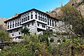 The Kordopulov House in winter
 -
 The famous sand pyramids
 -
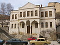 The Ottoman konak
 -
 Basilica of St Anthony (1765)
 -
 The Byzantine House (12th–13th century)
 -
-
 Ruins of the St Nicholas Church
 -
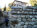
 Despot Slav's Fortress
 -
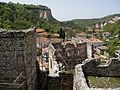
 View of Melnik
 -

-
-
-
-

-
-

-

-

-

-

-

-

-


.JPG)


.JPG)
.JPG)
.JPG)
.JPG)
.JPG)
.JPG)

References
- ^ ISBN 1-86450-148-0.
- ISBN 0-906672-63-5.
- ISBN 1134800754, p. 83.
- ^ Kanchov, Vasil, Macedonia, Ethnography and Statistics, Sofia, 1900, book 2, p. 18. Written as "Мелникъ". (in Bulgarian)
- ^ ISBN 0-87003-032-9., pp. 202-204
- ^ "Климатични данни » България".
- ^ ISBN 0-89577-087-3.
- ^ Melnik Ridge. SCAR Composite Gazetteer of Antarctica.
- ^ Melnik Peak. SCAR Composite Gazetteer of Antarctica.
Further reading
- Kostova, Elena (2013). Medieval Melnik, from the End of the 12th Century to the End of the 14th Century: The Historical Vicissitudes of a Small Balkan Town. Sofia: American Research Center in Sofia. ISBN 978-954-92571-3-7.
External links
- D. M. Brancoff. La Macédoine et sa Population Chrétienne. Paris, 1905, 192–193
- Popovic, M. Die Siedlungsstruktur der Region Melnik in spätbyzantinischer und osmanischer Zeit. – Зборник радова Византолошког института, Т. 47 (2010), 247-276
- Todic, B. The Symbolical Investiture of the Archbishop Basil of Bulgaria at Melnik. – Zograf, 32 (2008), 59-68

| International | |
|---|---|
| National | |
| Other | |