
Carretera Austral
.svg) .svg) | |
|---|---|
| Ruta 7 | |
 Path of the highway. The dashed lines indicate unfinished part near Hornopirén | |
| Location | |
| Country | Chile |
| Highway system | |


The Carretera Austral (CH-7, in English: Southern Way) is the name given to Chile's Route 7. The highway runs south for about 1,240 kilometers (770 mi) from Puerto Montt to Villa O'Higgins, passing through rural Patagonia.[1]
Carretera Austral provides road access to Chile's
History

Construction of the highway was commenced in 1976[
As it was constructed during the military dictatorship, the Carretera Austral bears the unofficial name of the Augusto Pinochet highway.
Carretera Austral has a strategic meaning due to the difficult access by land to a significant portion of Chile's southern territory. This area is characterized by thick
The highway opened to traffic in 1988, and by 1996 was completed to Puerto Yungay. The last 100 kilometers (62 mi) to Villa O'Higgins were opened in 2000. In 2003, a branch road to Caleta Tortel was finished.[5]
Places along the highway
- Puerto Montt
- Reloncaví Sound
- Contao
- Hornopirén (Río Negro)
- Hornopirén National Park
- Yelcho Lake
- Pumalín Park
- Chaitén
- Queulat National Park
- Coyhaique
- Balmaceda
- Río Ibáñez
- Cerro Castillo
- General Carrera Lake
- Cochrane
- Baker River
- Confluence of the Baker River and the Nef River
- Patagonia Park
- Caleta Tortel
- Villa O'Higgins
Ferry crossings
Traveling the entire route requires the use of three ferry services:
- A 40-minute crossing about 45 kilometers (28 mi) south of the start of the highway in Puerto Montt, between Fishing Creeks "La Arena" and "Puelche". This ferry service runs 24/7 with departures approximately every 30 minutes during the day (while at night the activity decreases). During the summer (Dec–Feb) the number of departures is increased with boardings at every 15, 30 and 45 minutes. Passengers without a vehicle can board for free throughout the year.
- a 5-hour crossing from Hornopiren (110 kilometers (68 miles) south of Puerto Montt) to Caleta Gonzalo, which requires passengers to purchase tickets prior to boarding.
- a 50-minute crossing from Puerto Yungay to Rio Bravo, connecting to the final 100 kilometers (62 mi) of the highway.
Current activity
| Patagonia |
|---|
 |
| Regions |
|
Eastern Patagonia Western Patagonia Tierra del Fuego |
| Ecoregions |
| National parks |
|
Laguna San Rafael, Los Glaciares Nahuel Huapi, Torres del Paine Alberto de Agostini, Tierra del Fuego |
| Administrative division |
|
Chile Palena Province Aysén Region Magallanes Region Argentina Neuquén Province, Río Negro Province Chubut Province, Santa Cruz Province Tierra del Fuego Province |
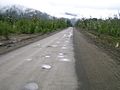
The highway began as almost entirely unpaved, but more sections are becoming paved each year. As of March 2018, the paved road ends at Villa Cerro Castillo, with roadworks going on just south of there.
There is also a plan to extend the road to
Gallery
-
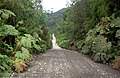
 Carretera Austral near Caleta Gonzalo
 -
 Carretera Austral near Caleta Gonzalo
 -
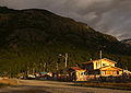 Villa O'Higgins, the end of Carretera Austral


References
- ^ "Carretera Austral - Presentacion; in Dirección de Vialidad" (in Spanish). Ministerio de Obras Públicas, Dirección de Vialidad. Archived from the original on 2008-05-21.
- ^ "Census 2002" (in Spanish).
- ^ "History of the Carretera Austral". TurismoChile.com. Archived from the original on 2008-09-19. Retrieved 2008-08-24.
- ^ a b c Rojas, Jorge (2013-09-07). "Carretera Austral: La pirámide del dictador". The Clinic. Retrieved 2023-10-04.
- ^ "Carretera Austral". Aisen Bridges Travel. Archived from the original on 2008-12-23.
- ^ "Carretera Austral - Nuevos trazados; in Dirección de Vialidad" (in Spanish). Ministerio de Obras Públicas, Dirección de Vialidad. Archived from the original on 2008-07-07.
External links
| International | |
|---|---|
| National | |