
Puerto Natales
Puerto Natales
Natales | |
|---|---|
 | |
|
 Coat of arms  Magallanes y Antártica Chilena | |
| Province | Última Esperanza |
| Commune | Natales |
| Founded | 1911 |
| Government
UTC−3 (CLST) | |
| Area code | 56 + 61 |
| Website | www.muninatales.cl |
Puerto Natales is a
It is located at the opening of
The city was settled in the late 19th century by European immigrants, primarily
The city was formally founded under the government of Ramón Barros Luco on May 31, 1911. Nowadays, one of its most important industries is tourism although the cattle and aquaculture industries are also significant. While winds, colds and thin soils limit horticulture in Puerto Natales there is still a small-scale local produce of zucchini, cherry tomatoes, strawberries, cucumbers and carrots.[6]
History and current status
The province where Puerto Natales is located was named Última Esperanza (Last Hope) by the sailor Juan Ladrilleros, who was seeking the Strait of Magellan in the year 1557. It was his "last hope" to find the Strait after exploring the maze of channels between the waters of the Pacific and the mainland. It was not until three centuries later, in 1830, that another major expedition sailed through the fjords and channels of Última Esperanza: the British expedition of the sloop HMS Beagle. Some of the expedition members such as Robert FitzRoy, William Skyring and James Kirke as well as their senior officers are remembered by several place-names in the area. Commander Fitzroy was the captain during the Second voyage of HMS Beagle (1831–1836).
In 1870, interest in the region of Ultima Esperanza was rekindled. Among the daring travelers who ventured to these desolate lands was Santiago Zamora, also known as 'Baqueano' Zamora. He discovered the lakes of the

Puerto Natales was founded in May 1911 as a port for the sheep industry. During the last half of the 20th century the sheep industry declined and many people from Puerto Natales started to work in the coal mines of Río Turbio in Argentina. During the zenith of the sheep industry in Patagonia, two large "frigorificos" or cold-storage plants were constructed in the Natales area, of which one has survived.[8] The plant at Puerto Bories, about 4 km NW from Puerto Natales, was a project of the Sociedad Explotadora de Tierra del Fuego. The Puerto Bories site was inaugurated in 1913 and was in production until 1993. The Cold-Storage Plant was constructed in "Post Victorian Industrial" architectural style and features of number of British machinery examples which reflect the technology of the beginning of the 20th century. The Cold-Storage Plant complex is part of the industrial history of the Puerto Natales area. A restoration project made by The Singular Hotels, was started on the complex in 2010 in order to transform the cold storage plant into a luxury hotel, called The Singular Patagonia.[9]
In 1919, a strike by the Federación Obrera de Magallanes resulted in the workers taking control of the town.[10] The strike was later suppressed by the government.[11]
Tourism
- Torres del Paine National Park
Puerto Natales has many tourist facilities, and it has become a common base for excursions to the world-renowned
- Cueva del Milodón Natural Monument
Twenty four kilometres (15 mi) northwest of Puerto Natales, along the flanks of the
- Nao Victoria Museum[16]
A museum in nearby
- Navigate the fjords
Companies offering boat trips through the Patagonian fjords depart from Puerto Natales Pier and take tourists to view the region’s many icebergs.
- Bike, horseback and kayak expeditions
Bike trips around Torres del Paine National Park are a quiet way to admire the nature and the majestic sights. On horseback you can visit the characteristic farms that dot the countryside around Puerto Natales. Kayaks offer a quieter alternative to boat trips and are a perfect platform to admire the landscapes of the fjords from a different point of view.
- Facilities
Today, there are dozens of camping sites, hostels, hotels, bed & breakfasts, restaurants and transportation services to fit a variety of budgets.[18]
- How to get there
There are daily
Demographics

According to the 2002 census carried out by the Chilean National Statistics Institute, the Natales commune has a population of 19,116 inhabitants (10,068 men and 9,048 women). Of these, 16,978 (88.8%) lived in the city’s urban area and 2,138 (11.2%) in rural areas. The population grew by 10.7% (1,841 persons) between the 1992 and 2002 censuses. The commune comprises 96.3% of the provinces’s total population of 19,855.[3] Its population density is only 0.38/km2 (0.98/sq mi).
Geography
Puerto Natales is situated along the shore of Última Esperanza Sound and has views northward into the
The city of Puerto Natales exists within the larger Natales commune, one of eleven communes in the Magallanes Region. Since the entire province of Última Esperanza (56,554 km2 (21,836 sq mi)) is divided into only two communes, the result is a rather large but sparsely populated area for the Natales commune. The commune's area is 48,974.2 km2 (18,909 sq mi),[3] which renders it one of the largest communes in Chile, larger than seven regions of the country.
Its altitude is 3 m (10 ft).
Climate
Puerto Natales has a oceanic climate (Köppen: Cfb/Cfc), with cool, short summers, and chilly, wet winters. It is the city with most rainy days per year in Chile, averaging 161.[19]
| Climate data for Puerto Natales (1991–2020, extremes 1991–present[a]) | |||||||||||||
|---|---|---|---|---|---|---|---|---|---|---|---|---|---|
| Month | Jan | Feb | Mar | Apr | May | Jun | Jul | Aug | Sep | Oct | Nov | Dec | Year |
| Record high °C (°F) | 27.2 (81.0) |
30.0 (86.0) |
28.6 (83.5) |
24.1 (75.4) |
18.5 (65.3) |
18.4 (65.1) |
16.1 (61.0) |
16.8 (62.2) |
19.8 (67.6) |
20.3 (68.5) |
26.5 (79.7) |
24.8 (76.6) |
30.0 (86.0) |
| Mean daily maximum °C (°F) | 18.8 (65.8) |
18.1 (64.6) |
18.1 (64.6) |
14.3 (57.7) |
10.9 (51.6) |
6.9 (44.4) |
7.7 (45.9) |
8.9 (48.0) |
12.2 (54.0) |
14.0 (57.2) |
15.6 (60.1) |
17.2 (63.0) |
13.6 (56.4) |
| Daily mean °C (°F) | 11.6 (52.9) |
11.5 (52.7) |
10.1 (50.2) |
6.7 (44.1) |
3.7 (38.7) |
1.9 (35.4) |
1.7 (35.1) |
2.9 (37.2) |
5.2 (41.4) |
7.1 (44.8) |
8.9 (48.0) |
10.5 (50.9) |
6.8 (44.3) |
| Mean daily minimum °C (°F) | 4.5 (40.1) |
4.2 (39.6) |
2.6 (36.7) |
−0.3 (31.5) |
−2.9 (26.8) |
−4.0 (24.8) |
−4.0 (24.8) |
−3.3 (26.1) |
−0.5 (31.1) |
−1.6 (29.1) |
2.0 (35.6) |
3.8 (38.8) |
0.0 (32.1) |
| Record low °C (°F) | −2.4 (27.7) |
−7.4 (18.7) |
−6.8 (19.8) |
−8.8 (16.2) |
−10.4 (13.3) |
−13.1 (8.4) |
−18.8 (−1.8) |
−10.8 (12.6) |
−8.2 (17.2) |
−8.0 (17.6) |
−4.1 (24.6) |
−4.1 (24.6) |
−18.8 (−1.8) |
| Average precipitation mm (inches) | 147 (5.8) |
120 (4.7) |
145 (5.7) |
154 (6.1) |
119 (4.7) |
105 (4.1) |
104 (4.1) |
107 (4.2) |
103 (4.1) |
127 (5.0) |
154 (6.1) |
155 (6.1) |
1,540 (60.7) |
| Average precipitation days | 16 | 13 | 15 | 13 | 12 | 12 | 12 | 12 | 12 | 13 | 15 | 16 | 161 |
| Average relative humidity (%)
|
73 | 74 | 76 | 81 | 85 | 86 | 85 | 83 | 80 | 74 | 73 | 72 | 79 |
| Mean daily sunshine hours | 7.6 | 7.0 | 6.0 | 4.9 | 4.4 | 3.8 | 3.9 | 5.1 | 5.8 | 6.8 | 7.5 | 7.6 | 5.9 |
| Source 1: Dirección Meteorológica de Chile (normal temperatures and extremes)[20][21] | |||||||||||||
| Source 2: Climate-Data.org[22][23] | |||||||||||||
Note
- ^ Please enter the value "510005" in the parameter "Estación"
Administration
The city of Puerto Natales is the capital of the Natales commune and the Última Esperanza Province. As a commune, Natales is a third-level
- Ana Mayorga Bahamonde (UDI)
- Veronica Pérez Magdalena (IND-UDI)
- Daniel Cordova Cordova (IND-UDI)
- Alfredo Alderete Flores (IND-Nueva Mayoría)
- José Cuyul Rogel (PS)
- Guillermo Ruiz Santana (PS)
Within the
Gallery
-
 Flamingos in Puerto Natales
 -
 Typical houses in Puerto Natales
 -
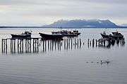
 A pier
 -
 A view of the city
 -
 Monument to explorer Juan Ladrillero in Puerto Natales
.jpg)
.jpg)


See also
Notes
- ^ a b "Asociación Chilena de Municipalidades" (in Spanish). Retrieved 27 January 2011.
- ^ a b "Municipality of Puerto Natales" (in Spanish). Retrieved 27 January 2011.
- ^ a b c d e "National Statistics Institute" (in Spanish). Retrieved 27 January 2010.
- ^ Mary Heebner, Patagonia, La Última Esperanza
- ^ Arriagada, Ramón (2004). Juan Ladrillero, el Navegante Olvidado (1st ed.). Puerto Natales: Editorial Fiordo Azul.
- ^ "Frente a la adversidad del clima: El desafío de cultivar hortalizas en la zona más austral del mundo". Cooperativas de Chile (in Spanish). 2019-08-05. Retrieved 2023-01-06.
- ^ "Welcome". Hotel Lady Florence Dixie. Retrieved 9 September 2016.
- ^ Duncan Campbell; Gladys Grace. "patbrit".
- ^ "The Hotel". The Singular Patagonia. Archived from the original on 28 January 2017. Retrieved 9 September 2016.
- ISBN 978-0-8047-4599-4.
- ISBN 978-0-8047-4599-4.
- ^ "Torres del Paine". Archived from the original on 2012-08-24. Retrieved 2013-08-19.
- ^ www.torresdelpaine.com www.torresdelpaine.com retrieved August 5, 2012
- ^ a b C. Michael Hogan, Cueva del Milodon, Megalithic Portal, 13 April 2008 [1]
- ^ Ciudad de Puerto Natales: Cueva del Milodon Archived 2009-10-18 at the Wayback Machine
- ^ Atlas Vivo de Chile – Nao Victoria www.atlasvivodechile.com Retrieved August 19, 2013
- ^ Nao Victoria replica Archived 2018-07-14 at the Wayback Machine www.atlasvivodechile.com retrieved August 8, 2012
- ^ Top 10 hotels in Puerto Natales, Patagonia, Chile Sarah Gilbert, theguardian.com, Wednesday 19 September 2012, retrieved August 6, 2013
- ^ "La ciudad en la que más llueve en todo Chile: publican ranking mundial". AS (in Spanish). 2022-10-12.
- ^ "Temperaturas Medias y Extremas en 30 Años-Entre los años: 1991 al 2020-Nombre estación: Chacalluta, Arica Ap" (in Spanish). Dirección Meteorológica de Chile. Archived from the original on 27 May 2023. Retrieved 27 May 2023.
- ^ "Temperatura Histórica de la Estación" (in Spanish). Dirección Meteorológica de Chile. 2023-05-26.
- ^ "PUERTO NATALES CLIMATE". Climate-Data.org. Retrieved 27 May 2023.
- ^ https://climatologia.meteochile.gob.cl/application/publicaciones/documentoPdf/climaHoy/climaHoy20230726.pdf
External links
- Panoramic virtual tour of Última Esperanza Sound from Puerto Natales
- Puerto Natales at Join Chile
- Puerto Natales at the Tourist Board of Chile
| Última Esperanza |  | |
|---|---|---|
| Magallanes | ||
| Tierra del Fuego | ||
Antártica Chilena |
| |