Carshalton Urban District
| Carshalton | |
|---|---|
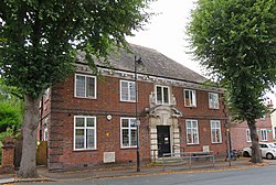
 Carshalton Council Offices | |
| Area | |
| • 1911 | 2,926 acres (11.8 km2) |
| • 1961 | 3,346 acres (13.5 km2) |
| Population | |
| • 1901 | 6,746 |
| • 1961 | 57,484 |
| History | |
| • Created | 1883 |
| • Abolished | 1965 |
| • Succeeded by | London Borough of Sutton |
| Status | urban district from 1894 |
| Government | |
| • HQ | The Square, Carshalton (later the local library) |
| • Motto | Animo et Fide (By Courage and Faith) |
 | |
Carshalton was a local government district in north east Surrey from 1883 to 1965 around the town of Carshalton.
The
urban district, and an elected urban district council replaced the local board.[1] In 1933 the boundaries of the district were altered after the abolition of Epsom Rural District.[2]
The district was abolished in 1965 by the London Government Act 1963 and the former area was transferred to Greater London to be combined with that of other districts to form the present-day London Borough of Sutton.[3]
Carshalton Urban District Council were granted
Carshalton Beeches.[5]
The council met in the Carshalton Council Offices in The Square. The building has been Grade II listed since 1974.[6]
References
- ^ Parishes: Carshalton, A History of the County of Surrey: Volume 4 (1912), pp. 178-188 (British History Online), accessed February 7, 2008
- ^ Frederic A Youngs Jr., Guide to the Local Administrative Units of England, Vol.I: Southern England, London 1979
- ^ "Local Government Act 1963". Legislation.gov.uk. Retrieved 25 April 2020.
- ^ Carshalton Urban District (Civic Heraldry) accessed 15 Jan 2008
- ^ C W Scott-Giles, Civic Heraldry of England and Wales, 2nd edition, London, 1953
- ^ Historic England. "Carshalton Public Library (1300429)". National Heritage List for England. Retrieved 2 August 2020.

