
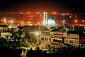
Chabahar
Chahbahar
چابهار | |
|---|---|
Home nant | |
UTC+3:30 (IRST) | |
| Website | chabahar |
Chābahār (ⓘ) (Persian: چابهار, Balochi: چھبار, romanized: čahbàr; transl. 'four springs' or 'spring well';[3][failed verification] formerly Bandar Beheshtī)[4] is a city in the Central District of Chabahar County, Sistan and Baluchestan province, Iran, serving as capital of both the county and the district.[5] It is a free port (free-trade zone) situated on the coast of the Gulf of Oman, and is Iran's southernmost city. The sister port city of Gwadar in Balochistan, Pakistan, is located about 170 kilometres (110 mi) to the east of Chabahar.
The city is situated on the
At the 2006 census, the city's population was 71,070 in 13,837 households.[6] The following census in 2011 counted 85,633 people in 19,313 households.[7] The latest census in 2016 showed a further increase in population to 106,739 people in 25,896 households.[2]
Etymology
The name Chabahar is a shortened form of the Balochi phrase chahar bahar (Persian: چهاربهار), where chahar means "four" and bahar means "spring". Hence, Chabahar means a place where all four seasons of the year resemble spring time.[citation needed]
History
There is a fishing village and former port named
Modern Chabahar dates back to around 1970 C.E., when it was declared a municipality and large port projects were started by order of
Economic significance


Chabahar is Iran's closest and best access point to the Indian Ocean. For this reason, Chabahar is the focal point of Iranian development of the east of the country through expansion and enhancement of transit routes among countries situated in the northern part of the Indian Ocean and Central Asia.[10] The hope is that with the development of transit routes, and better security and transit services, the benefits will reach the local residents.[according to whom?]
Chabahar's economic sectors are fish industries and commercial sector, fishery sectors with the largest amount of country's fish catch, mainly located out of the Chabahar Free Trade-Industrial Zone. Growing commercial sector located at free trade area with high potentiality to turn to a place that would connect business growth centers in south Asia (India) and Middle East (Dubai) to central Asian and Afghanistan market. The government plans to link the Chabahar free trade area to Iran's main rail network, which is connected to Central Asia and Afghanistan as well.[citation needed]
The city is served by Refah Chain Stores Co., Iran Hyper Star, Isfahan City Center, Shahrvand Chain Stores Inc., Ofoq Kourosh chain store.
Transportation
Chabahar is connected to
In July 2016, India began shipping US$150 million worth of rail tracks to Chabahar[11] to build US$1.6 billion Chabahar–Zahedan railway by India's Ircon International, for which India pledged additional US$400 million and Iran has also allocated US$125 million in December 2016, thus taking the total allocation to US$575 million (out of US$1.6 billion needed) till the end of 2016.[12]
Port

India, Iran and Afghanistan have signed an agreement to give Indian goods, heading for Central Asia and Afghanistan, preferential treatment and tariff reductions at Chabahar.
Work on the Chabahar–
Interest in Chabahar port's project renewed once
India and Iran are discussing building a gas pipeline between the two countries along the bed of the Arabian Sea to bypass Pakistan, using the Chabahar port. Both the countries are pondering the delivery of natural gas produced in Turkmenistan with Indian assistance to north Iran while the Islamic Republic will send natural gas from its southern deposits to Indian consumers. This pipeline is conceived by India to replace the proposed Iran–Pakistan gas pipeline, the negotiations for which have dragged on due to the worsening of relations between India and Pakistan.[14]
Railway line from Bamiyan province in Afghanistan
Religion
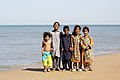
A majority of Chabahar's people are

Tourism

A $500 million resort is planned to be built in Chabahar.[16]
Climate
The county of Chabahar has hot, humid weather in the summer and warm weather in the winter, giving it a
| Climate data for Chabahar (1991-2020, extremes 1963-2020) | |||||||||||||
|---|---|---|---|---|---|---|---|---|---|---|---|---|---|
| Month | Jan | Feb | Mar | Apr | May | Jun | Jul | Aug | Sep | Oct | Nov | Dec | Year |
| Record high °C (°F) | 33.2 (91.8) |
33.0 (91.4) |
38.0 (100.4) |
42.0 (107.6) |
46.0 (114.8) |
45.2 (113.4) |
47.0 (116.6) |
42.4 (108.3) |
42.0 (107.6) |
41.4 (106.5) |
37.0 (98.6) |
32.0 (89.6) |
47.0 (116.6) |
| Mean daily maximum °C (°F) | 24.3 (75.7) |
25.1 (77.2) |
27.1 (80.8) |
30.3 (86.5) |
33.0 (91.4) |
33.7 (92.7) |
32.5 (90.5) |
31.3 (88.3) |
31.3 (88.3) |
31.4 (88.5) |
29.2 (84.6) |
26.2 (79.2) |
29.6 (85.3) |
| Daily mean °C (°F) | 20.7 (69.3) |
21.8 (71.2) |
23.9 (75.0) |
27.1 (80.8) |
30.1 (86.2) |
31.2 (88.2) |
30.3 (86.5) |
29.1 (84.4) |
28.7 (83.7) |
27.9 (82.2) |
25.2 (77.4) |
22.3 (72.1) |
26.5 (79.8) |
| Mean daily minimum °C (°F) | 16.6 (61.9) |
17.9 (64.2) |
20.5 (68.9) |
24.0 (75.2) |
27.2 (81.0) |
29.0 (84.2) |
28.7 (83.7) |
27.6 (81.7) |
26.6 (79.9) |
24.4 (75.9) |
20.9 (69.6) |
17.9 (64.2) |
23.4 (74.2) |
| Record low °C (°F) | 7.0 (44.6) |
7.0 (44.6) |
9.6 (49.3) |
14.0 (57.2) |
16.0 (60.8) |
22.0 (71.6) |
21.0 (69.8) |
19.0 (66.2) |
19.0 (66.2) |
13.2 (55.8) |
9.0 (48.2) |
7.0 (44.6) |
7.0 (44.6) |
| Average precipitation mm (inches) | 35.1 (1.38) |
7.3 (0.29) |
18.1 (0.71) |
2.1 (0.08) |
0.0 (0.0) |
9.0 (0.35) |
3.9 (0.15) |
1.0 (0.04) |
0.1 (0.00) |
5.7 (0.22) |
9.6 (0.38) |
23.7 (0.93) |
115.6 (4.53) |
| Average precipitation days (≥ 1.0 mm) | 2.4 | 1.0 | 1.6 | 0.3 | 0.0 | 0.2 | 0.3 | 0.2 | 0.0 | 0.2 | 0.6 | 1.4 | 8.2 |
| Average relative humidity (%)
|
62 | 68 | 74 | 76 | 78 | 81 | 81 | 82 | 81 | 77 | 66 | 61 | 73.9 |
| Mean monthly sunshine hours | 248 | 233 | 245 | 271 | 300 | 250 | 188 | 209 | 243 | 277 | 266 | 258 | 2,988 |
| Source: ) | |||||||||||||
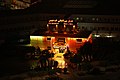
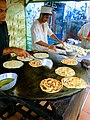
Gallery
-
 Chabahar Free Zone, Iran
 -
 Chabahar Free Zone, Iran
 -
 Chabahar Free Zone, Iran
 -
 Ferdows Hotel, Chabahar Free Zone, Iran
 -
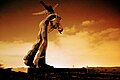 The statue of Chabahar Free Zone, Iran
 -
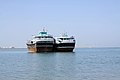
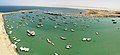 Beris port, Chabahar Free Zone, Iran
 -
-
-
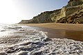
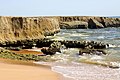
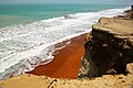 Elevated cliff beaches in suburbs of Chabahar Free Zone, Iran
 -
 The Lipar Pink Wetland, Chabahar Free Zone, Iran
 -
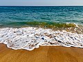
 Pozm Beach, Chabahar Free Zone, Iran
 -
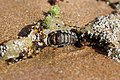
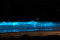 Planktons, Chabahar Free Zone, Iran
 -
 Planktons, Chabahar Free Zone, Iran
 -
 Comb beach, Chabahar Free Zone, Iran
 -
 Tis beach, Chabahar Free Zone, Iran
 -
 Comb beach, Chabahar Free Zone, Iran
 -
 Sany beaches of Chabahar Free Zone, Iran
 -
 Elevated cliff beaches of Chabahar Free Zone, Iran
 -
-
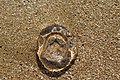 Jelly fishes, Chabahar Free Zone, Iran
 -

-
 Rocky Beach, Chabahar Free Zone, Iran
 -
 Rocky Beach, Chabahar Free Zone, Iran
 -
 Darya Koochak, Chabahar Free Zone, Iran
 -
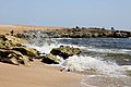 Rocky Beach, Chabahar Free Zone, Iran


See also
- Free Trade Zones in Iran
- International University of Chabahar
- Makran
- Chabahar Space Base
References
- ^ OpenStreetMap contributors (8 April 2023). "Chabahar, Chabahar County" (Map). OpenStreetMap. Retrieved 8 April 2023.
- ^ a b "Census of the Islamic Republic of Iran, 1395 (2016)". AMAR (in Persian). The Statistical Center of Iran. p. 11. Archived from the original (Excel) on 23 December 2021. Retrieved 19 December 2022.
- ^ "Inside Chabahar, the Iranian port city that borders Pakistan and where alleged spy Kulbhushan Jadhav was based". The Economic Times. 14 May 2017.
- ^ Chabahar can be found at GEOnet Names Server, at this link, by opening the Advanced Search box, entering "-3055106" in the "Unique Feature Id" form, and clicking on "Search Database".
- ^ Habibi, Hassan (21 June 1369). "Approval of the organization and chain of citizenship of the elements and units of the national divisions of Sistan and Baluchestan province, centered in the city of Zahedan". Research Center of the System of Laws of the Islamic Council of the Farabi Library of Mobile Users (in Persian). Ministry of Interior, Defense Political Commission of the Government Board. Archived from the original on 24 July 2013. Retrieved 29 December 2023.
- ^ "Census of the Islamic Republic of Iran, 1385 (2006)". AMAR (in Persian). The Statistical Center of Iran. p. 11. Archived from the original (Excel) on 20 September 2011. Retrieved 25 September 2022.
- ^ "Census of the Islamic Republic of Iran, 1390 (2011)". Syracuse University (in Persian). The Statistical Center of Iran. p. 11. Archived from the original (Excel) on 25 November 2022. Retrieved 19 December 2022.
- ^ Sachau, Edward C., ed. (1910) [first published 1888], Alberuni's India, Vol. 1, Kegan Paul, Trench, Trubner & Co, p. 208
- ISBN 0391041738
- ^ "India, China's rivalry and a tale of two ports". Reuters 2011-3-25. Retrieved 2011-5-12
- ^ India to export USD 150 million rails for Chabahar port next month
- ^ $125m for Chabahar-Zahedan Railroad
- ^ a b "India's $500 Million Bet on Iran". Foreign Policy. Retrieved 22 July 2016.
- ^ "Iran, India discuss building underwater gas pipeline". Tehran Times. Retrieved 25 December 2010.
- ^ "Judge refuses to hear plea against Sethi | The Frontier Post". Archived from the original on 4 March 2016. Retrieved 6 January 2012.
- ^ "$500m Tourist Resort Planned in Chabahar". Financial Tribune. 11 June 2017.
- ^ a b "اداره کل هواشناسی استان چهارمحال و بختیاری". www.chaharmahalmet.ir.
- NOAA. Retrieved 17 March 2024.
- ^ "Chahbahar Climate Normals 1963–1990". National Oceanic and Atmospheric Administration. Retrieved 29 December 2012.
External links
- http://www.iranchamber.com/people/articles/cultural_anthropology_of_baluchis.php
- https://web.archive.org/web/20141215001158/http://www.freezones.ir/Default.aspx?tabid=263
| International | |
|---|---|
| National | |