
Deister

The Deister is a chain of
It has a total length of 21 km (14 mi), and rises in the Hofeler to a height of 395 m (1,250 ft).[1] The highest point is the Bröhn at 405 m (1,312 ft).
The chain is well-wooded and abounds in game.
The Deister is a border region since ancient times. Here one can find many places with memorial stones, tumuli and ruins of castles.
Flora and fauna
The ridge is covered by a mixed forest of
-
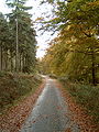 Spruce and beech wood along the Deister ridgeway
 -
 Dwarf beeches at the Feggendorf picnic site


Amongst the rarer plants on the Deister are species of
The Deister is home to the typical animals found in the German
Hills
Most of the hills in the Deister have a tower at the top, used for various purposes. The one on the Großer Hals is for telecommunications, while the one on the Höfeler is used for air traffic control. The others are for sightseeing and restaurants.
- Bröhn (405 m) and Anna Tower
- Höfeler (395 m) and air traffic control tower
- Reinekensiekskopf (382 m) and Nordmanns Tower
- Hohe Warte (379 m)
- Fahrenbrink (376 m)
- Großer Hals (361 m) and telecommunications tower
- Ebersberg (355 m)
- Bielstein (344 m) and refuge hut
- Egge (339 m)
- Kniggenbrink (312 m)
- Kalenberg (310 m)
- Strutzberg (198 m) and Belvedere Tower
52°15′N 9°30′E / 52.250°N 9.500°E
See also
Notes
- ^ a b c d One or more of the preceding sentences incorporates text from a publication now in the public domain: Chisholm, Hugh, ed. (1911). "Deister". Encyclopædia Britannica. Vol. 7 (11th ed.). Cambridge University Press. p. 937.

| International | |
|---|---|
| National | |