
Taunus
| Taunus | |
|---|---|
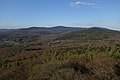
 The Hochtaunus with the Feldberg summit | |
| Highest point | |
| Peak | Großer Feldberg (Hochtaunus) |
| Elevation | 878 m (2,881 ft) |
| Coordinates | 50°14′N 08°27′E / 50.233°N 8.450°E |
| Dimensions | |
| Length | 75 km (47 mi) NE/SW |
| Width | 35 km (22 mi) NW/SE |
| Area | 2,700 km2 (1,000 sq mi) |
| Geography | |

| |
| Country | Rhenish Slate Mountains |
| Geology | |
| Orogeny | Variscan |
| Age of rock | Devonian |
| Type of rock | Phyllite, Greywacke |
The Taunus is a mountain range in Hesse, Germany, located north west of Frankfurt and north of Wiesbaden. The tallest peak in the range is Großer Feldberg at 878 m; other notable peaks are Kleiner Feldberg (825 m) and Altkönig (798 m).
The Taunus range spans the
Location and boundary
The Taunus is the southeastern part of the
On the southern edge are the towns of
Natural structure
The Taunus is a heterogeneous landscape area, but it is usually quite distinct from the surrounding landscapes and is classified as a main natural area unit group. The natural landscape is divided according to
In the south are the more wooded and higher parts, namely the Vordertaunus (naturally also called Vortaunus) and the Hohe Taunus (Taunus main ridge), where in the Feldberg massif the highest heights not only of the Taunus but of the entire Rhenish Slate Mountains are reached. That is why the climate here is rougher than in the upstream landscape areas - it is colder on average, it rains and, in particular, it snows more. The turbulent relief offers little space for settlements and agricultural use. On the mostly shallow and fertile soils, which developed from acidic rock, there is mainly forest here. The Vortaunus is more inconsistent than the main ridge, it is morphologically more fragmented and the bays of the foothills divide it more.
The Hintertaunus is divided into the
The Taunus (main unit group 30) is subdivided in terms of natural space as follows:[3][4]
- 300 Vortaunus (218.90 km2)
- 300.0 Rheingau-Wiesbadener Vortaunus (47.04 km2)
- 300.00 Rheingau-Vortaunus (28.00 km2)
- 300.01 Wiesbaden Vortaunus (19.04 km2)
- 300.1 Eppstein-Hornauer Vortaunus (101.66 km2)
- 300.10 Eppsteiner Horst (82.98 km2)
- 300.11 Hornau Bay (18.68 km2)
- 300.2 Altkönig vorstufe (48.49 km2)
- 300.20 Königstein foot of the Taunus (18.29 km2)
- 300.21 Kronberg Taunus foot (30.20 km2)
- 300.3 Homburg Vortaunus (21.71 km2)
- 300.0 Rheingau-Wiesbadener Vortaunus (47.04 km2)
- 301 High Taunus (314.92 km2)
- 301.0 Niederwald bei Rüdesheim(12.87 km2)
- 301.1 Rheingau Mountains (76.47 km2)
- 301.2 Wiesbaden High Taunus (71.43 km2)
- 301.3 Feldberg-Taunus crest (96.95 km2)
- 301.4 Winterstein-Taunuskamm (45.80 km2)
- 301.5 Nauheimer Taunusspur (11.40 km2)
- 302 Eastern Hintertaunus(825.66 km2)
- 302.0 Wetzlar Hintertaunus (165.88 km2)
- 302.1 Weilburger Hintertaunus (with Edelsberger Platte) (131.80 km2)
- 302.2 Bodenroder Kuppen (52.70 km2)
- 302.3 Hasselbacher Hintertaunus (169.83 km2)
- 302.4 Münster-Maibach threshold (26.30 km2)
- 302.5 Using Basin (87.50 km2)
- 302.6 Pferdskopf-Taunus (81.47 km2)
- 302.7 Steinfischbacher Hintertaunus (110.18 km2)
- 302.0 Wetzlar Hintertaunus (165.88 km2)
- 303 Idstein Valley (82.63 km2)
- 303.0 Golden Grund (31.74 km2)
- 303.1 Idsteiner Grund (24.39 km2)
- 303.2 Escher Grund (10.19 km2)
- 303.3 Idstein Forest (16.31 km2)
- 303.0 Golden Grund (31.74 km2)
- 304 Western Hintertaunus(908.38 km2)
- 304.0 Wispertaunus (145.05 km2)
- 304.1 Western Aartaunus (82.66 km2)
- 304.2 Bad Schwalbach-Hohensteiner Aartal (22.32 km2)
- 304.20 Aar-Aubach-Grund (0.27 km2)
- 304.3 Eastern Aartaunus (184.56 km2)
- 304.4 Oberaarmulde (23.83 km2)
- 304.5 Zorn plateau (41.64 km2)
- 304.6 Middle Rhine Taunus (109.56 km2)
- 304.7 Unterlahn Heights (38.19 km2)
- 304.8 Nastätter Mulde (92.58 km2)
- 304.9 Katzenelnbogen plateau (167.99 km2)
- 304.90 Dörsbach/Mühlbach watershed (16.24 km2)
- 304.91 Lower Dörsbach-Tiefenbach area (34.42 km2)
- 304.92 Central Katzenelnbogen plateau (104.43 km2)
- 304.93 Schiesheim Aartal widening (12.90 km2)
- 304.0 Wispertaunus (145.05 km2)
Geology and minerals
The Taunus is geologically divided from south to north into the units Vordertaunus unit (also northern phyllite zone or metamorphic southern edge zone), Taunus ridge unit and Hintertaunus unit. Finally, south of the Lahn, the Taunus natural region has a share in the Lahn trough and the Giessen nappe.
Vordertaunus
The Vordertaunus Unit is a narrow zone of weakly metamorphic rocks such as phyllites, greenschists and sericite gneisses.[5] They are appear greenish through chlorite and epidote. The starting products of these rocks were mudstones and volcanic rocks. The rock strata occurring in the Vordertaunus are divided from north to south into the metavolcanic sequence, the Eppstein slate and the Lorsbach slate.[5]
The oldest
Taunus crest
To the north of the Vordertaunus is the Taunuscrest, also known as the High Taunus, which mainly consists of
The Graue Phyllite consist of
Hintertaunus
The largest unit of the Taunus in terms of area, the Hintertaunus unit, is mainly composed of the black rock series of the
The Hunsrück slate refers to a
The Middle Devonian to Lower Carboniferous of the Usinger Mulde is only about 250 m thick and strongly tectonically disturbed, in the Lahnmulde and Dillmulde typical rocks of this time such as
Geological structure
The strata of the Taunus were formed in the course of the Variscan Orogonese
In later uplift phases between the Late Jurassic and the
Mineral resources
The northwestern part of the
Due to its hardness, the Taunus quartzite was often mined in the past, currently only one quarry near Köppern is in operation. Some limestone and diabase quarries are still in operation in the part of the Lahnmulde that belongs to the Taunus. In addition, there are countless smaller quarries to supply the local population with building blocks.
History
The
After the
In past centuries the Taunus became famous among aristocrats for its therapeutic hot springs.[13]
Certain towns in the area, such as
Gallery
-
 The Taunus with the Grosser Feldberg viewed from Karben
 -
 The Winterstein and the tower on the Steinkopf from Karben
 -
 View from Atzelberg Tower along the main ridge of the Taunus
 -
 Frankfurt am Main, with the Taunus Mountains in the background
 -
 Rossert hilltop Hainkopf on the right belongs to the Anterior Taunus, Atzelberg mountain on the left is part of the High Taunus


References
- ^ "Ford Taunus Typ TC wird 40 Jahre - Beliebte Supernase mit Knudsen-Genen" (in German). Auto Bild. 23 February 2010. Retrieved 5 March 2019.
- ^ Lexikon-Institut Bertelsmann: Das moderne Lexikon in zwanzig Bänden (The modern lexicon in 20 volumes). Volume 18, 1972.
- ^ "Umweltatlas Hessen".
- ^ "Naturräumliche Gliederung von Rheinland-Pfalz" (PDF). geographie.giersbeck.de (in German). Retrieved 3 March 2024.
- ISBN 978-3-89675-740-1.
- ^ E. Reitz and others: A first record of Lower Ordovician (Arenig) on the southern edge of the Rhenish Slate Mountains in the Vordertaunus: the Bierstadt phyllite (Bl. 5915 Wiesbaden). In: Geological yearbook Hesse. 123, Wiesbaden 1995, pp. 25-38.
- ^ T. Klügel: Geometry and kinematics of a Variscan plate boundary - the southern edge of the Rheno-Hercynian in the Taunus. Thesis. University of Würzburg, 1995.
- ^ "GÜK300". www.hlnug.de. Retrieved 13 September 2023.
- ^ a b T. Kirnbauer: Geology, petrography and geochemistry of the pyroclastics of the Lower Ems/Lower Devonian (porphyroids) in the southern Rhenish Slate Mountains. (= Geological treatises Hessen. 92). Wiesbaden 1991.
- ^ D. Henningsen: On the origin and differentiation of the sandy rocks on the south-east edge of the Rhenish Slate Mountains. In: New yearbook for geology and paleontology. Monthly magazines, Stuttgart 1963, pp. 49-67.
- ^ A compendium of the pits that existed in the past is contained in Die Ore Veins of the Eastern Taunus; in R. Jakobus: Geological yearbook Hessen. Volume 120, Hessian State Office for Soil Research, Wiesbaden 1992.
- ISBN 3797309554(in German)
- ^ "Great Spas of Europe". UNESCO. Retrieved 10 March 2016. Lists Bad Ems, Bad Homburg vor der Höhe, and Wiesbaden among the 16 in total.
- ^ Heinz Biehn, Der Taunus. Hohe Wälder, weite Täler, warme Quellen. Amorbach 1972 (in German)
External links
 Media related to Taunus at Wikimedia Commons
- There is literature about Taunus in the Hessian Bibliography
- Umweltatlas Hessen: → Natur und Landschaft → Die Naturräume Hessens bzw. Naturräumliche Gliederung – Naturraum-Haupteinheit 30 (Taunus), auf atlas.umwelt.hessen.de
- Fremdenverkehrsinformationen, Taunus Tourist Service at taunus.info
- Webcams at taunus.info
- Taunus Nature Park at naturpark-taunus.de
- Feldberg Roman Fort circular path, at feldbergkastell.de
- Summits in the Taunus by isolation and prominence, at thehighrisepages.de
- Wehrheim, das Tor zur Bronzezeit im Usinger Land Archived 2018-01-27 at the Wayback Machine, Infos zu archäologischen Funden in Wehrheim, auf geschichtsverein-usingen.de
- Das Vortaunusmuseum at vortaunusmuseum.de
- map and aerial photo of the Taunus with boundaries, rivers and all important summits (Google Earth), at geographie.giersbeck.de#Taunus Placemarks

Subdivisions of the Rhenish Massif | ||
|---|---|---|
 | ||
| International | |
|---|---|
| National | |
| Geographic | |