
Dere Street
| Dere Street | |
|---|---|
| Roman Road | |
 Route of Dere Street | |
| Route information | |
| Length | 226 mi (364 km) [146 mi or 235 km Eboracum to Trimontium;
80 mi or 129 km Norman Britain |
Veluniate | |
| Location | |
| Country | United Kingdom |
| Road network | |
Dere Street or Deere Street is a modern designation of a
Name
The Roman name for the route is lost. Its English name corresponds with the
Portions of the road in Scotland were later known as
"Watling Street"
The
A small section of the old A68 route north in Corbridge is called Watling Street.[2] It should not, however, be confused with the traditional route between Canterbury and Wroxeter in the south nor with the Carlisle route to its west.

Roman route


Dere Street roughly corresponds to the Antonine Itinerary's 1st British route as far as Hadrian's Wall, although it began further south than York:[3][4]
| From north of Hadrian's Wall to Praetorium: | 156 Roman miles .
| |||
|---|---|---|---|---|
| From Bremenium | [Rochester], | To Coria [Corbridge], | 20 | |
| To Vindomora | [Ebchester], | 9 | ||
| To Vinovia | [Binchester], | 19 | ||
| To Cataractonium | [Catterick], | 22 | ||
Isurium |
[Aldborough], | 24 | ||
| Eboracum | [York], | 6th Victorious Leg., | 17 | |
| To Derventio | [Malton], | 7 | ||
| To Delgovicia | [unknown], | 13 | ||
| To Praetorium | [unknown], | 25 | ||
The road served to allow supplies and troops such as the legion garrisoned in York quick access to the eastern borderlands and, later, the eastern posts on Hadrian's Wall. The Itinerary's 2nd and 5th British routes, which split off to reach the western territories, share the route between Eboracum and Cataractonium. Forts were built along Dere Street to protect the route. It crossed Hadrian's Wall through a large fortified gateway later called the "Portgate" which was still visible a few hundred years ago.[5][6]
Modern route
The modern route omits the now-lost road south of York[10] but continues farther north along Roman roads either omitted by the compiler of the Antonine Itineraries or constructed after his time.
The route begins at
Dere Street crossed the River Tees over a stone arch bridge near the present-day Piercebridge Roman Fort ruins. Such bridges were rare in Roman Britain except for here in the far north.[12] The original bridge was replaced by one on a different alignment.[13] There is evidence of other minor realignments of Dere Street over the Roman period.[13]
The next river crossing occurred over the Wear near present-day Bishop Auckland.[14] At this point, the fort Vinovia guarded a branch road that turned off to the right heading for Durham, Chester-le-Street, and Newcastle. There, the Pons Aelius crossed the River Tyne.[15]
Dere Street, meanwhile, travels onward past
The route passes north into
Another well-preserved section rises through the Lammermuirs over
Archaeology
In 1994, construction of a garage at Cliffe exposed a section of the Roman road, and pottery and tile from the period were also found.[22][23] Raymond Selkirk suggested that the ruins on the south side of the Tees at Cliffe are the remains of a dam;[24] the archaeological television programme Time Team investigated this in 2009.[25]
Excavations in 2007 by CFA Archaeology at Dun Law, in advance of the construction of a wind farm access road, uncovered a section of the Dere Street Roman road there. The excavations revealed that this section of the road was laid over a palaeochannel using a latticework of logs and a mat of branchwood. There are only a handful of examples of such engineering work in Roman road construction. The archaeologists found that the wood used was locally sourced from the then depleted forests.[26]
Excavations in 2007 by AOC Archaeology at Newbridge, Edinburgh, discovered a section of the road, providing solid evidence for the road's location in that area, which the milestone at Ingliston and the temporary camps at Gogar had intimated.[27]
History

During the
After the destruction of the Border Abbeys during the "Rough Wooing" of Mary, Queen of Scots, by the Earl of Hertford's forces and during the Reformation of the Scottish Church, the route fell into disuse and disrepair. It was used mainly for driving livestock and occasional travellers daring enough to venture into the lawless border region.[29]
Dere Street continued in use between Durham and York in medieval times. Being limited by daylight, "about thirty miles in a day in winter on horseback and between thirty-six and forty in summer was what a man could do." Tough, vigorous men could walk from Darlington to York, and it was said that the quality of a horse could make the difference between a possible thirty and fifty miles per day. A wish to hear mass or the organisation of a train by the rich could shorten the travelling day to twenty miles.
Roads were described as so muddy and difficult between November and February that to finish the journey by daylight one could barely stop to eat; however a "royal highway" or alta via regia strata was passable in winter between York and Durham, and this could have been Dere Street. Heavy packhorse loads were taken on the route, for example 20 stone (130 kg) of wool. Clerics, traders and the nobility were more likely to travel than others, and some people rarely travelled at all. Travelling in style involved the use of carts for luggage, but carts bogged down in winter mud, so traders with packhorses travelled more easily in winter than the rich.[30]
See also
- Piercebridge Roman Bridge
- Roman roads in Britain
Gallery
-
 Legg's cross on Dere Street near Bolamin County Durham
 -
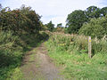
 Dere Street at Bildershaw, County Durham
 -
 Wheelbirks bridge, near Hindley, Northumberland
 -
 Milestone at West Woodburn, Northumberland
 -
 Dere Street at Bonjedward, Scottish Borders
 -
 Dere Street at Crailinghall, Scottish Borders
 -
 Dere Street at Maxton, Scottish Borders
 -
![Dere Street at King's Inch.[31] south of Soutra Aisle](//upload.wikimedia.org/wikipedia/commons/thumb/e/ed/Dere_Street_Gilston_Scottish_Borders.jpg/120px-Dere_Street_Gilston_Scottish_Borders.jpg) Dere Street at King's Inch.[31] south of Soutra Aisle
Dere Street at King's Inch.[31] south of Soutra Aisle


![Dere Street at King's Inch.[31] south of Soutra Aisle](/File:Dere_Street_Gilston_Scottish_Borders.jpg)
Notes
- ^ Watling Street, OS One Inch, 1885-1900, National Library of Scotland
- ^ Watling Street, Area Information for Watling Street, Corbridge, NE45 5AG
- ^ Itinerarium Antonini Augusti. Hosted at Latin Wikisource. (in Latin)
- ^ "The Antonine Itinerary". Roman Britain. (in Latin and English)
- ^ J C Bruce - The Handbook to the Roman Wall 8th edition 1927 Pg 67
- ^ David Divine - The North East Frontier of Rome 1969 Pg97
- ISBN 9780212970018.
- ^ Togodumnus. "Praesidivm/Praetorivm? Probable Roman Fort and Port". Roman Britain Online.
- ISBN 0-7524-2503-X.
- ^ Hayton, Richard (2003). "Yorkshire History.com". Roman military sites in Yorkshire. Retrieved 16 January 2010.
- ^ Davies, p. 93.
- ^ a b "From trackway to road". Archived from the original on 17 August 2010. Retrieved 9 August 2010.
- ^ Laurie, Barbara (2005). "bishopaucklandhistory.co.uk". A Short History of Bishop Auckland. Archived from the original on 10 February 2009. Retrieved 16 January 2010.
- ^ "Pastscape, English Heritage". Dere Street Investigation History. Archived from the original on 24 December 2012. Retrieved 16 January 2010. Publications : Full report Proceedings of the Society of Antiquaries of Newcastle upon Tyne 2/1925/12:94-6
- ^ Bishop, M. C. "Durham.ac.uk resources" (PDF). Corbridge (archaeological resources). Archived from the original (PDF) on 11 December 2009. Retrieved 16 January 2010.
- ^ Davies, p. 57.
- ^ a b "BBC". Dere Street – From York to Melrose in Seven Days. 10 June 2009. Retrieved 16 January 2010.
- ^ "Pennymuir camps under snow".
- ISBN 9781913836429
- ^ "Historic Scotland". Dere Street Roman Road. Retrieved 16 January 2010.
- ^ "Heritage Gateway". Listed buildings online, and local records. Archived from the original on 25 September 2005. Retrieved 11 January 2010.
- ^ NY SMR Number MNY12855; Old Sites & Monuments Record Number 12975.10000; Grid Reference NZ 212,155; SNY8056 Field recording Form, North Yorkshire County Council 15 November 1994, George Hotel Piercebridge (Dere Street Cottage), Campling, N. NYCC Observation Record
- ISBN 1-900456-05-2.
- ^ Lloyd, Chris (2 July 2009). "The Northern Echo". Piercebridge: Time Team investigates. Archived from the original on 27 September 2012. Retrieved 12 January 2010.
- ^ "Vol 57 (2014): Excavation across the Dere Street Roman Road at Dun Law, Scottish Borders | Scottish Archaeological Internet Reports". journals.socantscot.org. Retrieved 25 August 2021.
- ^ "Vol 59 (2016): A Roman Road Runs Through It: Excavations at Newbridge, Edinburgh | Scottish Archaeological Internet Reports". journals.socantscot.org. Retrieved 26 August 2021.
- ^ Hunter, James, FSA (Scot)., Fala and Soutra, including a History of the Ancient "Domus de Soltre", Edinburgh, 1892.
- ^ Scotways.com. "Heritage Paths". Dere Street. Archived from the original on 23 May 2022. Retrieved 16 January 2010.
- S2CID 162308071. Retrieved 16 January 2010.
- ^ King's Inch, OS 1:10,560, Series 1949-1969, National Library of Scotland
Further reading
- The Roads of Mediaeval Lauderdale, by R. P. Hardie, Edinburgh & London, 1942.