
Evolution of Worcestershire county boundaries since 1844

The administrative boundaries of Worcestershire, England have been fluid for over 150 years since the first major changes in 1844. There were many detached parts of Worcestershire in the surrounding counties, and conversely there were islands of other counties within Worcestershire. The 1844 Counties (Detached Parts) Act began the process of eliminating these, but the process was not completed until 1966, when Dudley was absorbed into Staffordshire.
The expansion of
Hereford & Worcester was re-divided into the separate counties of Herefordshire and Worcestershire in 1998. Since that time Worcestershire's boundaries have not changed. Redditch opted to join the West Midlands Combined Authority as an associate 'non-constituent' member in October 2015, although this will not affect the borough's status within Worcestershire.
Boundaries before 1844
The See of Worcester
The shiring of the See of Worcester also led to the formation of Gloucestershire - initially centred along the Severn Vale and Vale of Berkeley, through to the Mouth of the Severn.[7] In the east, Arden became part of Warwickshire, and Winchcombeshire straddled an area bounded by the River Avon, Vale of Evesham and the Cotswold Hills.[8] Winchcombeshire's existence was short-lived, and most of its parishes were absorbed into Gloucestershire upon dissolution. However, by the time of Domesday, some of Winchcombeshire's hypothesised former parishes were surveyed as detached exclaves of Worcestershire's Oswaldslow hundred.[9][10][11]
The High Sheriff of Staffordshire
By the time of Domesday, many of Worcestershire's exclaves in the south-east of the shire were already established. Meanwhile, to the north; during
It is not known exactly how much territory of Worcestershire was seized by Æfic and his successors in the late Anglo-Saxon period. The emergence of exclaves and enclaves in and around North Worcestershire, was in tandem with the appearance of Oswaldslow's exclaves to the south-east of the shire.
More parishes and manors changed hands over the coming decades through conquest or as 'gifts', some becoming enclaves within adjoining jurisdictions. The aftermath of the
Worcestershire's Hundreds
.png)
The early story of Worcestershire's initial twelve hundreds – Came, Clent, Cresselau, Cuthburgelow (Cuthbergehlawe), Doddingtree, Esch, Fishborough (Fisseberge), Pershore (along with the Abbot of Westminster's unnamed double hundred of displaced lands[16]), Winburgetreow, and Wulfereslaw, is largely unknown, including when they were established.[17] Cuthburgelow, Winburgetreow and Wulfereslaw became the triple-hundred of Oswaldslow by 1086,[17] administering the lands long held by the Bishop of Worcester and Priory.[18] Pershore's lands had been granted to the Abbot of Westminster during the reign of Edward the Confessor, thus becoming a triple-hundred.[19] Halfshire or Dimidii Comitatus de Wych[20][21] (Half of Wych(e)) was formed before 1175–76;[22] from an amalgamation of Came, Esch (except the possessions of Evesham Abbey, which became part of Blakenhurst) and the remnants of Clent, and consisted of land primarily owned by the Crown and Ansculf de Picquigny's successors. Halfshire was also known as the hundred of Dudley in 1275.[23][24] Doddingtree also belonged to the Crown,[25] whilst Fishborough/Fisseberge became known as Blakenhurst, who had a constant struggle to retain its lands from theft and conquest.[26] In seven of the shires twelve hundreds the Crown and its designated official, the High Sheriff of Worcestershire, had no authority. The Crown's authority was replaced by the Bishop of Worcester and the Abbots at Pershore, Westminster and Evesham.[27] This situation caused challenges within the legal framework and as acts of aggression where land was seized by force, or theft.[28][29] The gradual amalgamation of the initial twelve hundreds into five, plus the changing ownership of parishes and manors over the centuries created a very fractured layout.[30][31]
Warley Wigorn, Cradley and Bewdley

From the 11th Century; Halesowen Parish (or Hala) was gifted to the

Cradley was also retained by Worcestershire, along with the hamlet of Lutley which was held by the "Canons of Wolverhampton".[35][36] Other anomalies include the status of Bewdley, which was not formally in Worcestershire or Salop in the 15th century (despite being recorded as part of Worcestershire in the 14th Century), thus becoming a focus for criminals fleeing justice in either county. In 1544, Bewdley was formally designated part of Worcestershire.[37][38]
Exclaves and enclaves
As stated earlier, Worcestershire had an unusually large number of exclaves inside nearby counties, prior to 1844 (see Fig 2). This relationship with neighbouring counties mirrored the confusing and fragmented layout of parishes within Worcestershire's own hundreds (see images and table below). Meanwhile, Herefordshire, Staffordshire, Warwickshire and Shropshire had their own exclaves within the main part of Worcestershire at Rochford,[39] Broome,[40] Clent,[41] Tardebigge (Tutnall and Cobley)[42] and Halesowen respectively. Tardebigge's history outside the county is even more colourful, changing hands from Worcestershire to Staffordshire and Warwickshire, before returning to Worcestershire at differing times over the centuries.[43]
- The exclaves and enclaves of Worcestershire
-
 Fig 2: The County of Worcestershire (1832)
 -
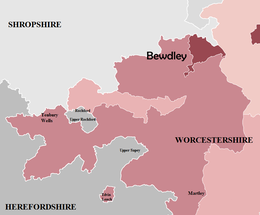 Fig 2A: North West Worcestershire
 -
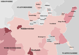 Fig 2B: North Worcestershire
 -
 Fig 2C: South and South East Worcestershire


| Fig | Exclave/enclave | County (before 1844) | Year and county of transfer | Government legislation | |
|---|---|---|---|---|---|
| 2C | Alderminster | Worcestershire | 1931 – Warwickshire | Provisional Order Confirmation (Gloucestershire, Warwickshire and Worcestershire) Act 1931 | |
| 2C | Alstone, including Alderton | Worcestershire | 1844 – Gloucestershire | Counties (Detached Parts) Act 1844 | |
| 2C | Blockley, including Paxford and Aston Magna | Worcestershire | 1931 – Gloucestershire | Provisional Order Confirmation (Gloucestershire, Warwickshire and Worcestershire) Act 1931 | |
| 2B | Broome | Staffordshire | 1844 – Worcestershire | Counties (Detached Parts) Act 1844 | |
| 2B | Clent | Staffordshire | 1844 – Worcestershire | Counties (Detached Parts) Act 1844 | |
| 2C | Cutsdean | Worcestershire | 1931 – Gloucestershire | Provisional Order Confirmation (Gloucestershire, Warwickshire and Worcestershire) Act 1931 | |
| 2C | Daylesford | Worcestershire | 1931 – Gloucestershire | Provisional Order Confirmation (Gloucestershire, Warwickshire and Worcestershire) Act 1931 | |
| 2B | Dudley, including Netherton | Worcestershire | 1966 – Staffordshire | West Midlands Order 1965 | |
| 2A | Edvin Loach | Worcestershire | 1893 – Herefordshire | Divided Parishes and Poor Law Amendment Act 1882 | |
| 2C | Evenlode | Worcestershire | 1931 – Gloucestershire | Provisional Order Confirmation (Gloucestershire, Warwickshire and Worcestershire) Act 1931 | |
| 2B | Ridgacre, Romsley and Warley Salop † |
Shropshire | 1844 – Worcestershire | Counties (Detached Parts) Act 1844 | |
| 2C | Icomb | Worcestershire | 1844 – Gloucestershire | Counties (Detached Parts) Act 1844 | |
| 2A | Rochford | Herefordshire | 1844 – Worcestershire | Counties (Detached Parts) Act 1844 | |
| 2C | Shipston-on-Stour | Worcestershire | 1931 – Warwickshire | Provisional Order Confirmation (Gloucestershire, Warwickshire and Worcestershire) Act 1931 | |
| 2B | Tardebigge (Tutnall and Cobley) | Warwickshire | 1844 – Worcestershire | Counties (Detached Parts) Act 1844 | |
| 2C | Tidmington | Worcestershire | 1931 – Warwickshire | Provisional Order Confirmation (Gloucestershire, Warwickshire and Worcestershire) Act 1931 | |
| 2C | Tredington | Worcestershire | 1931 – Warwickshire | Provisional Order Confirmation (Gloucestershire, Warwickshire and Worcestershire) Act 1931 | |
| 2B | Warley Wigorn† | Worcestershire | N/A | N/A |
† Warley Wigorn and Warley Salop were amalgamated to form a new parish of Warley (1884–1908).
Evolution and revolution
A gradual divergence was taking place with the city and towns of the county. Worcester was largely autonomous, but the city became a
Elsewhere in the Halfshire hundred similar integration was taking place with the Warwickshire town of Birmingham, whom was expanding considerably to the south and east of its historic centre. The rapid urbanisation of Halfshire's northern border, along with the industrial expansion at Kidderminster and Stourbridge was in stark contrast with Oswaldslow, which was mainly rural. Worcester was still confined within its medieval boundaries,[50] despite experiencing considerable industrial growth and population expansion. In light of these pressures; Worcester eventually incorporated the surrounding Oswaldslow parishes of the county in 1837[51] and 1885.[52]
The role of local government was also changing considerably, and new single-purpose subdivisions were emerging, such as
| Name of hundred | Number of divisions | Parish / place name |
|---|---|---|
| Blakenhurst | 2 | |
| Doddingtree | 2 | Tenbury
|
| Halfshire | 2 | Warley Wigorn
|
| Oswaldslow | 3 | |
| Pershore | 2 | Alderminster, Broadway, Castlemorton, Eckington, Flyford Flavell, Hanley Castle, Leigh, Martin Hussingtree, Newland, Peopleton, Pershore, Pinvin, Powick. Severn Stoke, Strensham, Upton Snodsbury, Wyre Piddle, Yardley |
The main township part of St. John in Bedwardine parish was incorporated into the City of Worcester in 1837.[55]
Counties (Detached Parts) Act 1844
The
Civil Parishes
Historically; the division into ancient parishes was linked to the
Political Reform
.png)
By the 1880s there was increasing pressure to reform the structure of English counties and the question of county government had become a major political issue. Both the
1888–1958
Local Government Act 1888
The Local Government Act 1888 created the
Local Government Act 1894
The hundreds were replaced by a new district council formation of either
Birmingham, Oldberrow, Upper Arley and Edvin Loach (1891–1911)

.png)
Within a short time after the 1888 Act, Worcestershire's northern external boundaries began to alter (See Fig 5). The district of
The continuous expansion of Birmingham city has been a large contributory factor to Worcestershire's fluid boundary changes and associated housing issues.
Expansion of Dudley and Smethwick (1926–1928)

The compact size of
A similar housing and land shortage existed in nearby
The housing and land shortage within Smethwick continued after
Provisional Order Confirmation (Gloucestershire, Warwickshire and Worcestershire) Act 1931

The Counties (Detached parts) Act 1844 was originally designed to eradicate exclaves or 'islands' and amalgamate the area with the surrounding county; Worcestershire however, still possessed many 'outliers' to the south east. This was before enactment of the Provisional Order Confirmation (Gloucestershire, Warwickshire and Worcestershire) Act 1931 which nearly completed the task of amalgamating Worcestershire's islands into their surrounding county, except for Dudley.
The outliers were not the only boundary realignments as part of the Act. The south western tip of Worcestershire at
Local Government Boundary Commission (1945–1949)
The Local Government Boundary Commission proposed radical changes to the local government structures during 1948. The plans included merging Worcestershire with Herefordshire to form a new administrative unit, except Dudley and Oldbury which would become part of a new "Stafford South" county.[89] Worcester and Dudley would remain as county boroughs, however some services would be carried out by the respective county council.[90] While the commission's proposals were abandoned, revised proposals for a combined Herefordshire & South Worcestershire county were to surface twenty years later.
Local Government Act 1958
.png)
.png)
Over the course of the 19th and 20th centuries; Birmingham and the Black Country were coalescing into a single extensive conurbation, spanning across Warwickshire, Staffordshire and Worcestershire. This expansion saw further economic and physical integration with neighbouring towns and communities. This process became more prominent due to growing housing issues, extensive bombing during World War II, slum clearance, and continuing migration into urban areas. The Black Country contained a combination of county boroughs, urban districts, municipal boroughs and county councils (See Fig 8) taking responsibility for services, which resulted in a fragmented local government infrastructure. The Local Government Act 1958 appointed a Local Government Commission to review administrative structures and boundaries in England outside London. The Act designated a West Midlands Special Review Area,[91] whose recommendations would ultimately form the West Midlands Order 1965 legislation. A second report known as the West Midlands General Review looked into the administrative authorities within the wider region, including the remainder of Worcestershire.[92]
West Midlands Special Review Area
The commission made its report in July 1961. It recommended that the Black Country area should be administered by large county boroughs, and that the remaining urban districts or municipal boroughs be merged into these authorities. The original county council's responsibilities for services within the majority of the conurbation were curtailed and association with the historic shire was for ceremonial purposes only. The West Midlands Special Review Area included Dudley, Oldbury, Stourbridge and Halesowen (as per Fig. 8). The latter two council areas were not incorporated into a county borough, as part of the eventual West Midlands Order 1965. Halesowen was proposed to be included within an enlarged Smethwick County Borough, but a successful campaign entitled "Hands off Halesowen" orchestrated by a non-partisan group called the "Halesowen Independence Committee" helped stop the plans.[93]
Meanwhile, the second report into the West Midland General Review area was also delivered in July 1961 and a proposal for Worcester to lose its county borough status[94] was not implemented.[95]
West Midlands Order 1965


In April 1966, Dudley expanded beyond its historical boundaries and took in the surrounding Staffordshire districts of Sedgley,
Amblecote and Redditch New Town
During these reorganisations, the territory of the county council grew only where Stourbridge took in the majority of
Highters Heath, lying to the north of Wythall, was transferred to Birmingham in 1966, along with a few residential areas around Maypole.[106]
Redcliffe-Maud Report (1966–1969)

Under the Labour Government of 1964 to 1970; the Redcliffe-Maud Report (Cmnd. 4040) recommended the abolition of all existing county, county borough, borough, urban district and rural district councils and replacement with new authorities. These new unitary (i.e. single tier) authorities were largely based on major towns, which acted as regional employment, commercial, social and recreational centres and took into account local transport infrastructure and travel patterns.[107]
The proposals for the county included a considerable loss of territory to a proposed "West Midlands Metropolitan Area", as per Fig 10. Stourbridge was including in the planned Metropolitan District of Dudley, while West Bromwich-Warley proposed to include Halesowen, and a district known as North Worcestershire planned to incorporate Bewdley, Bromsgrove, Kidderminster, Redditch and Stourport-on-Severn. The remaining part of central and southern Worcestershire (including Worcester), would be amalgamated with Herefordshire to form a new administrative unit. All of these areas would exist under an overarching "West Midlands Provincial Council" covering the entire region in a devolved capacity.[108] The Conservative party won the 1970 general election and committed to a two-tier system in local government. In 1971 a further White Paper entitled Local Government in England: Government Proposals for Reorganisation (Cmnd 4584), which ultimately led to the 1974 re-organisation saw a great deal of Redcliffe-Maud's recommendations discontinued.
Halesowen, Stourbridge and Malvernshire (1971–1974)
The Local Government in England: Government Proposals for Reorganisation (Cmnd 4584)
Stourbridge would be incorporated into an enlarged Dudley administrative unit, plus Halesowen would join Warley and West Bromwich. During the debates associated with the Local Government Bill,
Originally the combined authority was to be called Malvernshire and this term was used in the early Local Government Bill debates and statistics.[113][114] By the time the Bill became law, the new administrative unit became Hereford and Worcester.[115][116]
The 'Local Government Act 1972' legislated for the functions of local government within Worcestershire to be transferred to the new administrative counties of 'Hereford and Worcester' or 'West Midlands'. However; The Act (and subsequent local government legislation) did not legislate the abolition of the historic county of Worcestershire, but only the transfer of its functions to the successor bodies.[117]
County of West Midlands

The West Midlands Special Review and subsequent West Midlands Order 1965 legislation could be defined as the first real attempt by Government, at creating a unified Black Country for administrative purposes, albeit under the county borough system. Fig 9 - demonstrates that a Proto - West Midlands County appeared to be in existence eight years before the metropolitan county was formally established, if Birmingham and Solihull were also factored in. Although not all areas of the West Midlands conurbation were incorporated into a county borough. The Local Government Act 1972 legislated for a new metropolitan administrative unit to be known as the
The
Hereford and Worcester (1974–1998)
Legislation from the Local Government Act 1972 came into force on 1 April 1974, which saw most of the county amalgamated with Herefordshire and Worcester City to form a single non-metropolitan county of "Hereford and Worcester".
Fig 12: The new county was divided into nine districts:
| Map | No | District | Composition |
|---|---|---|---|

|
1 | Wyre Forest |
Worcestershire: Bewdley, Kidderminster, Stourport, Kidderminster RD |
| 2 | Bromsgrove | Worcestershire: Bromsgrove, Bromsgrove RD | |
| 3 | Redditch | Worcestershire: Redditch | |
| 4 | Wychavon | Worcestershire: | |
| 5 | Worcester | Worcestershire: County Borough of Worcester, Warndon from Droitwich RD, St Peter the Great County from Pershore RD | |
| 6 | Malvern Hills |
Worcestershire: Malvern, Martley RD, Upton RD
Herefordshire: Bromyard RD, Ledbury RD | |
| 7 | Leominster | Worcestershire: Tenbury RD
Herefordshire: Kington, Leominster, Kington RD, Leominster and Wigmore RD, Weobley RD | |
| 8 | Hereford | Herefordshire: Hereford | |
| 9 | South Herefordshire | Herefordshire: Ross-on-Wye, Bore and Bredwardine RD, Hereford RD, Ross and Whitchurch RD |
Review of the West Midlands (City of Birmingham) Boundaries with Bromsgrove (Hereford and Worcester)
_Boundaries_with_Bromsgrove_(Hereford_%26_Worcester)%22.png)
The last territory exchange between the West Midlands County and Hereford & Worcester or its successor administrative authority occurred along sections of the Birmingham and Bromsgrove district boundary.
These boundary changes were relatively minor in comparison to previous transfers.
Solihull Ratepayers' Association Proposals
Local Government Boundary Commission Report no. 682 "Review of the Metropolitan Counties - The West Midlands Borough of Solihull: Boundaries with the City of Birmingham and with the Counties of Warwickshire and Hereford & Worcester" noted proposals advocated by the "Solihull Ratepayers' Association". These proposals included a transfer of Wythall, Hollywood and Drakes Cross to Solihull, along with adjoining Earlswood and Tanworth-in-Arden from Warwickshire. These proposals were rejected by the commission.[136]
Local Government Act 1992
Following the
Various options were put to consultation, including:
| Concept | Description |
|---|---|
| Six Unitary Authorities | A single unitary authority for Herefordshire and five Worcestershire unitary authorities based on the District Council boundaries. Preference of Hereford & Worcester Association of District Councils |
| Three Ridings | Three unitary authorities in Herefordshire, North Worcestershire (Bromsgrove, Redditch & Wyre Forest) and South Worcestershire (Malvern, Worcester, Wychavon). This idea was supported by Wychavon D.C. |
| Alternative Three Ridings | The 'Greater Herefordshire' idea of a Herefordshire unitary authority, complete with Malvern Hills and Leominster districts in their entirety and two Worcestershire unitary authorities based on the North (Bromsgrove, Redditch and Wyre Forest) and South (Worcester and Wychavon). Preference of Malvern Hills District Council and supported by Leominster District Council. |
| Hybrid | A unitary Herefordshire and two tier Worcestershire, based on pre-1974 boundaries (excluding Stourbridge & Halesowen). Recommended by Hereford & Worcester County Council |
| Two Unitary Authorities | A unitary authority for both Herefordshire and Worcestershire. This was put forward by the commission as an alternative structure to the final recommendation |
Other ideas put forward and discounted before the consultation stage included a complete restoration of the pre-1974 Worcestershire county boundary. This option included Stourbridge and Halesowen, as they were under the jurisdiction of Worcestershire County Council until 1 April 1974. The LGBCE deemed that this Local Government review did not include metropolitan counties (except a one-off review of Sefton on Merseyside[138]), so there would be no change to the boundaries of Dudley Metropolitan Borough.
The Local Government Boundary Commission recommended that Hereford & Worcester should be split into three unitary authorities centred on Herefordshire, North Worcestershire and South Worcestershire.[139] However, Parliament chose the hybrid unitary and two-tier option instead, resulting in the abolition of the county of Hereford & Worcester.[139]
New Worcestershire (1998 to present)

Hereford and Worcester County Council ceased to exist on 1 April 1998[140] and was replaced by the new non-metropolitan, administrative and ceremonial county of Worcestershire. The new county regained its historic border with Herefordshire, which became a unitary authority.
The former "Hereford & Worcester" districts of Redditch, Worcester, Bromsgrove, Wychavon and Wyre Forest were retained with little or no change. The Leominster and Malvern Hills districts crossed over the historic border, so a new Malvern Hills district was created from the parts of those two districts within the restored Worcestershire boundaries. The external boundaries of the new county are shown in Fig 14; they have not altered since the 1998 split.
Following the abolition of the county of Hereford & Worcester some cross-boundary organisations and resources remain shared by the two counties. These include waste management, the youth offending service,
The
Devolution

There has been intense media debate and discussion throughout 2014 and 2015 about possible 'Combined Authorities' within the West Midlands region.[145][146][147][148][149][150] The new body became known as the West Midlands Combined Authority[151][152] and was formally established on 17 June 2016.[153] The Local Government Chronicle stated that Bromsgrove, Redditch and Wyre Forest have been invited to form part of the combined authority, because of their membership of the 'Greater Birmingham & Solihull Local Enterprise Partnership'.[152][154][155][156] So far; Redditch is the only Worcestershire authority to join the new combined authority as an associate 'non-constituent' member,[157][158] while Bromsgrove and Wyre Forest opted not to join "at this time".[159] Councillor Simon Geraghty (current leader of Worcestershire County Council) also stated that the county has no plans to join the combined authority,[160] but previously refused to rule out a change of consensus, if it is felt that Worcestershire is getting left behind.[161]
The possibility of a Worcestershire combined authority, focusing on four key areas of "transport, infrastructure planning, skills development and land planning" has been mooted by local media and politicians,[162][163][164][165] but has yet to be ratified by government or established.[160]
Historic county revival

Separately, the
As part of the growing recognition of historic counties in recent years, a flag for Worcestershire was created and registered with the Flag Institute in April 2013 following a competition held by BBC Hereford & Worcester.[171][172]
A unitary future?
The subsequent
Statistics
The table below features official statistics from the
The current population of Worcestershire is estimated at 566,200 people, according to the
| Census year | Worcestershire area size (Ac/km2) | Total Population | Total Male | Total Female |
|---|---|---|---|---|
| 1801 | N/A | 139,333 | 67,631 | 71,702 |
| 1811 | N/A | 160,546 | 78,033 | 82,513 |
| 1821 | N/A | 184,424 | 90,259 | 94,165 |
| 1831 | 459,710 (1,860.4) | 211,365 | 103,383 | 107,982 |
| 1841 | 459,710 (1,860.4) | 233,484 | 114,753 | 118,731 |
| 1851 | 472,165 (1910.8) | 276,926 | 136,956 | 139,970 |
| 1861 | 472,165 (1910.8) | 307,397 | 150,997 | 156,400 |
| 1871 | 472,453 (1,910.78) | 338,837 | 164,732 | 174,105 |
| 1881 | 472,453 (1,910.78) | 380,283 | 184,205 | 196,078 |
| 1891 | 480,560 (1944.8) | 385,309 | 184,180 | 201,129 |
| 1901 | 480,059 (1942.7) | 453,734 | 216,680 | 237,054 |
| 1911 | 479,218 (1939.3) | 526,087 | 250,446 | 275,641 |
| 1921 | 458,352 (1854.9) | 405,842 | 192,938 | 212,904 |
| 1931 | 447,678 (1811.7) | 420,056 | 201,115 | 218,941 |
| 1941† | N/A | N/A | N/A | N/A |
| 1951 | 447,943 (1812.8) | 524,783 | 254,607 | 270,176 |
| 1961 | 447,943 (1812.8) | 569,957 | 278,046 | 291,911 |
| 1971 | 450,535 (1823.3) | 693,253 | 340,645 | 352,608 |
| 1981‡ | 970,238 (3926.4) | 631,756 | 309,454 | 322,302 |
| 1991‡ | 969,487 (3923.4) | 676,747 | 330,646 | 346,101 |
| 2001[191] | 430,209 (1,741) | 542,107 | 265,887 | 276,220 |
| 2011[190] | 430,209 (1,741) | 566,200 | 278,800 | 287,400 |
† – No census taken due to World War II
‡ – Statistics for the county of Hereford & Worcester, no individual statistics available for Worcestershire
See also
- List of Worcestershire boundary changes
- List of boundary changes in the West Midlands (region)
- History of Worcestershire
References
- ^ Brooks N, Cubitt C (1996). "St. Oswald of Worcester - Life and Influence". The administrative landscape of the Diocese of Worcester in the tenth century. p147
- ISBN 9780300112986.
- ^ a b "Worcestershire County, England, United Kingdom". Encyclopedia Britannica. Retrieved 22 February 2020
- ^ "Houses of Benedictine monks: Priory of St Mary, Worcester". British History Online. Retrieved 23 May 2020
- ^ a b c James, K. (11 April 2018). "Stourbridge's Western Boundary: A cornerstone of the historical landscape" (PDF). Stourbridge's Western Boundary. Retrieved 11 April 2018.
- ^ Willis-Bund, J. W. (1924). A History of the County of Worcester. Vol. 4 – via British History Online.
- ^ "Forest of Dean: Introduction Pages 285-294 A History of the County of Gloucester: Volume 5, Bledisloe Hundred, St. Briavels Hundred, the Forest of Dean". British History Online. Victoria County History. Archived from the original on 3 April 2020. Retrieved 3 May 2021.
- ^ Abrams, Lesley (2001). "Edward the Elder's Danelaw". In Higham, Nick; Hill, David (eds.). Edward the Elder 899–924. Abingdon, UK: Routledge. pp. 153–154. ISBN 0-415-21497-1
- ^ Whybra, Julian, A Lost English County: Winchcombeshire in the Tenth and Eleventh Centuries. (Studies in Anglo-Saxon History, 1). Boydell & Brewer, Woodbridge, 1990. ISBN 0-85115-500-6
- ^ Brooks, N.; Cubitt, C. (1996). "St. Oswald of Worcester - Life and Influence". The administrative landscape of the Diocese. p. 154
- ^ Brooks, N.; Cubitt, C. (1996). "St. Oswald of Worcester – Life and Influence". "The administrative landscape of the Diocese". pp. 152–154
- ^ Harper-Bill, Anglo-Norman Studies XIX: Proceedings of the Battle Conference, 1996 p. 385
- ^ Carter, W. F. Additions to Grazebrook's 'The Barons of Dudley'. Chetwynd Papers.
- ^ "Worcestershire E–L". The Domesday Book Online. Retrieved 11 April 2018.
- ^ Mason, Emma (1979). "Magnates, curiales, and the Wheel of Fortune". In Brown, Reginald Allen (ed.). Proceedings of the Battle Conference on Anglo-Norman Studies: 1979. Vol. II. The Boydell Press. p. 124.
- ^ Round, J. H. (2019). Feudal England: Historical Studies on the Eleventh and Twelfth Centuries 'The Worcestershire Survey'[full citation needed]
- ^ a b VCH - A History of Worcestershire - Retrieved 22 April 2020[full citation needed]
- ^ Brown, R. Allen (1967). "The Norman Conquest". Transactions of the Royal Historical Society. Fifth. 17: 109–130.
- ^ "Houses of Benedictine monks: Abbey of Pershore". British History Online. Retrieved 23 April 2020
- ^ Lay Subs. R. Worcs. c. 1280 (Worcs. Hist. Soc.), 6.[clarification needed]
- ^ K. James. "Stourbridge Western Boundary - A cornerstone of the historical landscape". Retrieved 8 May 2020
- ^ Pipe R. 22 Hen. II (Pipe R. Soc.), 36.[clarification needed]
- ^ "The hundred of Halfshire: Introduction and map". British History Online. Retrieved 22 April 2020
- ^ Chan. Inq. p.m. (Ser. 2), clxv, 192.[clarification needed]
- ^ "The hundred of Doddingtree: Introduction". British History Online. Retrieved 23 April 2020
- ^ "Houses of Benedictine monks: Abbey of Evesham". British History Online. pp. 112-127. Retrieved 23 April 2020
- ^ Tinti F. (2010). Sustaining Belief: The Church of Worcester from c.870 to c.1100
- ^ Brooks. "Introduction". St Wulfstan and His World p. 3
- ^ Williams. "Cunning of the Dove". St Wulfstan and His World p. 37
- ^ Laird, A Topographical and Historical Description of the County of Worcester c. 1814
- ^ British History Online: The hundred of Halfshire: Introduction and map, A History of the County of Worcester, Volume 3, pp. 1–4. Originally published by Victoria County History, London, 1913.
- ^ "Warley Township" (pdf). Dudley Metropolitan Borough Council. Archived from the original on 19 November 2018.
- ^ "Boundary Map of Warley Wigorn CP/Tn". A Vision of Britain. GB Historical GIS / University of Portsmouth. Retrieved 1 September 2014.
- ^ Worcestershire Record Office, Tithe award for Warley Wigorn.
- ^ Hinson C, Genealogy UK & Ireland – Retrieved 29 July 2011[self-published source?]
- ^ F. Youngs, Local Administrative Units: Northern England (London: Royal Historical Society, 1991), p. 476.
- ^ "Parishes: Ribbesford with the borough of Bewdley". A History of the County of Worcester, Volume 4. Retrieved 23 May 2020 – via British History Online
- ^ "The Worcestershire Historic Towns Survey - The story of Bewdley and Wribbenhall". Worcestershire County Council. Retrieved 23 May 2020
- ^ "Rochford, Herefordshire". Archived 10 August 2011 at the Wayback Machine. Worcester Branch of the Birmingham & Midland Society for Genealogy and Heraldry. Retrieved 29 July 2011
- ^ "Broome, Staffordshire". Archived 10 August 2011 at the Wayback Machine. Worcester Branch of the Birmingham & Midland Society for Genealogy and Heraldry. Retrieved 29 July 2011
- ^ Harbach M, Genealogy UK & Ireland – Retrieved 29 July 2011[full citation needed]
- ^ "Tardebigge, Warwickshire". A Vision of Britain through Time. Retrieved 29 July 2011
- ^ "Tardebigge". Archived 6 September 2011 at the Wayback Machine. Worcester Branch of the Birmingham & Midland Society for Genealogy and Heraldry. Retrieved 29 July 2011
- ^ Chisholm, Hugh, ed. (1911). . Encyclopædia Britannica. Vol. 28 (11th ed.). Cambridge University Press. pp. 821–822.
- ^ Chandler, G.; Hannah, I. C. (1949). Dudley as it was and as it is today. London: B. T. Batsford. pp. 148–162.
- ^ "Parishes: Dudley". A History of the County of Worcester Volume 3. Retrieved 23 May 2020 · via British History Online
- ^ "Old Swinford Parish". British History Online. Retrieved 29 August 2013
- ^ "Parishes: Dudley". British History Online. Retrieved 23 May 2020.
- ^ Youngs, Frederic A. – Guide to the Local Administrative Units of England, Volume II Northern England
- ^ Dunleavey, J. (2004). "Suburban residential development in Worcester during the bye-law period, 1866–1939". Transactions of the Worcestershire Archaeological Society: 19.
- ^ "Parish History - St John in Bedwardine". www.stjohninbedwardine.co.uk. Retrieved 10 January 2021.
- ^ "The city of Worcester: Introduction and borough". British History Online. Retrieved 10 January 2021.
- ^ "Worcestershire Sanitary Districts". Vision of Britain.
- ^ "Quarter Sessions order books". Archived 4 September 2014 at the Wayback Machine. Worcestershire County Council. Retrieved 4 September 2014
- ^ "Parish History" Archived 5 February 2015 at the Wayback Machine. St. John in Bedwardine. Retrieved 29 August 2013
- ^ HM Government Legislation – Counties (Detached Parts) Act 1844
- ^ HM Government Legislation – Parliamentary Boundaries Act 1832
- ^ A Vision of Britain through Time Worcestershire AdmC – Retrieved 7 August 2014
- ISBN 978-0-902378-09-4.
- ^ J. P. D. Dunbabin, British Local Government Reform: The Nineteenth Century and after in The English Historical Review, Vol. 92, No. 365. (Oct. 1977), pp. 777–805.
- ^ The Times, 4 January 1889
- ^ The Boundary Commission, The Times, 28 March 1888
- Webb, Sidney; Webb, Beatrice (1906). English Local Government from the Revolution to the Municipal Corporations Act. Vol. 1: The Parish and the County. London: Longman's Green and Co.pp. 283–287.
- ^ HM Government Legislation Local Government Act 1888 – Retrieved 29 July 2011
- ^ Local Government Act 1888, Section 31
- ^ Local Government Act 1888, Section 59
- ^ HM Government Local Government Act 1894 – Retrieved 25 August 2013
- ^ workhouses.org.uk Alcester – Retrieved 29 August 2013
- ^ Conrad Gill; Asa Briggs (1952), History of Birmingham, Oxford University Press
- ^ A Vision of Britain through Time Edvin Loach, Worcestershire – Retrieved 30 July 2011
- 56 & 57 Vict.c. cxxxii)
- ^ Staffordshire County Council Staffordshire Place Guide – Upper Arley Archived 3 September 2014 at the Wayback Machine – Retrieved 29 July 2011
- ^ British History Online A History of the County of Warwick: Volume 3: Barlichway hundred – Retrieved 30 August 2014
- ^ British History Online The hundred of Doddingtree - Retrieved 23 April 2020
- ^ A Vision of Britain through Time Birmingham Municipal Borough/County Borough, Warwickshire Archived 30 September 2007 at the Wayback Machine – Retrieved 29 July 2011
- ^ British History Online A History of the County of Warwick: Volume 7: The City of Birmingham – Retrieved 26 August 2014
- ^ Larkham, Peter J. "People, planning and place: The roles of client and consultants in reconstructing postwar Bilston and Dudley" Town Planning Review. December 2006, Vol. 77 Issue 5, pp. 557–582.
- ^ "A History of Dudley". 14 March 2021.
- ^ Ordnance Survey. Map 6", Staffs. LXXII. NE. (1921 edn.); Char. Com. files, papers relating to St. Hilda's Church, Warley Woods, describing Rathbone Rd. as 'proposed' in 1907; 'Smethwick and Round About', 8 March 1957; below p. 119
- ^ British History Online History of the County of Stafford Vol. 17 Offlow Hunded (part) 'Smethwick – The growth of the town' – Retrieved 14 August 2014
- ^ Smethwick Civic News, May 1960, May, Sept. 1961; County Borough of Smethwick, Opening of Brookview. 19 May 1961; 'Old Smethwick', 24 December 1949, 7 January 1950.
- , retrieved 13 May 2021
- ^ M. of H. Provisional Orders Confirmation (Gloucestershire, Warwickshire and Worcestershire) Act, 1931
- ^ Hansard SCHEDULE.—(Provisional Order made in pursuance of the Local Government. Act 1888, for altering county boundaries.) HC Deb 04 March 1931 vol 249 cc537-52 - Retrieved 22 April 2020
- ^ Stratford-on-Avon District Council Shipston-on-Stour History Archived 26 August 2014 at the Wayback Machine – Retrieved 22 August 2014
- ^ F. Youngs, Local Administrative Units: Northern England (London: Royal Historical Society, 1991), p. 753
- ^ F. Youngs, Local Administrative Units: Southern England (London: Royal Historical Society, 1979), p. 186.
- ^ A Vision of Britain through Time Alcester Rural District – Retrieved 22 August 2014
- ^ E. W. Gilbert, The Boundaries of Local Government Areas, The Geographical Journal, Vol. 111, No. 4/6. (April – June 1948), pp. 172–198
- ^ Local government boundaries – Commission's order of priority, The Times, 30 August 1946
- ^ Local Government Act 1958 c.55
- ^ Local Government Commission for England: Report No 2. West Midlands General Review
- ^ Black Country Bugle Hands off Halesowen – Town's 1960 Campaign For Independence Archived 14 August 2014 at the Wayback Machine – Retrieved 13 August 2014
- ^ The British Medical Journal – Vol. 1, No. 5242, 24 June 1961 "Local Government Commission's Reports on West Midlands"
- ^ "How Local government Areas Stand Today", The Times, 12 February 1966
- ^ a b Staffordshire County Council Staffordshire Place Guide – Sedgley Archived 5 April 2019 at the Wayback Machine – Retrieved 29 July 2011
- ^ Staffordshire County Council Staffordshire Place Guide – Amblecote Archived 5 April 2019 at the Wayback Machine – Retrieved 29 July 2011
- ^ "Warley County Borough". Vision of Britain. Retrieved 29 July 2014.
- ^ West Midlands Order 1965, S.I. 1965, no. 2139, pp. 5-7, 85-6, 120, 122-3.
- ^ HM Government Legislation Police Act 1964 – Retrieved 29 July 2011
- ^ HM Government Legislation Transport Act 1968 – Retrieved 29 July 2011
- ^ HM Government Legislation – The West Midland Counties Order 1965
- ^ HM Government Legislation – Redditch New Town (Development Corporation) Order 1964
- ^ National ArchivesWarwickshire and Worcestershire (Boundaries) Order 1969 – Retrieved 22 August 2014
- ^ HM Government Legislation Town Development Act 1952 – Retrieved 15 August 2014
- ^ "Highters Heath" (PDF). Birmingham City Council. Retrieved 11 May 2022.
- JSTOR 1795107.
- ^ Hansard 1803–2005 Local Government, England (Reform) 18 February 1970 vol 796 cc423-546 – Retrieved 30 June 2013
- ^ Local Government in England: Government Proposals for Reorganisation (Cmnd. 4584) Circular 8/71 map
- ^ Hansard 1803–2005 Local Government (West Midlands Order) Debate – Retrieved 30 August 2014
- ^ a b c Hansard 1803–2005 Local Government Bill Amendments 'Counties and Metropolitan Counties in England' 6 July 1972 vol 840 cc763–1150 – Retrieved 16 June 2013
- ^ Hansard 1803–2005 Local Government Bill 11 September 1972 vol 335 cc32–194 – Retrieved 16 June 2013
- ^ Hansard 1803–2005 Local Government Reform (County Statistics) 16 November 1971 vol 826 cc227–348 – Retrieved 24 August 2013
- ^ Hansard 1803–2005 Local Government Bill (Order for Second Reading) 16 November 1971 vol 826 cc227-348 – Retrieved 24 August 2013
- ISBN 0-04-350052-8
- ^ HM Government 1972 No. 2039 The English Non-Metropolitan Districts (Definition) Order 1972 - Retrieved 11 May 2022
- ^ HM Government Celebrating the historic counties of England - Retrieved 22 April 2020
- ^ H.M. Government Local Government Act 1972 – Retrieved 8 August 2014
- ^ Local Government Act 1972, Schedule I, Part I, Metropolitan Counties and Metropolitan Districts
- ^ Local Govt. Act 1972, c. 70; The Metropolitan Districts (Names) Order 1973, S.I. 1973, no. 137; letters patent of 27 Feb. 1974 granting the district of Sandwell borough status (in possession of the chief executive)
- ^ Local Government Act 1972 (1972) c. 70 SCHEDULE 1 Part III Section 1
- ^ Gledhill, Raymond "White Rose ties hold fast despite amputation and shake-up of boundaries" The Times, 1 April 1974
- ^ a b HM Government Celebrating the historic counties of England - July 2019 - Retrieved 22 February 2020
- ^ a b Andrews, Mark (3 April 2021). "West Midlands County Council: The birth and death of a county people never took to heart". www.expressandstar.com. Retrieved 13 May 2021.
- ^ HM Government Legislation Local Government Act 1985 – Retrieved 29 July 2011
- ^ Local Government Act 1985 c. 51
- ^ Local Government Boundary Commission for England – Review of Non-Metropolitan Counties County of Shropshire boundaries with Cheshire, Hereford & Worcester and Staffordshire Archived 3 September 2014 at the Wayback Machine – Retrieved 2 September 2014
- ^ Local Government Boundary Commission for England – Review of Non-Metropolitan Counties County of Hereford & Worcester – Boundary with Warwickshire Archived 3 September 2014 at the Wayback Machine – Retrieved 2 September 2014
- ^ HM Government Legislation The Hereford and Worcester and Warwickshire (County Boundaries) Order 1993, Article 3 – 2 September 2014
- ^ HM Government Legislation The Hereford and Worcester and Warwickshire (County Boundaries) Order 1993, Article 4 – Retrieved 29 July 2011
- ^ HM Government Legislation The Hereford and Worcester, Staffordshire and West Midlands (County and Metropolitan Borough Boundaries) Order 1993 – Retrieved 29 July 2011
- ^ HM Government Legislation The Hereford and Worcester, Warwickshire and West Midlands (County and Metropolitan Borough Boundaries) Order 1993 – Retrieved 29 July 2011
- ^ HM Government Legislation The Hereford and Worcester, Warwickshire and West Midlands (County and Metropolitan Borough Boundaries) Order 1993 – Retrieved 29 July 2011
- ^ Local Government Boundary Commission for England [1] Archived 3 September 2014 at the Wayback Machine – Retrieved 11 May 2022
- ^ HM Government Legislation The Bromsgrove (Electoral Changes) Order 2014 – Retrieved 2 September 2014
- ^ HM Government Legislation Local Government Boundary Commission Report no. 682 "Review of the Metropolitan Counties - The West Midlands Borough of Solihull: Boundaries with the City of Birmingham and with the Counties of Warwickshire and Hereford & Worcester" - Retrieved 11 May 2022
- ^ HM Government Legislation The Local Government Changes for England Regulations 1994 – Retrieved 26 August 2014
- ^ House of Commons Debates – Parliamentary Business – Retrieved 29 July 2011
- ^ a b Final Recommendations for the Future Local Government of Hereford and Worcester. December 1994 Archived 21 July 2015 at the Wayback Machine – Retrieved 16 May 2013
- ^ HM Government Legislation The Hereford and Worcester (Structural, Boundary and Electoral Changes) Order 1996 – Retrieved 29 July 2011
- ^ Office of Communications[permanent dead link] Free Radio Hereford/Worcester analogue licence Archived 6 October 2014 at the Wayback Machine – Retrieved 20 July 2014
- ^ National Health Service Four Herefordshire and Worcestershire CCG's to merge in April 2020 - Retrieved 12 April 2020
- ^ HM Government Legislation Local Democracy, Economic Development and Construction Act 2009 – Retrieved 8 August 2014
- ^ HM Government House of Commons Library Combined Authorities – Retrieved 6 April 2015
- ^ Birmingham Post Solihull stands in the West Midlands way – Retrieved 8 August 2014
- ^ Birmingham Post West Midlands Combined Authority inevitable – Retrieved 8 August 2014
- ^ lgcplus.com Boundary rules thwart West Midlands Combined Authority – Retrieved 8 August 2014
- ^ BBC Would The West Midlands welcome a Greater Birmingham? – Retrieved 8 August 2014
- ^ Worcester News Dudley leader in hot water with Black Country folk after claiming Greater Birmingham authority is inevitable – Retrieved 8 August 2014
- ^ Express & Star Are we all going to become Brummie? – Retrieved 3 October 2014
- ^ BBC New West Midlands combined authority confirms name – Retrieved 13 July 2015
- ^ a b West Midlands Combined Authority West Midlands Combined Authority Launch Statement Archived 13 July 2015 at the Wayback Machine – Retrieved 13 July 2015
- ^ Solihull Metropolitan Borough Council Combined Authority Archived 21 September 2017 at the Wayback Machine - Retrieved 23 February 2017
- ^ Local Government Chronicle Coventry edges closer to combined authority – 20 November 2014
- ^ HM Government The way forward: an independent review of the governance and organisational capabilities of Birmingham City Council: Supporting Analysis – Retrieved 29 January 2015
- ^ Redditch Standard Borough urged to join in creation of regional powerhouse – Retrieved 13 July 2015
- ^ Redditch Standard Town will join Powerhouse - Retrieved 23 January 2016
- ^ Redditch Standard ‘It's good news for Redditch’ as Chancellor George Osborne gives Combined Authority the green light - Retrieved 23 January 2016
- ^ Birmingham Post Which councils have joined the new West Midlands Combined Authority? - Retrieved 23 January 2016
- ^ a b Droitwich Advertiser We have "no plans" to join regional super power, says Worcestershire County Council's leader - Retrieved 23 February 2017
- ^ Malvern Gazette Worcestershire may have to rethink devolution deal, says Council Leader - Retrieved 23 February 2017
- ^ Worcester News Talks to start over new money and power grabbing authority for Worcestershire – Retrieved 29 January 2015
- ^ Malvern Gazette Form "combined authorities" to get serious power and cash from us, says Hilary Benn on Worcester visit – Retrieved 29 January 2015
- ^ Worcester News We're keeping a watching brief over a powerful combined_authority – says council leader – Retrieved 6 April 2015
- ^ Worcester News We'll gladly take more powers from London, council chiefs in Worcestershire tell Osborne – Retrieved 4 June 2015
- ^ Inside Government Eric Pickles celebrate St. George and England's traditional counties – Retrieved 16 May 2013
- ^ Inside Government By George Englands traditional counties can return to Englands roads – Retrieved 12 June 2014
- ^ Department for Communities and Local Government Current and historic counties – Retrieved 20 July 2014
- ^ HM Government Celebrating the historic counties of England - July 2019 - Retrieved 22 April 2020
- ^ Encyclopædia BritannicaWorcestershire, England - Retrieved 22 April 2020
- ^ Worcester News (8 April 2013). "Fly the flag for Worcestershire". Retrieved 9 April 2013.
- ^ BBC News (8 April 2013). "New Worcestershire county flag flown at cathedral". Retrieved 10 April 2013.
- ^ Inside Government No Stone Unturned: In Pursuit of Growth (18 March 2013) – Retrieved 16 May 2013
- ^ Worcester News Worcestershire Councils time for changes Archived 6 October 2014 at the Wayback Machine – Retrieved 2 July 2013
- ^ Bromsgrove Standard Bromsgrove, Redditch and Kidderminster should become one big council – Retrieved 2 July 2013
- ^ Worcester News Bid for single council starts to gather pace – Retrieved 2 July 2013
- ^ BBC Elections to show why county councils count – Retrieved 2 July 2013
- ^ Worcester News Mixed reactions in Wyre Forest to unitary authority idea Archived 6 October 2014 at the Wayback Machine – Retrieved 2 July 2013
- ^ "Councillor suggests unitary authority for Worcestershire". Evesham Journal. 19 April 2018. Retrieved 31 January 2021.
- ^ "'Time to look into merging councils to save cash' – Bromsgrove councillor". Bromsgrove Standard. Retrieved 31 January 2021.
- ^ "Plans to cut number of 'tiers' of local authorities set to be biggest shake up in 50 years". Redditch Standard. Retrieved 31 January 2021.
- ^ South Worcestershire Development Plan – Retrieved 2 July 2013
- ^ South Worcestershire Development Plan about us – Retrieved 2 July 2013
- ^ Grant Thornton UK LLP Archived 6 October 2014 at the Wayback Machine Responding to the challenge: alternative delivery models in local government Archived 24 September 2015 at the Wayback Machine – Retrieved 3 October 2014
- ^ "North Worcestershire Economic growth strategy" (PDF). North Worcestershire Economic Growth and Regeneration. January 2020. Archived from the original on 5 February 2021. Retrieved 31 January 2021.
{{cite web}}: CS1 maint: bot: original URL status unknown (link) - ^ Office of National Statistics Worcestershire Area Monitor – Retrieved 5 October 2014
- ^ Office of National Statistics Census Bicentenary – Worcestershire – Retrieved 7 October 2014
- ^ A Vision of Britain through Time Warley C.B. Age and sex structure data – Retrieved 6 October 2014
- ^ A Vision of Britain through Time Worcester C.B./M.B. Age and sex structure data – Retrieved 6 October 2014
- ^ a b Worcestershire County Council 2011 Census First Release Archived 10 October 2014 at the Wayback Machine – Retrieved 5 October 2014
- ^ Worcestershire County Council [2] Worcestershire Key Statistics KS01 Usual Resident Population (PDF 38 KB) Archived 6 October 2014 at the Wayback Machine – Retrieved 5 October 2014
52°04′N 1°36′W / 52.06°N 1.60°W
| Ancient boroughs |
|  |
|---|---|---|
| Incorporated boroughs |
| |
| Urban districts | ||
| Rural districts |
| |
| Civil parishes | ||