
Geography of Manila
This article needs additional citations for verification. (May 2014) |
The geography of the City of Manila is characterized by its coastal position at the estuary of the Pasig River that flows to Manila Bay. The city is located on a naturally protected harbor, regarded as one of the finest harbors in Asia.[1] The scarce availability of land is a contributing factor that makes Manila the densest populated city in the world.
Almost all of the city sits atop of centuries of prehistoric alluvial deposits built up by the Pasig River and on some land reclaimed from Manila Bay. The city's land has been altered substantially by human intervention, with considerable land reclamation along the waterfronts since the American colonial times. Some of the natural variations in topography have been evened out due to the urbanization of the city. Manila lies 800 miles (1,300 km) from mainland Asia.[2]
Before and during the
In about 1853, four
When the Spaniards turned over the Philippines to the hands of the Americans, a civil government was formed. In about the same period, the Manila Province was dissolved by the
During World War II, the city of Manila was declared an open city and its administrative boundaries expanded to outlying cities and municipalities. It was called the Greater Manila and included districts such as Bagumbayan means New Town (South of Manila), Bagumpanahon means "New Era" (Sampaloc, Quiapo, San Miguel and Santa Cruz), Bagumbuhay means "New Life" (Tondo), Bagong Diwa means "New Order" (Binondo & San Nicholas), the then newly established Quezon City was collapsed and divided into two districts, while the municipalities of Caloocan, Las Piñas, Malabon, Makati, Mandaluyong, Navotas, Parañaque, Pasay, and San Juan became districts of Manila.
Rivers and canals
Pasig River
Pasig River is the main river that bisects the city into the north and south. It flows east to west, and it connects Laguna de Bay to Manila Bay.
San Juan River
San Juan River flows through the northeastern most part of the city at the district of Santa Mesa. It serves as the natural boundary between Manila and the cities of San Juan and Mandaluyong. It is a major tributary of the Pasig River.
City Plan
-
 The Plano de Manila in 1851 that shows the layout of the historic walled area of Intramuros
 -
 The Plan of Manila by Daniel Burnham in 1905 includes the towns and suburbs beyond the Walled City as part of the City of Manila
 -
 Unofficial Map of the City of Manila produced by the City Planning and Development Office
 -
 The 2006-2020 Comprehensive Land Use Plan of the City of Manila
 -
 Existing Land Use Map of the City of Manila
 -
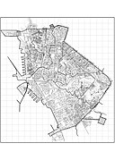
 Map of the City of Manila showing points of interests


See also
- Luzon
- Geography of the Philippines
- Kingdom of Tondo
- Greater Manila Area
- Mega Manila
References
- ^ "Environment — Manila". City-Data. Retrieved February 26, 2017.
- ^ "Geography of Manila". HowStuffWorks. Retrieved 2010-04-13.
| Topics |  | |
|---|---|---|
| Government | ||
| Districts | ||
| Mixed-use developments | ||
| Beaches | ||
| Legislative districts | ||
| Administrative divisions | |
|---|---|
| Geography | |
| Government |
|
| History | |
| Economy | |
| Public services and utilities | |
| Education | |
| Culture | |
| Transportation | |
| Other topics | |